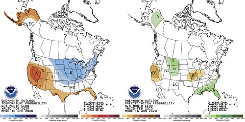
The Climate Prediction Center is out with the February outlook and a look at Spring, too. While fEbruary is looking like cooler-than-average conditions may prevail, the long-term look suggests that temperatures may rebound in March and April – offering a better chance for above-average conditions.
Quick local discussion
For South Mississippi, our forecast was originally for “cooler and drier” conditions when we issued the Winter Outlook on October 6th. But seeing that we air-balled January’s forecast after the area got stuck in a week-and-a-half of heat and rain, I’m not too confident in February’s forecast anymore.
The CPC suggests an equal chance that the area is cooler-than-average or warmer-than-average. with a better chance for above average precipitation (I know what you’re thinking, “Great, just what the area needs…”).
The recent storm track, and the forecast for the overall pattern as we enter February, would suggest that systems will pass through just to our north, pulling in more Gulf of Mexico heat as they pass. And the southern track also means fewer shots of cold Canadian air. That would lead me to lean toward warmer-than-average conditions prevailing. And above-average precipitation. That said, watching the MJO, could lead me to lean the other direction, too. The area is one-“blocking ridge”-to-our-northeast away from getting a heap of cold dumped on our front lawn.
So. Miss February Outlook
With all of that being said, I’m going to shift my original outlook from five months ago. February outlook from me: Average temperatures and average precipitation.
From the Climate Prediction Center
Here is a look at the February discussion from the CPC:
The temperature and precipitation outlooks for February largely reflect dynamical model guidance, statistical relationships with modes of variability in the tropics, and some consideration for local sea surface temperatures. The Madden-Julian Oscillation is strong and likely to play a significant role in the upcoming month, which potentially means increased variability and a pattern flip in the middle of the month. The potential for escalated variability
decreases the overall confidence in the outlooks.
The temperature outlook for Alaska reflects model guidance in that above normal temperatures are favored for western Alaska in all but 2 of the NMME models, though the probabilities are just slightly higher than the NMME models. The slight increase in probabilities is supported by more recent runs of the CFS and lagged composites of a currently strong MJO event pointing toward a warming in the middle of the month. A cooler signal is evident for eastern Alaska, which contradicts some trends , so equal chances are specified there. A strong phase 5/6 of the MJO can also indicate a colder period for the eastern CONUS, approximately 15-30 days later. The colder period would not be expected to extend beyond about 15-20 days in length, as an active MJO would reverse the signal as it traversed the tropics.
Given that potential MJO signal and consistent model support, below normal temperatures are favored from eastern Montana to the Northeast and southward to the Tennessee Valley. Probabilities are highest where statistical measures and model forecasts agree. Trends are positive and signals for below normal temperatures moderate for the Southeast, so equal chances are indicated, except over Florida, where above normal temperatures are favored. The area where above normal temperatures are favored extends westward from Florida across the immediate Gulf Coast, into Texas and the Central and Southern Rockies, terminating at the West Coast. Across the Great Basin, above normal temperatures are favored by trends and some models, though signals are weaker in the older model runs and much stronger in more recent runs.
The MJO would support the development of a trough near Baja California, which could limit the southern extent of a broad dry area in many of the NMME models. The pattern that would support the cold air would also support multiple frontal passages over the eastern CONUS with northerly flow in the wake of each passage, resulting in overall dry conditions in the from the Midwest to the Central Plains and potentially leaving dissipating fronts across the Gulf Coast, enhancing odds for precipitation over the Southeast.
The precipitation outlook for Alaska is highly uncertain, though predicted above normal sea-surface temperatures in the Gulf of Alaska are likely associated with ridging there and a storm track pushed into mainland Alaska, so above normal precipitation is slightly favored for central Alaska. Storms that are pushed northward into Alaska, would have less of an impact on California and Oregon, so below normal precipitation probabilities are elevated for central California, western Nevada, and southern Oregon. That same storm track could support more activity for the Northern Rockies, and MJO composites indicate conditions supportive of more upslope potential, so above normal precipitation is indicated from eastern Montana to Northern Colorado.
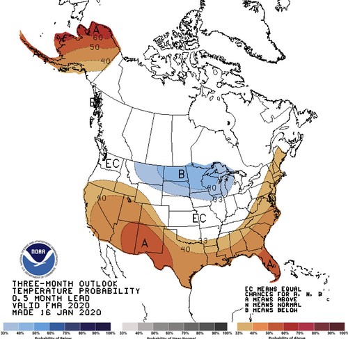
Beyond February, March and April may go down as warmer-than-average for places from Maine, down the East Coast, into the South and Southeast and all the way back into the Desert Southwest. If February ends up cooler-than-average for some of those places, as predicted, it would mean a pretty stout swing back into warmth come March.
Here is the long-term discussion from the CPC:
ENSO-neutral conditions continue across the equatorial Pacific Ocean, as represented in current oceanic and atmospheric observations. The official CPC ENSO forecast indicates that ENSO-neutral is most likely through the Northern Hemisphere spring 2020 (~60 percent chance) and summer 2020 (~50 percent chance).
The February-March-April (FMA) 2020 temperature outlook favors above normal temperatures from central and southern portions of the West, across the southern tier of the CONUS, and the East Coast states. Increased chances for below normal temperatures during FMA are forecast across the northern Great Plains, the Upper Mississippi Valley, and the western half of the Great Lakes. Equal chances (EC) of above, near, or below normal temperatures are indicated across the remainder of the CONUS. Above normal temperatures are favored throughout much of Alaska, with the exception of EC over the extreme southeastern mainland and the Southeast Panhandle region.
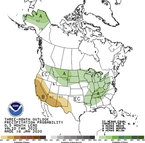
The FMA 2020 precipitation outlook indicates enhanced probabilities of above normal seasonal total precipitation amounts east-southeastward from the northern Intermountain region and northern Rockies across the northern Plains, most of the Mississippi Valley, the Great Lakes region, and Ohio and Tennessee Valleys. Below normal seasonal precipitation amounts are favored across southwestern Oregon, California, much of Nevada, Arizona, New Mexico, and parts of West Texas.
Equal chances (EC) are forecast among areas where seasonal precipitation amounts are expected to be similar to climatological probabilities. In Alaska, there are elevated probabilities of above normal seasonal total precipitation amounts from about the Alaska Range northward to the Arctic Coast, and EC for approximately the southern third of the state.
Note: For Graphical Displays of the Forecast Tools Discussed Below See: http://www.cpc.ncep.noaa.gov/products/predictions/90day/tools/briefing
TEMPERATURE
During FMA 2020 there are increased chances of above normal temperatures from central and southern portions of the West across the southern tier of the CONUS, and the East Coast states. This is based on the temperature consolidation tool (which includes the NMME), the CFS, the ENSO-OCN tool, and to some degree the CBaM. The latest outlook differs from the one issued last month (also valid for target season FMA) in that the Pacific Northwest/northern Rockies is now indicated as EC rather than favoring above normal, and trends support the highest probabilities for above normal temperatures over the Southwest to be shifted over/near New Mexico (in excess of 50%). The latest outlook also differs from the previous one for FMA over the Northeast/Upper Mid-Atlantic where indications generally show a slight westward shift of above-normal temperatures.
Increased chances for below normal seasonal mean temperatures during FMA are forecast across the northern Great Plains, the Upper Mississippi Valley, and the western half of the Great Lakes, which differs slightly from the previous outlook in that the eastern portion of the favored below normal temperatures (Lower Lakes region) now looks less convincing. This is borne out by the temperature consolidation tool (which includes the NMME suite of forecasts), CCA, and OCN trends . The probabilistic NMME and the PAC predict enhanced odds of near normal temperatures for this region. Above normal temperatures are favored throughout much of Alaska, with the exception of EC over the extreme southeastern mainland and the Southeast Panhandle region, with this greater uncertainty indicated by the CFS and CBaM (which predict near to below normal temperatures), and the NMME-based solutions.
Maximum probabilities for above normal temperatures are depicted over northwestern Alaska, in part related to the climatologically earlier breakup of sea ice near the coast, and historical temperature trends . For remaining areas of the CONUS and Alaska, where models and tools are either contradictory or predict weak signals , EC is favored.
For MAM and AMJ 2020 (leads 2 and 3) above normal temperatures are favored over all of Alaska, with the highest probabilities (in excess of 70% and 60%, respectively) focused over the northwest part of the state. This is supported by the climatological breakup of sea ice approximately a month earlier in recent decades, related historical temperature trends , the temperature consolidation tool, CCA, SST Constructed Analog (SST-CA) tool, and to some degree the CFS.
Above normal temperatures are also favored for much of the CONUS, with the exception of the northern High Plains generally eastward across the northern half of the Mississippi Valley into the Great Lakes region. Most tools suggested a larger extent of above normal temperatures across the CONUS, but part of the reason for the extensive area of EC across the northern CONUS is the likelihood of an increasing contribution from soil moisture, with above normal precipitation forecast for FMA, MAM, and AMJ 2020.
For the remaining seasons, MJJ 2020 through FMA 2021, the seasonal outlooks were heavily tilted toward historical climate trends , as incorporated into the statistical consolidation tool (which does not include the NMME guidance).
PRECIPITATION
The precipitation outlook for FMA 2020 favors above normal seasonal total precipitation amounts east-southeastward from the northern Intermountain region and northern Rockies across the northern Plains, parts of the Mississippi Valley, the Great Lakes region, and Ohio and Tennessee Valleys. Within this broad area, there are two separate areas of slightly higher probability (>40%); one in the northern High Plains, and the other in Kentucky/Tennessee.
In-between these two probability maxima (in the unseasonably wet Dakotas & Upper Midwest), there are slightly lower probabilities for above normal precipitation, between 33% and 40%. The monthly precipitation outlook for February depicts below normal precipitation over portions of the Middle Mississippi Valley, which at first glance appears to conflict with the seasonal precipitation outlook. However, February is typically a drier month for this region, so this is consistent with short-term dryness and variability. The updated FMA outlook is supported by the precipitation consolidation tool (which includes the NMME), the CFS, and trends .
The ENSO-OCN, which is often used as a first guess, depicts above normal precipitation over the northern High Plains and northern Rockies, and from the south-central Mississippi Valley northeast to the Great Lakes. Above normal precipitation is also favored over Alaska from about the Alaska Range poleward to the Arctic Coast, as supported by various models/tools. There are increased odds of below normal precipitation over southwestern Oregon, California, much of Nevada, Arizona, New Mexico, and parts of West Texas. This area of favored below normal precipitation has been shifted somewhat west and north from last month’s outlook (valid for FMA). Equal chances (EC) is indicated for those areas where seasonal precipitation amounts are expected to be similar to climatological probabilities.
For MAM and AMJ 2020 (leads 2 and 3), above normal precipitation continues to be favored for northern and central Alaska (north of the Alaska Range) based on the precipitation consolidation tool, the CBaM, NMME guidance, and the SST-CA. Over the CONUS, the large area of favored wetness in FMA gradually shifts eastward in MAM and AMJ, with the highest probabilities (>40%) depicted over the Ohio Valley, most of the Appalachians, and the Mid-Atlantic. This expected evolution generally parallels the precipitation consolidation and ENSO/OCN tool outputs during these seasons.
By AMJ, the CFS and the SST-CA differ from the ENSO/OCN and consolidation by focusing the heaviest precipitation farther south and west over the Gulf Coast states. The area of favored below normal precipitation across the western CONUS gradually shifts northward by AMJ to include the Pacific Northwest, northern Intermountain region, and northern Rockies, signaling the transition from the climatological rainy season to the dry season.
Coverage of favored areas for anomalous precipitation decrease during the summer as forecast confidence diminishes with a weakening signal among tools and convective precipitation becomes more dominant. The favored areas of below or above normal precipitation at later lead times are based largely on historical trends.