Good morning, folks, and happy Friday! The main story this week has been, and will continue to be, the above-average temperatures with highs soaring into the triple digits in some cases. Across most of the Southeast, however, there will be a chance for an afternoon storm to help cool things down.
Current Weather Story

As you can see from the image above, the Southeast is painted with the orange and purple, representing Heat Watches and Excessive Heat Warnings, respectively. Many of these watches and warnings remain in effect through Friday evening, with some in the Dallas-Fort Worth Metroplex remaining in effect until Sunday evening.
So what’s the reason for these dangerously hot temperatures? Why an upper-level ridge, of course!

This is a typical pattern that we’ve been seeing over the past few years, where a strong upper-level ridge has been setting up over the Southeast. If we compare these 500mb heights to the average 500mb heights, we can see that this upper-level ridge is a bit stronger than average.

What’s more telling, though, is when we see the temperature anomalies a little bit closer to the surface. At the 850mb level, about 5,000ft above sea level, the temperatures are well above average, as shown by the image below.

Generally speaking, the 850mb temperatures are around 2-5C above average for most of the Southeast, with a few pockets of +5C, particularly across parts of Texas, Oklahoma, Arkansas, Missouri, and parts of North Carolina.


So, all of this put together corresponds to some very hot temperatures at the surface. Because of the time of writing this forecast (3:00 PM yesterday, June 7), let’s take a look at the highs for yesterday… For much of eastern Texas, eastern Oklahoma and portions of Arkansas, temperatures exceeded 100F, and elsewhere across the Southeast, the temperatures rose to the mid-to-upper 90s. These temperatures are 5-15F above average for this time of year! But, to be fair, what the actual temperature isn’t important in extreme heat situations, we care about how it feels.

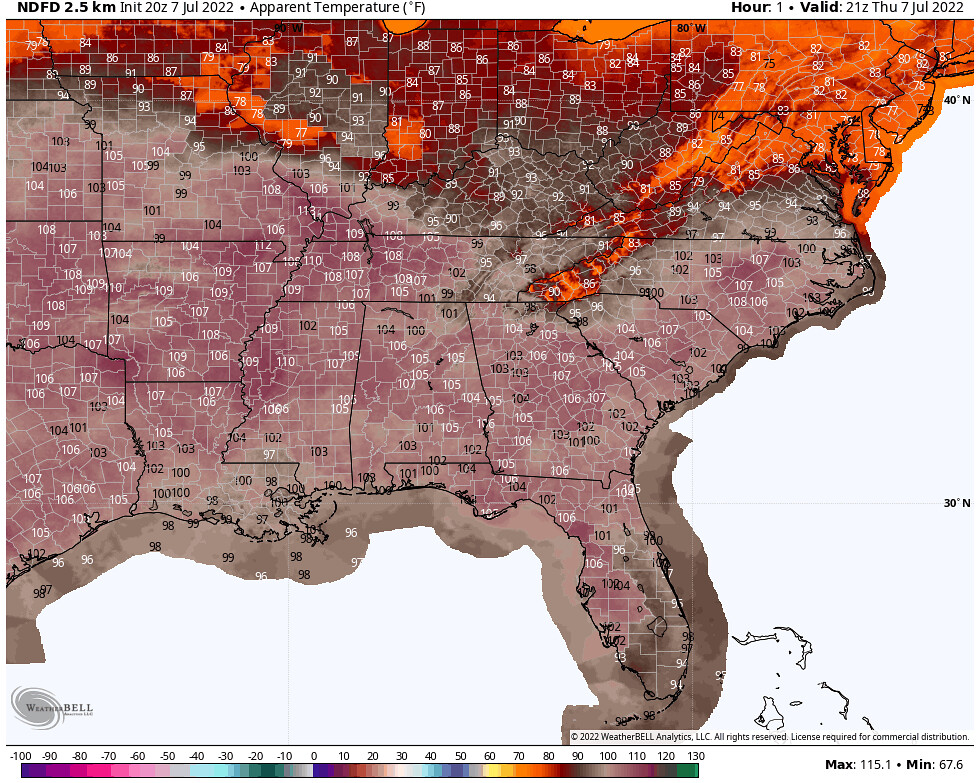
Considering dew points were in the low-to-mid-70s for much of the Southeast, with exception to parts of Texas and Oklahoma, the feels-like temperatures were well into the 100s, exceeding 105F and even 110F in most places! This is heat you don’t want to mess with… Per the National Weather Service, “extreme heat and humidity will significantly increase the potential for heat related illnesses, particularly for those working or participating in outdoor activities… Drink plenty of fluids, stay in an air-conditioned room, stay out of the sun, and check up on relatives and neighbors.”
Today’s Forecast
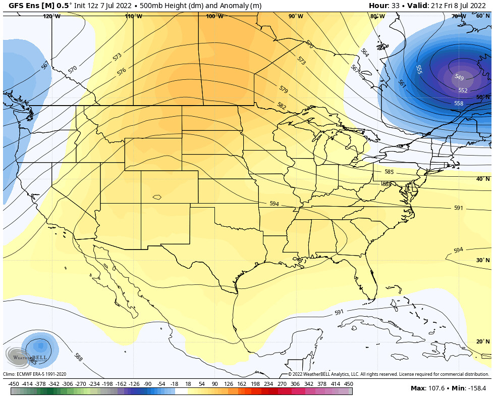
Models are in good agreement that the ridge will continue to build through Friday, shifting westward slightly with a center over Texas. This will once again produce above-average 850mb temperatures for Friday afternoon.

At the surface, temperatures will one again be dangerously hot, with locations in eastern Texas and parts of Oklahoma and Arkansas seeing temperatures once again above 100F, and other locations across the Southeast seeing high temperatures in the mid-to-upper 90s.


Thanks to dew points in the area in the mid-70s, with exception once again in parts of Texas, the feels-like temperatures will be over 100F for much of the Southeast, with values exceeding 110F in some cases. The locations with the greatest heat index will be where the warmest temperatures and the highest dew points overlap, which will be around the Mississippi River Valley region in northern Mississippi, eastern Arkansas, western Tennessee, western Kentucky, southeastern Missouri, and southern Illinois. Regardless of the actual numbers, temperatures will be dangerously hot across the Southeast today, so take extra care into making sure that yourself and those around you are well-hydrated and are able to use an air-conditioned space.

As far as the chance for afternoon showers and thunderstorms, a mid-level disturbance swinging through the region will help disrupt the atmosphere just enough for some thunderstorms across much of the region, with the greatest chance for widespread showers and thunderstorms for Georgia, Tennessee, Kentucky and the Carolinas. However, showers and thunderstorms can be expected as far west as Mississippi and Alabama.

Tomorrow’s Forecast
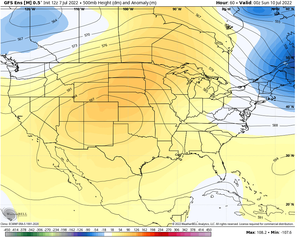
Models are in agreement that the high pressure continues to strengthen and move westward, with a center now moving more toward the Rockies. With the ridge now displaced off to the west, this will give us the opportunity for more showers and thunderstorms to sneak into the region by Saturday night. Still though, the temperatures will remain well-above average for this time of year.


Feels-like temperatures will continue to exceed 110F in parts of eastern Texas, eastern Oklahoma, southern Arkansas, northern Louisiana and portions of Mississippi, with values exceeding 100F elsewhere across the Southeast.
However, as I just mentioned, with the upper-level ridge moving to the west, some locations will have a greater chance for widespread showers and thunderstorms as a disturbance is allowed to move through portions of the Southeast.


Per the GFS ensemble model, a disturbance pushing through parts of Kentucky, Tennessee, Virginia and North Carolina will meet up with a weak trough located off the shore of the Carolinas and lead to enhanced atmospheric lift and precipitation. Most of this activity will arrive Saturday afternoon into Saturday evening, which will unfortunately allow for temperatures to soar again in most places.
Sunday’s Forecast
By Sunday, much needed relief arrives near the Atlantic Coast, courtesy of the interaction between the two disturbances mentioned above. However this will only keep temperatures down for the Carolinas and portions of Georgia and northern Alabama, with much of Mississippi, Louisiana and eastern Texas still experiencing above-average temperatures and dangerous heat indices.


While the rain will keep temperatures cooler in some parts of the Southeast, scattered afternoon showers and thunderstorms are possible elsewhere across portions of Georgia, southern Alabama, southern Mississippi and southeastern Louisiana.

3-Day Southeast City Forecast
| Dallas, TX | ||
| Friday | Saturday | Sunday |
| High: 104F | High: 104F | High: 102F |
| Low: 82 | Low: 82 | Low: 82 |
| Precip: None | Precip: None | Precip: None |
| Houston, TX | ||
| Friday | Saturday | Sunday |
| High: 98F | High: 99F | High: 100F |
| Low: 81F | Low: 81F | Low: 82F |
| Precip: None | Precip: 10% | Precip: 20% |
| New Orleans, LA | ||
| Friday | Saturday | Sunday |
| High: 89F | High: 90F | High: 87F |
| Low: 82F | Low: 82F | Low: 83F |
| Precip: 60% | Precip: 50% | Precip: 80% |
| Little Rock, AR | ||
| Friday | Saturday | Sunday |
| High: 102F | High: 98F | High: 93F |
| Low: 81F | Low: 82F | Low: 74F |
| Precip: None | Precip: 40% | Precip: 10% |
| Memphis, TN | ||
| Friday | Saturday | Sunday |
| High: 102F | High: 96F | High: 94F |
| Low: 82F | Low: 81F | Low: 73F |
| Precip: 10% | Precip: 30% | Precip: None |
| Birmingham, AL | ||
| Friday | Saturday | Sunday |
| High: 96F | High: 95F | High: 91F |
| Low: 79F | Low: 80F | Low: 75F |
| Precip: 30% | Precip: 80% | Precip: 30% |
| Atlanta, GA | ||
| Friday | Saturday | Sunday |
| High: 93F | High: 90F | High: 85F |
| Low: 75F | Low: 76F | Low: 72F |
| Precip: 40% | Precip: 80% | Precip: 80% |


