Early Wed AM South Mississippi severe weather update for 4/18/19 SVR threat
Author: Nick Lilja
|| Published: 4/17/2019 at 12:35am
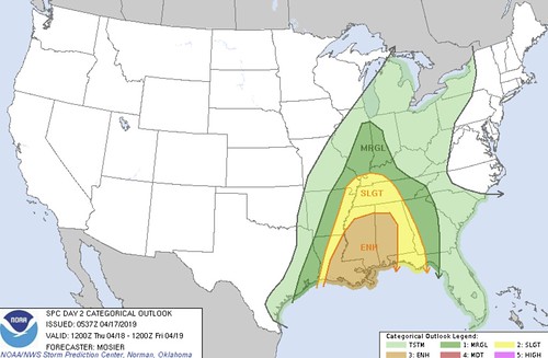
SPC Day 2 outlook // Courtesy: NOAA
The Storm Prediction Center has continue the Enhanced Risk for the Gulf Coast region. And we are now getting into the timeframe where we can start to talk about specifics. A couple of things to keep in mind, though…
1. The specific spot-forecast model data will likely change at least a little
2. The timing may shift slightly
3. The overall threat for thunderstorms is unlikely to change
And please know that this forecast is based off of the overnight data Tuesday night and into Wednesday morning. So if you read this after 10pm on Wednesday, there may be a more accurate forecast available.
Early thoughts on what to expect
The trough in the middle of the country is going to be pretty stout, and will be capable of producing and sustaining severe weather.
As a cold front moves through the area and catches up to a lingering boundary, it will ignite showers and storms – some severe – across parts of Louisiana and Mississippi on Thursday afternoon and evening. Every thunderstorm will include heavy rain, frequent lightning, wind gusts of at least 30mph. Beyond that, storms may include up to 70mph, up to 1.5″ hail, and the potential to produce a tornado. And, unfortunately, the potential to produce a strong tornado.
The forecast soundings from the NAM-3km are always a bit over the top, but take a look:
4-17-00z NAM-3km Forecast data sounding // Courtesy: Pivotal Weather
This data is probably near an updraft within a storm, but that is a pretty potent sounding. This would give a Karrie Meter rating of 6.68. Divided in half to put it on the SPC scale and it shows a 3.34 – an Enhanced Risk.
The timeline looks like this..
Loose estimated timeline based on convection-allowing model guidance
On the above map, the orange/yellow lines indicate where storms will be near at the designated times of the day. For example, by early afternoon storms will be near Oxford, MS, Vicksburg, MS, and Alexandria, LA. By late night, storms will be around the Pensacola, FL area.
From the Storm Prediction Center
..SUMMARY…
Severe thunderstorms are expected Thursday across the Lower and Middle Mississippi Valleys as well as across the Southeast and Tennessee Valley. Damaging winds and a few tornadoes are possible, especially from Louisiana into Mississippi.
…Lower MS Valley/Southeast…
A convective line will likely be ongoing from the mid MS Valley southwestward into east TX Thursday morning. Current expectation is for the line at this time to be fairly weak, given it will have likely outrun the surface front and instability will be at its diurnal minimum. Throughout the remainder of the morning and into the early afternoon, a shortwave trough moving across the southern Plains will accelerate eastward towards the lower MS Valley. As it does, an attendant surface low will also accelerate northeastward while strengthening and southerly low-level flow will increase. At the same time, resultant mass response will help advect upper 60s/low 70s dewpoints into southern LA/MS and mid 60s into the much of the remainder of LA and MS ahead of the line.
Day 2 severe risk from the SPC
All of these factors will likely result in a re-strengthening of the convective line (or perhaps just new development along the front overtaking the antecedent and weakening line) as it moves into LA and continues into MS. Vertical shear will be very strong, and this strength as well as its orientation to the front are favorable for the development of well-organized QLCS. The strong large-scale forcing for ascent and the robust low-level jet also suggest organization is likely. Primary severe threat will be damaging wind gusts, some of which could exceed 60 kt. Several line-embedded tornadoes are also possible.
Additionally, cellular development is possible within the open warm sector ahead of the line amidst wind profiles supportive of supercells. As such, most persistent updrafts may become surface-based and capable of damaging wind gusts and tornadoes. Overall, in both the convective line and cellular development ahead of the line, the potential exists for a strong tornado or two.
…Mid-South into the Mid MS Valley…
Much of this region will be displaced north of the better instability which will mitigate the overall severe potential, despite forcing for ascent and vertical shear supporting severe. Two rounds of storms are possible, one early in the period and another following on the front. Isolated damaging wind gusts could occur within the strongest storms.
…MAXIMUM RISK BY HAZARD…
Tornado: 10% SIG – Enhanced
Wind: 30% SIG – Enhanced
Hail: 15% – Slight
From the Weather Prediction Center
…THERE IS A SLIGHT RISK OF EXCESSIVE RAINFALL FROM THE GULF STATES INTO THE SOUTHERN OHIO VALLEY…
There exists an increasing signal for rainfall capable of producing flash flooding across the area. A neutral but amplified longwave trough will slowly push eastward while subtly taking on a negative tilt late in the forecast period. Deep layer southerly flow supporting intense moist advection off the Gulf of Mexico will cause PWAT anomalies climbing to +2 standard deviations being drawn as far north as Lake Erie. This combination of low-level convergence along the eastward propagating cold front, and intense synoptic lift within the jet diffluent region and in response to mid-level height falls supports the potential for heavy rain.
Moderate to high probabilities front he ECMWF/SREF exist for 1″/6hr from the Arklamiss region through AL, central TN, and western KY where a finger of higher instability overlaps with modest frontogenesis to enhance mid-level omega. There is a multi-model signal for 2-3″ or more of rainfall during this period, much of which may fall onto soils already saturated by
antecedent rainfall of 200-400% above normal during the past 7 days.
Despite the increasing likelihood for significant rainfall on top of saturated soils, there remains enough uncertainty in the guidance solutions to prevent an upgrade in the risk outlook category at this time. The models are handling the evolution of a surface wave progged to develop along the front quite differently, which could significantly impact the location of the heaviest rainfall. At this time an ECMWF/UKMET/GEFS blend is referred, but the uncertainty combined with the likely relative fast longitudinal translation of the cold front precludes a Moderate Risk at this time.
Further east, there exists a modest signal for some terrain enhanced rainfall along the southern terminus of the Appalachian Mountains. At this time have opted to expand the MRGL risk eastward to cover this area as intense rainfall may shift into the terrain late on Day 3. ECMWF probabilities for 1″/6hr have increased across parts of NE GA into SW NC where rainfall the past 7 days have been slightly above normal, but timing differences and waning instability prevent a Slight Risk at this time.
Updraft Helicity streaks for South Mississippi
I really need to do a whole write-up on how what Updraft Helicity is, why it is important and how using it from convection-allowing models can be useful. Research has suggested that, when values eclipse the 75-100 m2/s2 range, the models can pick out the potential for well-organized supercells capable of producing tornadoes.
Areas where strongest storms may develop
Models aren’t great at picking where these storms will develop, specifically, but can do a good job at picking out the binary “yes or no” question.
Looking at the available data, there are a handful of streaks moving through the area between the four convection-allowing models I used. Based on that and other parameters, I believe the areas highlighted on the map to the right show the highest probability to see the stronger storms.
Does this mean guaranteed severe weather? Guaranteed tornado?
Not a chance.
All it means is that those are the two areas where the atmosphere is capable of sustaining severe weather. It’ll still be another 24 hours from being able to identify specific streaks and corridors for the highest risk.
But if you are inside or near one of those two circles, it would behoove you to pay very close attention to the forecast on Wednesday and Thursday as the data continue to roll in regarding what will happen Thursday evening.
Have a plan
Make sure you take time to think about what you would do if a tornado warning was issued for your area. Where would you go? How safe is that spot you picked? What supplies would you need/want?
Author of the article:
Nick Lilja
Nick is former television meteorologist with stints in Amarillo and Hattiesburg. During his time in Hattiesburg, he was also an adjunct professor at the University of Southern Mississippi. He is a graduate of both Oregon State and Syracuse University that now calls Houston home. Now that he is retired from TV, he runs this site and its app in his spare time.