South Mississippi severe weather update for April 18th
Author: Nick Lilja
|| Published: 4/16/2019 at 2:27pm
A rare Day 3 mid-day update from the Storm Prediction Center.
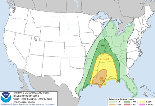
…THERE IS AN ENHANCED RISK OF SEVERE THUNDERSTORMS ACROSS MUCH OF LOUISIANA INTO CENTRAL MISSISSIPPI…
AMENDED TO ADD ENHANCED RISK FOR LOUISIANA AND MISSISSIPPI
…SUMMARY…
Severe thunderstorms are expected Thursday across the Lower and Middle Mississippi Valleys as well as across the Southeast and Tennessee Valley. Damaging winds and a few tornadoes are possible, especially from Louisiana into Mississippi.
….Louisiana and Mississippi upgraded to Enhanced Risk for Thursday…
Models are in good agreement with the general setup for Thursday, indicating a deepening upper trough across the lower MS Valley. Wind profiles will increase throughout the period, ahead of a developing squall line. Models indicate substantial low-level moisture will surge northward early through midday across LA, with cells possibly developing ahead of the ongoing frontal convection to the west. Any cells ahead of the line could be supercells capable of tornadoes. With time, a consolidation into a severe QLCS is expected. Hodographs will be supportive of supercells and/or embedded corridors of significant wind and a few tornadoes. A strong tornado is possible.
SPC Risk map for Day 3
— Previous Discussion —
…Mid/Lower MS Valley…Southeast…
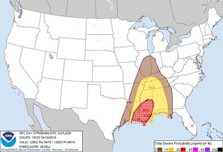
SPC probabilistic map showing hatched area highlighting increased severe risk
Thunderstorms will likely be ongoing at the beginning of the period from the mid MS Valley to the TX Gulf Coast along a cold front gradually pushing eastward/southeastward. Moist and moderately unstable air mass ahead of the cold front coupled with strong flow aloft supports the potential for occasionally strong updrafts capable of damaging wind gusts and isolated hail. Severe threat will exist throughout the entire period, from southeast TX early Thursday morning to western GA early Friday morning.
The cold front will exist just ahead of a deep upper trough extending the length of the central CONUS. Some deepening of this upper trough is anticipated as an embedded shortwave trough drops through the central Plains towards the lower MS Valley. Progression of this shortwave will cause the lead southern-stream shortwave trough to quickly eject through the lower MS Valley and Southeast ahead of it. Resulting mass response and increase in large-scale ascent may result in a corridor of higher severe potential from southeast LA across southern/central MS into west-central AL. However, uncertainty regarding speed of the front as well as questions regarding the extent of diurnal heating currently preclude delineating any probabilities higher than 15%.
Quick summary… in non-meteorologist-speak
A cold front is going to move through with a line of storms. Before the cold front swings through the area, there may be a few storms that fire up ahead of the line, given the atmospheric setup, these storms would have the chance to become well-organized and supercellular.
Those supercell storms could produce larger hail and a few tornadoes. And given the setup, perhaps stronger tornadoes or longer-track tornadoes. The fact that the SPC took the time to include a hatched area is a sign that they are concerned about significant severe weather.
The timeline for south Mississippi is between 3pm and 11pm.
Author of the article:
Nick Lilja
Nick is former television meteorologist with stints in Amarillo and Hattiesburg. During his time in Hattiesburg, he was also an adjunct professor at the University of Southern Mississippi. He is a graduate of both Oregon State and Syracuse University that now calls Houston home. Now that he is retired from TV, he runs this site and its app in his spare time.