Introduction: Winter brings not only picturesque snowscapes but also the potential for extreme and hazardous weather events. In this educational post, we’ll explore two of winter’s most significant meteorological challenges: blizzards and other winter storms. We’ll uncover their unique characteristics, formation, impacts, and essential safety measures.
Characteristics of Winter Storms: Winter storms encompass a range of cold-weather phenomena, including blizzards. Here are some shared characteristics:
- Cold Temperatures: Winter storms are characterized by frigid temperatures that can lead to icy conditions and freezing.
- Precipitation: They bring various types of precipitation, including snow, sleet, freezing rain, and even hail.
- Icy Roads: Winter storms can make roads and sidewalks dangerously slippery, leading to travel disruptions and accidents.
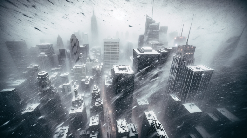
Characteristics of Blizzards: Blizzards are a specific type of winter storm known for their extreme conditions. In order for something to be considered a technical blizzard, it must have the following: large amounts of snow OR blowing snow, with winds in excess of 35 mph and visibility of less than 1/4 mile for an extended period of time (at least 3 hours).
Formation of Winter Storms and Blizzards: Both winter storms and blizzards require specific meteorological conditions to form:
- Cold Air Mass: Cold air from polar regions or the Arctic is necessary for the development of winter storms.
- Moisture Source: Moisture, often from nearby bodies of water, combines with the cold air to create wintry precipitation.
- Low-Pressure System: A low-pressure system is crucial for intensifying the storm, increasing precipitation and wind.
- Temperature Gradient: The clash between the cold air mass and warmer, moister air leads to varying types of winter precipitation.
Other helpful things:
- Strong Upper-Level Winds: High-altitude winds, such as the jet stream, can play a significant role in the development and intensification of winter storms.
- Orographic Lifting: Mountains can enhance snowfall during winter storms as moist air is forced to ascend over mountain ranges, it cools and condenses, leading to heavier snowfall on the windward side of the mountains.
- Atmospheric Instability: Instability in the atmosphere can lead to more intense and convective snowfall within a winter storm.
- Convergence Zones: Areas where different air masses converge or collide, such as frontal boundaries, can act as focal points for the development of intense winter storms.

Impacts and Safety Measures: Winter storms and blizzards can have significant impacts and require careful preparation:
- Travel Disruptions: Snow and ice can lead to road closures, flight cancellations, and stranded vehicles. Avoid unnecessary travel during winter storms.
- Power Outages: Heavy snow and ice can cause power outages. Have an emergency kit ready, including food, water, blankets, and flashlights.
- Hypothermia and Frostbite: Extreme cold can quickly lead to frostbite and hypothermia. Dress warmly, cover exposed skin, and limit exposure to the cold.
- Visibility Challenges: Low visibility during blizzards makes navigation dangerous. Stay indoors and avoid travel until conditions improve.
- Deicing and Sanding: Use deicing materials on sidewalks and driveways to prevent ice buildup, and sand for traction on slippery surfaces.
Take Home: Winter storms and blizzards are formidable adversaries during the cold season, demanding respect, preparation, and vigilance. Understanding their characteristics, formation, and safety measures is essential for protecting yourself, your family, and your community during these challenging weather events.
We hope this exploration of winter storms and blizzards has provided valuable insights and emphasized the importance of staying informed and prepared. If you have further questions or topics you’d like us to explore, please feel free to reach out. Stay safe and stay warm during winter’s fury!


