I knew people were going to die. Messaging was intense and started earlier than normal because I knew it was going to be a bad day. A very bad day.

But this isn’t just about the forecast. Or the messaging.
This is about the storm. The tornado.
This is about You.
The day is happened
It is a day no one wants to endure. An EF-3 tornado move through parts of Lamar and Forrest counties, laying waste to everything in its path.
The tornado had wind of 145mph, it was about a half mile wide and was on the ground for about 31 miles. It killed four people. It injured more than 50. And tore through more than 1,000 separate homes.
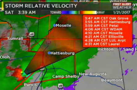

The hardest hit areas were on the south side of Hattiesburg and out in Petal. The damage was extensive. The timing couldn’t have been worse. It passed through Hattiesburg and Petal between 330 and 430 in the morning.
Most people were asleep. A lot of people got the warning. Some did not. And for some it was too late. A few got the warning, and did the right thing, but it didn’t matter. When an EF-3 tears through a home, sometimes there isn’t enough left to save a life.
The storm scared many people for life. And between the 2013 tornado that went through Hattiesburg and Petal, the 2014 tornado in Columbia, the 2015 tornadoes to start the year, the 2016 EF2 in Lamar county (also on January 21st), and this 2017 tornado that went through Hattiesburg and Petal, the folks of the Pine Belt became a bit more sensitive to severe weather.

Understandably, too. Mother Nature spent four consecutive years reshaping the landscape of South Mississippi. Tearing through forests, neighborhoods, and pastures all the same.
Even a year later, as people were remembering the storm and those who were lost, there was another threat for storms on the 22nd of January in 2018. An EF1 tornado moved through Covington and Jones county.
Then in December of 2019, another EF-3 swept through the area. This one moving through downtown Laurel.
It seemed like the area couldn’t catch a break.
Rebuilding after the storm
Pine Belt Strong became the rally cry after the storm swept through. If there is one thing that I learned in my seven years in Mississippi it is that folks help out when others are in need.
And they showed out for this recovery effort.
Donations came pouring in. More than 300,000 dollars were raised to help recovery efforts through a telethon at WDAM.

People showed up with hammers and ladders, pickups and even Bobcats to help clear debris and rebuild for those in need.
When people couldn’t afford to rebuild, R3SM stepped in to help those who didn’t have the means to completely rebuild a house or replace a roof.
Then and now
I wish I could say that everything is back to normal and recovery efforts were 100-percent successful. There are still people recovering. Other families will never be the same. Business and churches were displaced.
An entire neighborhood will never be the same in Hattiesburg.


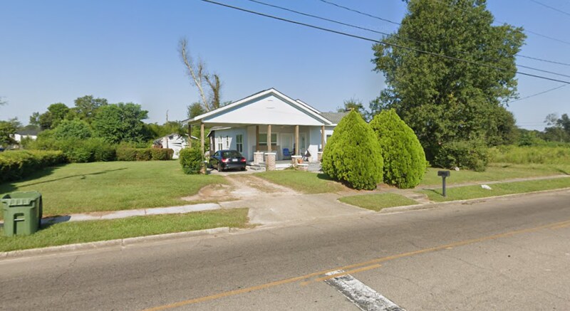
In fact, a good visualization of neighborhoods forever changed is with the house on Edwards Street from the video above. What was once a shady street with a nice place to relax in July. Is now baking in the Summer sun.

Moving forward
Tornadoes are the ultimate ‘blink of an eye’ catastrophe. And for south Mississippi, they can strike at any time of day, any time of year. So long as the ingredients are there, it is important to be prepared.
As a forecaster, it was a difficult day to forecast. Not because the forecast was tricky, but because I already knew the outcome. Death and destruction were likely. I learned that anytime I see something that looks like the image below, it is double important to pay attention.

Please Note: I’ve reached out to handful of folks for comments about this day, the recovery, and rebuilding efforts. I’m still waiting to hear back. But as soon as I do, I’ll be sure to update this story with quotes and extra information.


