Happy Saturday, everyone! As the only intern on this site from Kentucky, I wanted to start off by saying that I hope that everyone has heard about what happened in the Southeastern part of my state. I’m going to take a brief minute to discuss some things on my mind. After all, I do consider Kentucky in the Southeast.
A lot of times, especially for meteorologists, we can get caught up in maps and numbers, and get distanced from what really happens on the ground. Risk maps that we show are good at conveying a threat, but sometimes it’s easy to forget what that threat can look like. Unfortunately, we were harshly reminded of what can happen during a ‘perfect storm’ of bad conditions.
If you weren’t aware, around 9” of rain fell in a short time over the mountainous terrain of SE Kentucky, and led to a flooding disaster early Wednesday morning. As I type this, the death toll sits at 25, a shocking and heartbreaking number. It’s still hard to comprehend a few days after the fact.
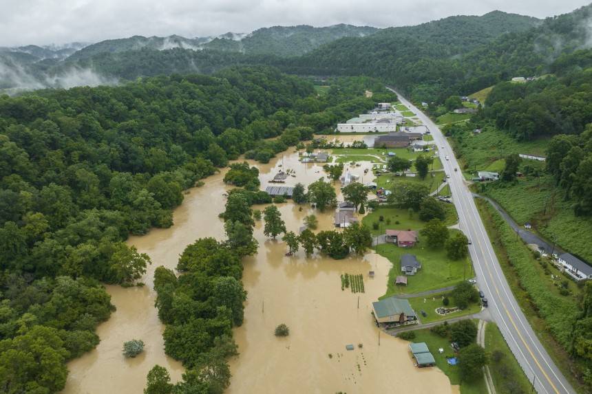
I’m not sure exactly where I had this talking point going, but just remember that extreme weather can happen and it can have a major cost. When we talk about flash flooding, there’s a reason. Flash Flood Warnings are important and should be taken seriously. I encourage you all to go read up on some of the survivor stories, look at some of the pictures, and help if at all possible. It can happen anywhere at any time.
With that aside, let’s take a look at what’s upcoming across the Southeast.
Unfortunately, one of the biggest stories may be flooding again, depending on where you live. The main 500 mb ridge axis is forecast to run from Savannah, GA, to around Dallas, TX. In that zone, rain is going to be hard to come by, but on the North side of that line, heavy rain and storms are favored to occur.

The WPC shows a flash flooding risk fairly similar to what you might expect given the orientation and position of the ridge, with just a Marginal Risk of flash flooding for Northern portions of the Southeast. Portions of the Northern Ozarks and lower Missouri Valley are under a Slight Risk, with heavier rainfall totals expected there.

There is no organized severe weather threat in the Southeast for today. Isolated severe weather is possible if strong storms happen to produce gusty winds, but those will be few and far between.
Tomorrow, the overall pattern is going to remain the same.

The ridge is going to keep warm air over the far Southeast, while it starts to erode further West. This will allow more unsettled weather in the Northern portion of the region, which is unfortunate for many of the areas already impacted by flash flooding. The Slight Risk for flash flooding encompasses much of the Upper South and Mid-Atlantic.

The pattern is largely expected to remain the same again on Monday, with another flash flooding risk for KY/TN/VA. By the end of the day Monday, a large portion of the Southeast may have already seen 2” or more.

Notable exceptions are Southern GA/Northern FL, as well as Southwestern TX. These areas are where the ridging is the strongest, and the rain chances are going to be a lot lower.

Temperature wise, it follows an expected pattern as well. Where the ridging is stronger over the next 5 days, it’s going to be hotter than usual. This includes places like Savannah, GA, Raleigh, NC, and then areas in Texas such as Dallas and Austin.
3-Day Southeast City Forecast
| Dallas, TX | ||
| Saturday | Sunday | Monday |
| High: 99F | High:100F | High: 100F |
| Low: 81F | Low: 80F | Low: 81F |
| Precip: 30% | Precip: None | Precip: None |
| Houston, TX | ||
| Saturday | Sunday | Monday |
| High: 95F | High: 95F | High: 94F |
| Low: 78F | Low: 79F | Low: 79F |
| Precip: 40% | Precip: 30% | Precip: 30% |
| New Orleans, LA | ||
| Saturday | Sunday | Monday |
| High: 91F | High: 91F | High: 90F |
| Low: 78F | Low: 80F | Low: 79F |
| Precip: 40% | Precip: 30% | Precip: 60% |
| Little Rock, AR | ||
| Saturday | Sunday | Monday |
| High: 87F | High: 88F | High: 88F |
| Low: 74F | Low: 76F | Low: 75F |
| Precip: 80% | Precip: 60% | Precip: 30% |
| Memphis, TN | ||
| Saturday | Sunday | Monday |
| High: 89F | High: 86F | High: 89F |
| Low: 75F | Low: 76F | Low: 75F |
| Precip: 80% | Precip: 80% | Precip: 40% |
| Birmingham, AL | ||
| Saturday | Sunday | Monday |
| High: 88F | High: 88F | High: 89F |
| Low: 73F | Low: 73F | Low: 74F |
| Precip: 80% | Precip: 60% | Precip: 50% |
| Atlanta, GA | ||
| Saturday | Sunday | Monday |
| High: 88F | High: 87F | High: 90F |
| Low: 72F | Low: 73F | Low: 72F |
| Precip: 70% | Precip: 30% | Precip: 50% |


