For Louisiana, Mississippi and Alabama this is the second time this week the states will be dealing with the prospects of severe weather. Not ideal. Even places like Arkansas, Texas and Oklahoma will be getting in on the chance for bad weather this go around, too.
From the Storm Prediction Center:
Widely scattered to scattered thunderstorms are evident from eastern OK and parts of northeast TX across AR, in a zone of elevated low-level warm advection, moisture transport and isentropic lift to varying LFCs, north of the marine/warm front. Such development should continue in a sporadic/episodic manner throughout the day, with the approach of the southern High Plains shortwave trough and broad, gradually eastward-shifting, 35-45-kt LLJ. Isolated severe hail will be possible north of the warm front.
The best-organized severe threat is expected to develop as convection near and north of the warm front, and near the strengthening cold front, shifts southeastward and encounters increasingly unstable, surface-based effective-inflow parcels representative of the marine sector. Activity should aggregate gradually into a primary QLCS, with elements both forward-propagating southeastward across the Arklatex/Delta regions and backbuilding over portions of north-central/northeast TX. Damaging wind will be the main concern. Large hail is possible mainly near the west end where deep-later lapse rates are steepest, with isolated significant/2+ inch hail possible from any supercells that can develop before being undercut my the deepening cold-frontal slab. A few tornadoes may occur either from:
1. Mesovortices associated with QLCS LEWP/BOW features and/or line-embedded supercells;
2. Any warm-sector supercells that can form and mature east of the strongest EML over LA or the lower Delta region before being overtaken by the QLCS. This modal potential is more conditional and uncertain.Forecast soundings ahead of the cold front and south of the developing QLCS show lapse rates and MLCINH each increasing westward. Surface dew points 60s F and pockets of favorable surface heating should contribute to peak afternoon MLCAPE around 3000 J/kg over north-central/northeast TX, decreasing to around 500-800 J/kg in central MS, with maximal effective-shear magnitudes generally in the 40-50-kt range.
Severe potential will be limited on the north and east fringes of the outlook area by increasing lack of boundary-layer lapse rates/buoyancy poleward of the fronts, on the west part by stronger EML and cold-frontal undercutting, and on the south by nocturnal/diabatic boundary-layer stabilization.
Setup
Storms will move across I-20 across the region and fall south – along a Canadian-born cold front – toward the Gulf. Some of these storms may be severe with heavy rain, frequent lightning, wind up to 70mph, hail up to the size of golf balls, and the possibility of a few tornadoes.
As stated above by the SPC, the tornado threat is conditional and not a sure-thing. And would be most likely from supercell storms that would develop ahead of the line (the model does show a few storms, but none of them terribly robust) or within the line of storms near the kinks in the line.
Timeline
By 4PM: Showers and storms will develop this afternoon and early evening north of I-20 in Oklahoma, Arkansas, Louisiana, and Mississippi.
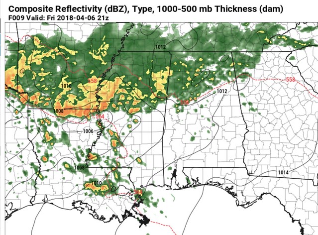
By 7PM: A line of storms will develop along a cold front in an east-to-west orientation be in the I-20 corridor, so if you live within a 15 minute drive of that interstate, be prepared for storms to be in your area by 7pm. Storms that develop ahead of this line would have the best chance to produce severe hail or a tornado.
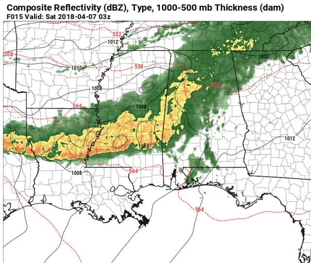
By 10PM: The east-west line of storms will be approaching places like Hattiesburg and McComb, Mississippi, and Alexandria, Louisiana. Storms will be mainly linear-only by this point and pose more of a rain and wind threat than a tornado and hail threat. Wind gusts may approach up to 60mph.
By 1AM: The line of storms will be closer to Mobile, Alabama, Wiggins, Mississippi, and New Orleans, Louisiana. Storms will still be mainly a rain and wind threat. Wind gusts may approach up to 60mph.
By 4AM: Storms move out of the area, lingering rain and rumbles of thunder are possible, but the severe weather threat will be over.
Nerd Alert
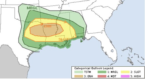
As an aside, I thought the Enhanced Risk that was nudged into our area yesterday was a bit pre-mature. Severe weather parameters for West Alabama, South Mississippi and East Louisiana aren’t exactly gang-busters.
Take a look…
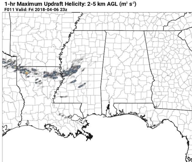
Updraft helicity is a good proxy (or, in this case, indicator) for estimating where the strongest rotation updrafts will be. And recall that rotating updrafts are needed for storm organization, to sustain supercell thunderstorms, produce hail, and ultimately create an environment that can produce a tornado.
The key/legend isn’t visible on that map, but the brighter the coloring on that map, the stronger the updrafts. And on that map, there are – generally – no bright colors.
Does that mean there is no threat? No. Sadly.
But it does mean that the threat for big hail and tornadoes should remain pretty limited in West Alabama, South Mississippi and East Louisiana.
We can dig in further, too. Because just one piece of evidence isn’t enough to satisfy me on a forecast. Now we can take a look at the Significant Tornado Parameter. And, well…
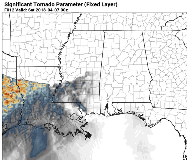
Not much there, either. Sure, there are some brighter colors in Texas, and eastern Louisiana. But for West Alabama, South Mississippi and East Louisiana, not as much.
The most interesting development during the last 18 hours of model guidance is the development of a little area of low pressure on the backside of the line of storms.
This could enhance the turning of the wind fields with height and, in turn, increase the threat for damaging wind gusts and the possibility for a brief tornado. But that threat would be pretty isolated.


