Keyword: Some.
Looking through a lot of the (more reliable) data this morning, and chatting with a few of my super-smart meteorological colleagues, has started to clarify a lot of what may – or may not – happen on Monday. While this is NOT the Final Set-It-In-Stone Forecast and things will still change… this is the start to getting some reasonable answers to some of the questions that have been unanswerable in recent days.
As always, if you are just here for the forecast, swipe down! But if you are here for the meat-and-taters, too, buckle up!
They call it ‘tater salad’
This Ron White reference will hopefully make sense in a second. And skipping this section will not inhibit your ability to understand the rest of this write-up. This is more of an aside, for people who are curious about weather forecasting in general.
Generally, when forecasting an event, once said event is within 48-72 hours, forecasters often switch from Global Models (GFS, ECMWF, GDPS, UKMET) to the Regional Models (NAM, RDPS, RAP) and they also look at the Convective-Allowing Models (NAM-3km, HRRR, HRW).
It is important to note that meteorologists, through the years, learn about certain biases that each model has and how those biases manifest themselves through time. For example, some models have a cold bias, others have a warm bias, and some have a moist bias. You may have heard residue of that bias when I give a forecast and I’ll say a model is “running a bit hot” when showing rainfall. You may think, “How is rain hot?” but it is more me highlighting the moist bias.
So, a lot like Ron White, these models can be given ‘aliases’ during an event because it either is or is not handling a certain aspect (or any aspect, sometimes) of the overall setup well. For example, The Euro nailed Sandy is a catchphrase within the meteorology community reminding everyone that sometimes the outlier is the correct choice. I’ve jokes that the NAM model is Not Always Mathematical.
Since weather is always happening, these biases, and subsequent aliases, can propagate event-after-event, year-after-year. Every next event meteorologists are yelling “The Euro nailed Sandy!” at each other.
And eventually, a lot like the Ron White joke, these models get a reputation for their biases and the alias given to them can show back up when you least expect it. And, when it does, what was once just a joke is now a something you may have to explain to someone.
So, what’s your point, Nick?
Now is that time.
I’m telling you all of that, to highlight that during the past few days you may have noticed that the data being kicked out by the models (and shared all over social media) has been going from warm to cold, then back to warm, then back to cold again. Snow is shown, then ice, then snow, then rain, then sleet.
You get the idea.
But no one has ever taken the time to tell you, the non-meteorologist, that one model is doing better than the other model, or this model is constantly too wet, or everyone calls this other model “Cold As ___ model” because it always producing snow.
And for newer meteorologists, general forecasters, weather enthusiasts, and the like, this is exactly explained anywhere, either. So, I wanted to write it down. Here is a look at the biases for each model for the Gulf Coast based on my experience and light research.
Looking at different models, here is a look at their biases when looking past 2/3rds of the way “out” in time for that particular model. for example, the NAM looks out 84 hours. So 2/3rds “out” is beyond 55 hours.
| Model | Total Hours into future | Hour when bias takes off | Winter season general bias @ >66% |
| GFS | 384 | 254 | Cold & Wet |
| ECMWF | 240 | 158 | Warm |
| GDPS | 240 | 158 | Cold |
| NAM | 84 | 55 | Warm & Dry |
| RAP | 31 | 20 | Cold & Dry |
| HRRR | 48 | 31 | Warm & Wet |
| HRW | 48 | 31 | Wet |
I’m sure meteorologists around the country may disagree with this table, but I’ve found it to be accurate for the Gulf Coast region of Louisiana, Mississippi and Alabama.
So now that we know that, we can then look at the data being presented to us and think, how accurate is this data given the backdrop of the biases.
Recall last week when the GFS was showing temperatures around zero in South Mississippi with multiple rounds of snow? Well, beyond 250 hours (10 days) out, it has a bias toward Cold and Wet. So it makes sense that it would kick out something like that.
The NAM model today keeps more of the coldest air stuck NW of Jackson, MS, on Monday. That means it shows no wintry precip making it south of a line from roughly Starkville, MS to Alexandria, LA. But that makes sense, it is biased to be warmer and wetter. Warmer means less frozen precip. And a wetter system is going to be tougher to cool down (Physics!).
Of note, if I was asked, I would call the NAM the Ron White of forecast models. Often it is drinking something, it can be a bit vulgar, and pretty funny.
To the Data
Like I said, things are starting to become a bit more clear as to how things are going to shake out. Though, this doesn’t – necessarily – mean that the Final Answer to the forecast is any easier to derive. It means we are making some steps in the right direction.
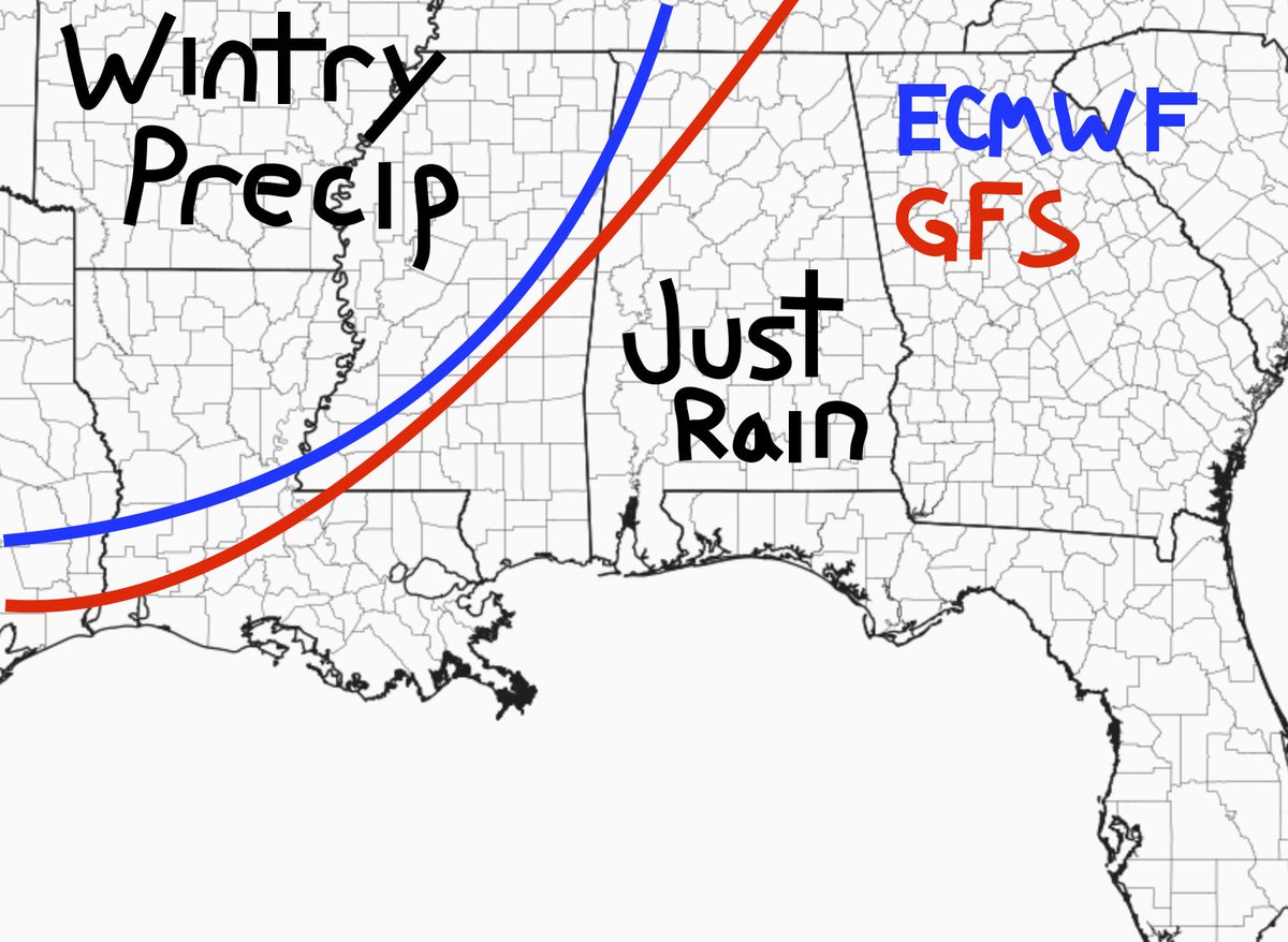
The above map is from the 00z data early Friday morning. Notice that despite their biases in the long run, in the short term, the delineation between rain and wintry precip is pretty close between the two models.
Taking a look at the 12z data, it shows a similar story


But I want to dive into the GFS data for a quick second to show how quickly the transition from snow to sleet/snow to sleet to rain will be.
Here is a quick look at how to get snow in the South from a post back in January!
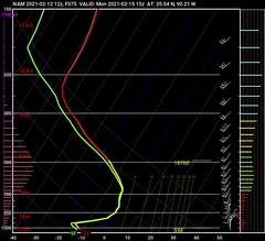
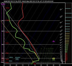
Here is the sounding data for near Memphis, TN

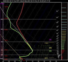
Here is the sounding from SE Arkansas, near Hamburg.

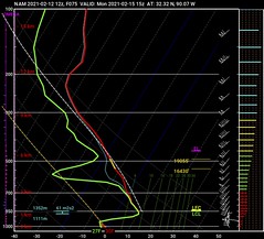
Here is the sounding from near Jackson, MS

Here is the sounding data from near Hattiesburg, MS.

Here is another look at those soundings as a GIF. In the same order. Memphis, Hamburg, Jackson, Hattiesburg.
Do those charts look weird? They are called Skew-T charts. Learn how to read a Skew-T here!
Graphically, you can see that Memphis will likely see snow since the entire column is below freezing. By the time you get to Hamburg it is mostly snow with some sleet as a sliver of the atmosphere looks to be above freezing. By Jackson it is mostly sleet, with some snow, as a good chunk of the atmosphere from 850mb to 700mb is above freezing. Then, by the time you get down to Hattiesburg, nearly the entire column from 700mb down is above freezing.
So, within this model, over the course of 250 miles, the atmosphere goes from all snow to all rain. And, more importantly, on the southern-most 80 miles of that span, you go from frozen precip and hazardous conditions to zero problems at all.
So, for a forecast for 72 hours from now, we are trying to pinpoint the difference in precipitation across the span of 80 miles.
That is like watching a NASCAR race from the International Space Station and trying to figure out when one driver shifts from 3rd to 4th gear when leaving pit road.
But amazingly, there is hope. And it comes from Tater Salad.

The NAM model – while it does show its bias at this point – can resolve with greater clarity the cold air closer to the surface as well as the potential for precipitation.
Take a look at the NAM data:
| Memphis | Hamburg | Jackson | Hattiesburg |
 |  |  |  |
Look at how shallow that cold air is on the charts. Very very close to the surface. That looks a fair bit different than the GFS data above. Particularly farther south toward Jackson and Hattiesburg. It flips things to a freezing rain event in Jackson snow farther north in Memphis and Hamburg.
Here is a look in GIF form moving from south to north.
And this is with a historically warm and dry bias.
Just as an aside…. The crazy thing is the Dendritic Growth Zone for Memphis in the 12z NAM is from about 550ft off the ground all the way up to nearly 19,000ft. That can make a TON of snow if there is enough moisture.
So the Warm and Dry NAM model lined up next to the Cold and Wet GFS model can start to give forecasters a good idea about where the middle ground may be. Along with the Warm ECMWF, you can start to put some puzzle pieces together to build a – hopefully – accurate forecast.
Nick, you said “answers” and so far all I have are questions
You’re right. I did say answers. But I wanted to walk you through everything first to help add some context to why my forecasts never look like any map you see floating around social media, and why my forecasts never sound like anything from the NWS, and at times my forecasts are shown using very rudimentary maps and simple graphics.
I put a lot of time and effort into these things and I try to make sure you guys have the best forecast given all – and. mean ALL – of the available data.
Right.
This forecast is given with the understanding that things may – and most likely will – change.
North of I-20
A snow-sleet mix is likely starting late Sunday night and into early Monday morning. Precipitation will start off light and spotty, and pick up in coverage and intensity during the morning on Monday. The farther north you go, the better the chance you switch over to all snow. In fact, by the time you get into Arkansas and up toward Memphis it will be all snow.
Within 30 miles north-and-south of I-20
This is going to be where the mess is. The farther west you travel, the more sleet and snow you will encounter. The farther east you travel the more rain you will deal with. So far it looks like the cold air will be running a diagonal line from about Lafayette, Louisiana to Huntsville, Alabama.
The transition line will fluctuate and wobble back and forth. So if you live in this area, you have the most difficult forecast to nail down.
And you will also have the most difficulty with the weather because if you travel two towns over, they may have drastically different conditions than you will.
More than 30 miles south of I-20
This area will see mostly just regular – very cold – rain. Occasionally sleet may mix in with the rain, but it will pose very little consequence as the temperature should remain above freezing while precipitation is falling.

Everywhere
Once the precipitation comes to an end – however it fell, frozen of liquid – cold air will push into the area and may pose a threat to sustain (or produce) icy roads. Even in the places that had liquid precipitation, the cold air may freeze that liquid before it can evaporate. That means ice and black ice may be a problem come Tuesday morning. And that may linger into Tuesday afternoon in places that don’t see much sunshine.
Temperatures Monday night will get down below 30 in most places, many spots will get down to around 25, north of I-20 will be closer to 20. And as you move toward Memphis, depending on the snowfall totals, expect to see temperatures below 20 degrees.
The Bottom Line
Colder air and precipitation are coming. Simultaneously. Some areas will see frozen precip while others will see only a cold rain. Please keep up with the forecast during the coming days as we continue to refine the numbers.
For now, for those living in South Mississippi, the closer you live to I-20 the better your chance is to see frozen precipitation (sleet) and the farther south you live, the less likely you are to see anything but a cold rain.


