
The National Hurricane Center is monitoring an area in the Gulf of Mexico for tropical development during the next five days.
And because it wouldn’t be an early season tropical system in the Gulf if it didn’t develop under weird circumstances, this one will involve the Central American Gyre working in cahoots with the remnants of Tropical Storm Amanda from the Pacific.
2020, am I right?
Model Data
The Amanda Show
Since this is a multi-faceted setup, let’s start with the easiest part: Tropical Storm Amanda in the Pacific.

Spaghetti plots (shown above) show the Tropical Storm drifting across central america and into the Bay of Campeche. It will likely get ripped apart by the mountains and only be a shell of its former self as it crosses land. IT is also likely to lose its low-level area of centralized circulation. As noted here by Dr. Kim Wood from Mississippi State:
Yeah, they track the low-level structure to maintain or change the name. The width of land plus topography in Mexico and most of Central America tends to destroy the low-level center and thus prevent the name from being kept. A recent crossover example was Otto in 2016: pic.twitter.com/nhuwMIvnCv
— Dr. Kim Wood (@DrKimWood) May 31, 2020
If that happens, Amanda dies, and whatever re-forms will be named whatever the next name on the list would be in the Atlantic.
Should it somehow hold onto an area of organized and centralized low pressure, it would remain Amanda. Giving us two “A” storms in the Atlantic this year.
Honestly, but not scientifically, since it is 2020, I feel like that is the most likely scenario. Any other year I’d say, “No way the area of low pressure survives!” but this is a really, really weird year.
I don’t mean to CAG, but…
While Amanda is the “easiest” part of the equation, the Central American Gyre is the most important. The broad area of low pressure is what will guide Amanda – or Amanda’s remnants around and into the Gulf. It is also going to offer the ‘nesting ground’ for thunderstorm activity to ramp back up once Amanda gets into the Gulf.
But forecasting the Central American Gyre’s behavior is not intuitive – nor easy – given its proximity to land.
And right now, model guidance is split. There are two main weather models that can look out that far, the GFS and the ECMWF.
The GFS computer weather model shows a broad, weak, and poorly organized area of low pressure developing and drifting north toward Texas before it falls apart. It brings some rain to the northern Gulf Coast, but that’s about it.
The ECMWF computer weather model redevelops the CAG / Amanda into a tropical system that is better organized and lifts it north to somewhere between Corpus Christi, Texas and Pensacola, Florida. The model also shows a very climatologically-typical CAG-related tropical system – lopsided and a heavy rain producer.
Morning ensemble data showed a wide variety of outcomes for whatever tries to develop.
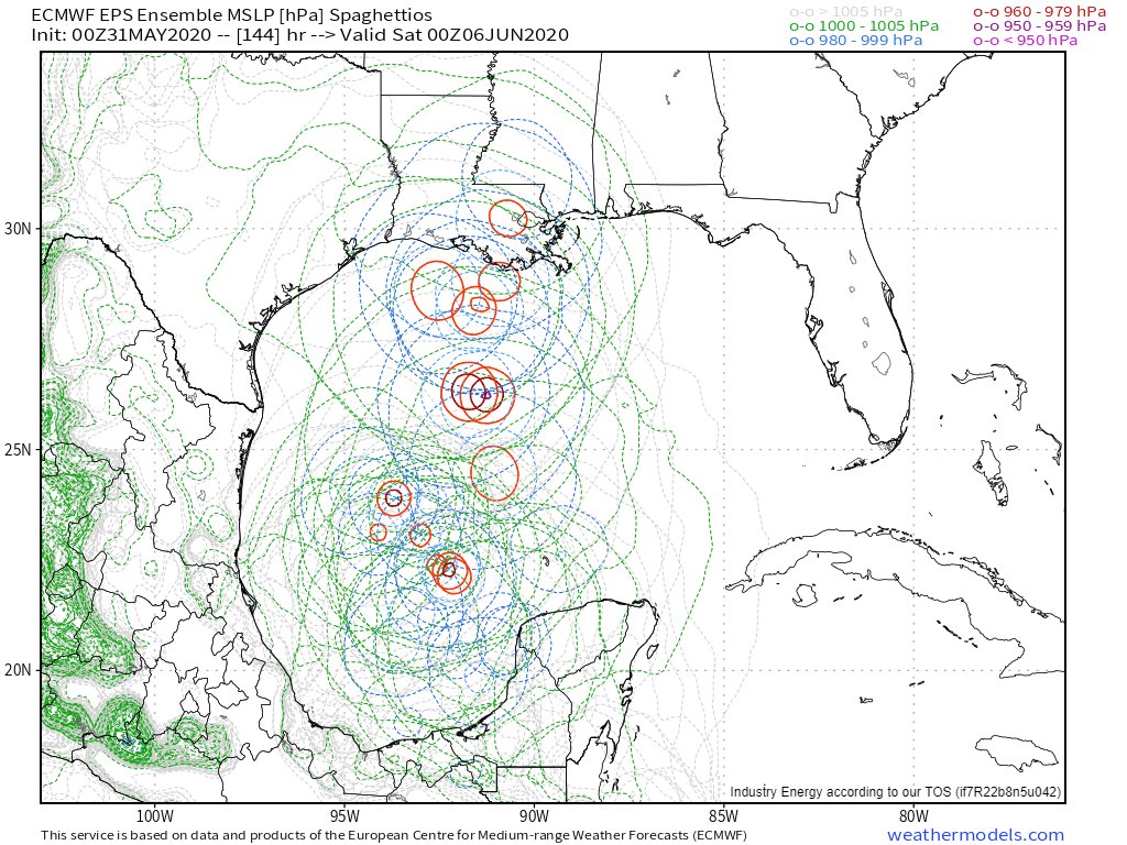
You can see from the above image that there is still a lot to be determined. Like we always say, we really start to learn more about what will eventually happen with tropical systems once the area of centralized low pressure forms.

But before then, it is difficult. And right now, we are still in the “before then” time frame.
That said, the available data from the ensembles does seem to agree that something will be in the Gulf by late next week.

The above image is the 00z GEFS model data showing a centralized area of low pressure – albeit weak – in the central Gulf by next weekend.
What does this mean for me, though, Nick?
At the end of the day, it depends on where you live and how things shake out. However, right now, I would say that if you live between Corpus Christi and Pensacola, you need to…
1. Start watching your local television meteorologist for forecast updates, checking with the National Hurricane Center every morning (you can read their updates on this website), or just check back here for updates, too.
2. Check your hurricane preparedness kit to make sure that your stocked up with supplies. In particular, water, food and medications. I know during the pandemic a lot of us are probably stocked up with extra supplies anyway, but double check those. For more info on what needs to be in your kit, head here!
3. Check out in your yard (if you have one) to see how you can mitigate your flooding risk. Usually these early season storms drop a lot – I mean, a LOT – of water. Some early estimates from the model data show the potential for some places to pick up over a foot of rain from whatever may drift north, regardless of strength. So take some steps now to look around your house and figure out what may help to move water away from your home and toward storm drains, creeks, or streams.


