The remnants of Tropical Storm Amanda in the Pacific are drifting north across part sof Central America and Mexico. As the remnant storms mix in with the Central American Gyre, the National Hurricane Center is watch sections of the Bay of Campeche for redevelopment.
If anything was to redevelop, it would get a new name.
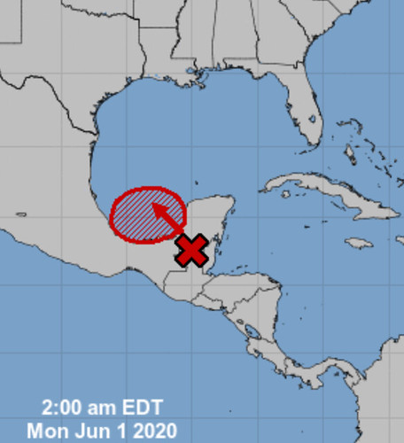
From the National Hurricane Center:
1. The remnants of Eastern Pacific Tropical Storm Amanda are currently located inland near the Guatemala-Yucatan Border. This large disturbance is forecast to move slowly northward this morning, followed by a northwestward motion later today, and the center of the low pressure system could emerge over the southeastern Bay of Campeche by this evening. If the remnants move back over water, environmental conditions appear conducive to support some development, and a new tropical depression could form while the system moves little through the middle of this week.
Regardless of tropical cyclone formation, heavy rainfall is likely to continue over portions of southern Mexico, Guatemala, El Salvador, Belize, and western Honduras during the next few days. For additional information on the rainfall threat, see products from your national meteorological service.
* Formation chance through 48 hours…medium…60 percent.
* Formation chance through 5 days…high…70 percent.
New data shows new crinkle
We will have to see how this pans out, but a crinkle in the new model data tonight leads to an interesting outcome for whatever happens in the Gulf.
On both the GFS and the ECMWF computer weather models, a ridge of high pressure develops across parts of the southern plains and drifts east across parts of the southeast. Doing what most ridges of high pressure do, it acts as a good blocker and, in the data, shows enough of a nudge to kick what ever is out there to the west and toward Texas.
And while, on the surface, that may seem like a “win” for Louisiana, Mississippi and Alabama, it may not be.
the problem with these Central American Gyre storms is that they are often messy and lopsided. The problem with early-seasons storms is they are often messy and lopsided. So, just because the center goes one direction, doesn’t mean the impacts go that direction, too.
And, at this point, there isn’t any data to suggest that the main impacts will only be there the center of the storm is.
Tropical Storm Cindy in 2017
Some of you may recall this system. This was the first storm, if memory serves me, to be given the “Potential Tropical Cyclone” designation. The center moved into Louisiana (the first named storm to make landfall in five years, at that point).
Here is a video from 2017 of some of the coverage.
As noted in the video above, while the center of the storm took a healthy jog west, the impacts were all across parts of southern Mississippi and southern Alabama.

Rainfall totals between 5″ and 15″ were tallied across the region, well away from where the center made landfall. It was the quintessential storm for “impacts aren’t always near the center.”
Bottom Line
While it is still too early for specifics, as the data continues to come in and model data becomes a bit more visible on social media with spaghetti plots being shared and everything else, I wanted to take a moment to remind everyone that sometimes those spaghetti plots can be accurate for the track, but not the impacts.
And – so far – the data has shown that no matter where this thing goes, Mississippi and Alabama end up with rainfall. And in some cases a fair amount.
But again, specifics are still not available. So please keep checking in with the NHC and here for updates


