The National Hurricane Center continues to monitor the remnants of Tropical Storm Amanda / Invest 93L as it enters the Bay of Campeche – associated witht eh Central American Gyre – in the southern Gulf of Mexico. The system will get better organized during the next 48 hours and the NHC gives it a greater than 70% chance of development.
There are a lot of moving parts here. So let’s start with the info from the NHC:
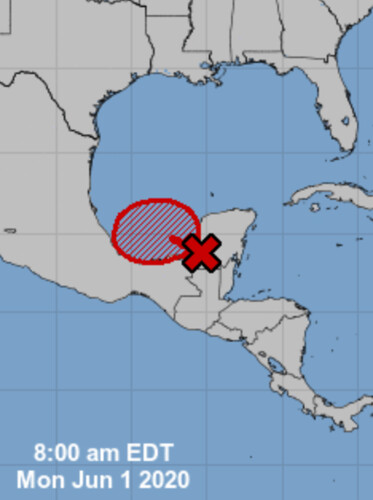
A large area of disturbed weather, associated with the remnants of eastern Pacific Tropical Storm Amanda, is located over the Yucatan peninsula of Mexico. This disturbance is forecast to move northwestward over the southeastern portion of the Bay of Campeche later today or tonight where environmental conditions are expected to be conducive to support development, and a new tropical depression is likely to form within within the next day or so. The system is then forecast to drift west or west-southwest over the southern Bay of Campeche through the middle of the week.
Interests along the coast of the Bay of Campeche should monitor the progress of this disturbance. Regardless of tropical cyclone formation, heavy rainfall is likely to continue over portions of southern Mexico, Guatemala, El Salvador, Belize, and western Honduras during the next few days. For additional information on the rainfall threat, see products from your national meteorological service.
* Formation chance through 48 hours…high…80 percent.
* Formation chance through 5 days…high…80 percent.
Model Data
Right now, most of the models have it reorganizing and drifting north toward the central sections of the Gulf. But after that point, the model guidance differs.
The interesting part about it moving into the central Gulf is that is where a blotch of warmer water exists – not only at the surface, but at depth. That means the storm will have access to more energy as it drifts north.
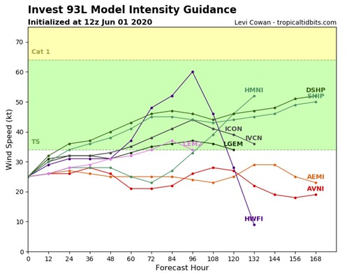
So when you look at intensity guidance for this system, keep that in mind.
Courtesy: Tropical Tidbits
Not that the HWF1 line on that map is the HWRF model and it – generally – does a decent job with intensity forecasting. And it shows Invest 93L gaining a lot of strength (from 30kts to 60kts of wind) in just 48 hours.
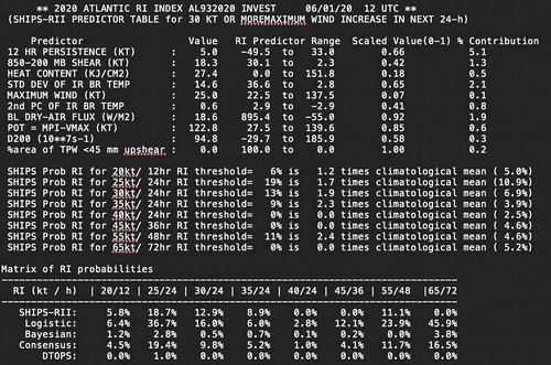
Adn that type of intensification is also shown in the SHIPS model guidance.
SHIP Intensity guidance // Courtesy: nhc.noaa.gov
Note that I’m not talking about “Rapid Intensification” to a Major Hurricane. But rather a increase in intensity from a Tropical Depression to a Tropical Storm.
Where is it going?
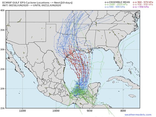
That is the Million Dollar Question. Guidance shows a wide range of possibilities at this point. But that is normal. Usually when systems are still just “Invests” they don’t ahve a localized area of low pressure for the models to “grab” and make a forecast. So each model “grabs” a slightly different spot. And when you start out in a different place, you end up in a different place.
That said, the ensemble guidance seems to be suggesting a similar path between the models.
Notice that both outcomes take the system north and then bend if back to the west toward Texas and Louisiana. This is due to an expected ridge of high pressure to build across parts of the south and guide the system back to the west as the ridge passes.
This may not mean that only Texas and Louisiana deal with impacts, though.
History
Some of you may recall this system. This was the first storm, if memory serves me, to be given the “Potential Tropical Cyclone” designation. The center moved into Louisiana (the first named storm to make landfall in five years, at that point). That system also bent back to the west and moved toward Louisiana and Texas after forming neat the Yucatan peninsula.
But guess who saw the most rain and most of the tornadoes?
Rainfall totals from Tropical Storm Cindy // Courtesy: nhc.noaa.gov
Rainfall totals between 5″ and 15″ were tallied across the region, well away from where the center made landfall. And Mississippi and Alabama saw most of the tornadoes from the system, too. It was the quintessential storm for “impacts aren’t always near the center.”
Because Central American Gyre storms are often lopsided and messy, it is important to keep in mind that where the center of the storm goes doesn’t mean ‘as much’ as with other types of tropical systems.
What can you do now?
At the end of the day, it depends on where you live and how things shake out. However, right now, I would say that if you live between Corpus Christi and Pensacola, you need to…
1. Start watching your local television meteorologist for forecast updates, checking with the National Hurricane Center every morning (you can read their updates on this website), or just check back here for updates, too.
2. Check your hurricane preparedness kit to make sure that your stocked up with supplies. In particular, water, food and medications. I know during the pandemic a lot of us are probably stocked up with extra supplies anyway, but double check those. For more info on what needs to be in your kit, head here!
3. Check out in your yard (if you have one) to see how you can mitigate your flooding risk. Usually these early season storms drop a lot – I mean, a LOT – of water. Some early estimates from the model data show the potential for some places to pick up over a foot of rain from whatever may drift north, regardless of strength. So take some steps now to look around your house and figure out what may help to move water away from your home and toward storm drains, creeks, or streams.
Author of the article:
Nick Lilja
Nick is former television meteorologist with stints in Amarillo and Hattiesburg. During his time in Hattiesburg, he was also an adjunct professor at the University of Southern Mississippi. He is a graduate of both Oregon State and Syracuse University that now calls Houston home. Now that he is retired from TV, he runs this site and its app in his spare time.