If you are enjoying this heat, get your fill of it today and tomorrow as things re going to change as we head into the weekend and through most of next week. Rain is back in the forecast, and based on the latest model guidance, there may be multiple rounds of rain possible.
Yesterday I mentioned ‘up to 6″ possible’ for some places and I think that still holds. Giving me a bit more confidence in that forecast is that the model guidance is actually showing such an outcome today.
The general pattern shows a parade of systems moving through the area as we head through the weekend and next week. The first one arrives on Friday, but won’t likely do much. The second system arrives on Saturday and gets hung up just off the coast.
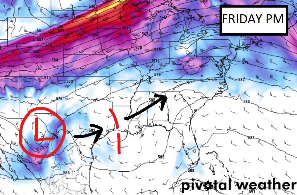
It will eventually move by, but Saturday and Sunday look to be rather damp. Currently model guidance supports hit and miss storms possible all day, both days. So it may rain in the morning for a while, then a bit more in the afternoon and then a bit more in the evening for some folks while others see just rain in the morning and others see just rain in the afternoon.
By Tuesday, the next system swings into the Plains from the Rockies. this should kick a cold front to the south that enhances the chance for storms from tExas through Arkansas, Louisiana, Mississippi Alabama and Tennessee. In fact, it will likely spark storms up through Missouri, Illinois and Indiana, too.
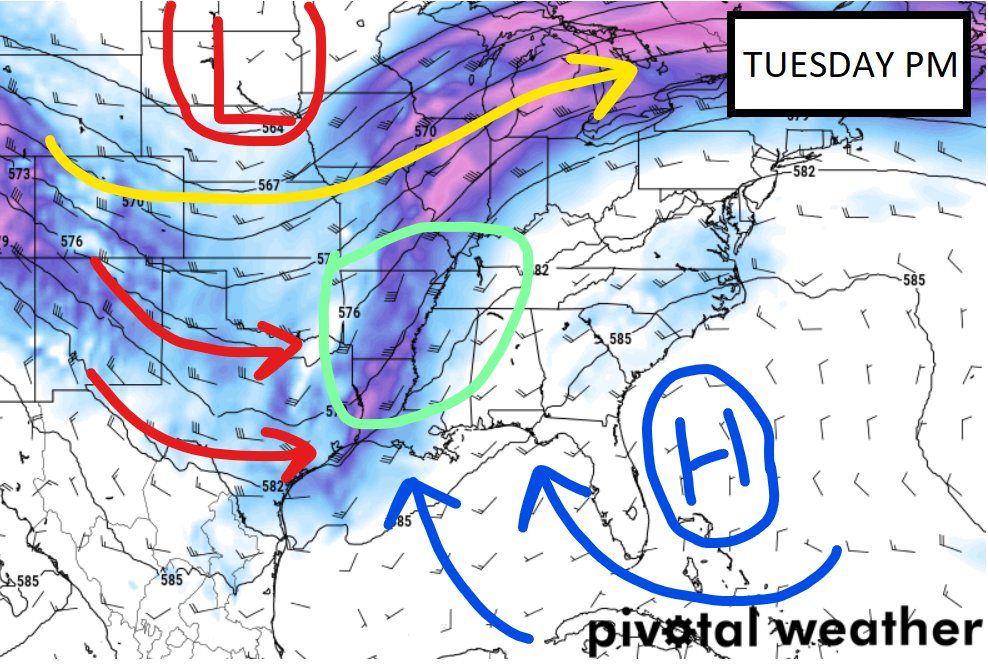
Because we will be closer to the Gulf moisture being pumped in by the ridge of higher pressure to the east, the front will push so far to the south, and the 500mb map shows the trough digging sufficiently far south… it would not surprise me if we have a low-end threat for severe weather on Tuesday.
On top of all of that, it looks like the potential for higher rainfall totals is increasing. The good news is that this is still slated to fall over multiple days which will mitigate any flooding risk. But we may see some brief, low-end, localized flash flooding at times this weekend and into next week underneath some of these storms that develop and drop a lot of rain quickly,
Looking at the models, remember to never look at them for accuracy with rainfall placement. Instead just use them as a guide for potential totals.
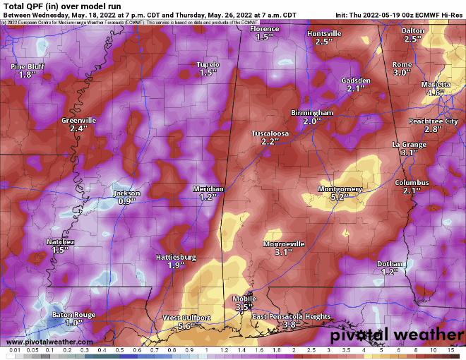
Totals shown across the models is currently between about 1.25″ and 6.5″ leaving a lot to be desired with respect to consistency, but that may actually end up being how things shake out. Some places that end up under the stronger storms end up with more rain, while others only get an inch or two.
Once we move into the end of next week, it looks like things will dry out a bit and we will get back into our normal summertime pattern with high pressure trying to take back over.
Day to Day Forecast
Today
Patchy fog this morning followed by mostly sunny skies this afternoon. Highs in the mid 90s.
Tonight
Mostly clear in the evening, then becoming partly cloudy. Lows around 70.
Friday
Mostly sunny with a storms possible, but certainly not likely.. Highs in the lower 90s. Chance for rain around 10-percent.
Friday Night
Mostly clear. Lows around 70.
Saturday
Mostly sunny with a chance for showers and storms. Some storms may be strong with brief heavy rain, lightning, gusty wind and small hail. Highs in the lower 90s. Chance of rain 60-percent.
Saturday Night
Mostly cloudy with more storms possible overnight. Lows around 70. Chance of rain 40-percent.
Sunday
Mostly cloudy with storms likely. Highs in the mid 80s. Chance of rain 60-percent.
Sunday Night
Mostly cloudy with storms ending by midnight. Lows in the mid 60s. Chance of rain 40-percent.
Monday
Mostly cloudy with more storms possible. Highs in the mid 80s. Chance of rain 40-percent.
Monday Night
Mostly cloudy. Lows in the upper 60s.
Tuesday
Partly sunny with more storms possible. Some storms may be strong. Very few, if any, will be severe. The main concern will be for heavy rain, lightning, gusty wind, and small hail. A tornado cannot be ruled out at this time. Highs in the upper 80s. Chance of rain 60- percent.
Tuesday Night
Mostly cloudy with rain ending by midnight. Lows in the upper 60s. Chance of rain 20-percent.
Wednesday
Partly sunny with a few afternoon storms possible. Highs in the upper 80s. Chance of rain 30-percent.


