The weather in CONUS is a tale of two worlds. Most regions west of the Rocky Mountains are sizzling with extreme heat well above normal for this time of year. With a lack of rainfall, localized areas are also witnessing elevated risks for fire weather. Meanwhile, in the central and eastern US, there is a moderate (3-out-of-4) risk of flooding for parts of Colorado, the Mid-South, and the Appalachian Mountains.

The upper atmospheric pattern can explain this dichotomy between weather in the West and in the East. Noticeably, winds are flowing counterclockwise over in the Northwest indicating a ridge of high pressure is over the region. This stifling pattern is not allowing any rain systems to develop, keeping the region exposed to the sun. On the other side of the rockies, there is a trough up in Canada which is providing a zonal wind flow at the bottom of the trough. This pattern is conducive for storms over the central and eastern US.
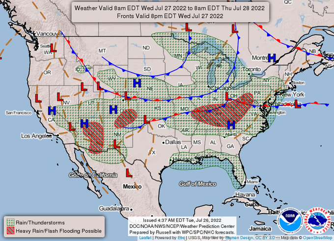

Looking at the surface, you can see clear signs of stormy weather east of the rockies which can be attributed to those slow-moving fronts in the middle of the country. Because these fronts are basically stalled out, they are and will continue to produce heavy rainfall from Colorado to the Ohio River Valley. Meanwhile, there is no stormy weather anywhere near the Northwest due to a lack of frontal systems in the region.
Northwestern heatwave induces elevated fire risk
Due to a lack of cloud cover, the Northwest is experiencing a substantial heatwave that will persist for the rest of this week before finally moving eastward over the weekend. This heatwave has prompted the issuance of several heat related watches, warnings, and advisories for communities from Northern California to Northern Idaho.


These heat-related NWS products are being issued for unusually warm conditions where heat indices will likely exceed 100F by the end of this week. This pattern continues to dry out the surrounding region which has led to the issuance of an elevated risk (1-out-of-3) for fire in a region that is already seeing above average wildfire activity. Additionally, the surrounding area could see isolated, dry thunderstorms which would produce the lightning required to start more wildfires.


Tomorrow and Friday appear to be the hottest days in the near future with heat indices peaking above 100F for Eastern Washington and Northern California as well as localized regions in Oregon. During these days, air temperatures will range from 15F-to-30F above average across large swaths of the Northwest, with a notable exception being central Idaho. Thankfully, over the weekend these air temperatures will begin to approach normal, and, by next week, below normal conditions could settle across coastal parts of the region.
Stalled fronts prompt flooding from Colorado to the Appalachian Mountains
Large frontal systems currently span the central and eastern US, but these meteorological features are not moving at a significant pace. As a result, moisture is being funneled along the stationary front, delivering rainfall for drought stricken parts of the Southwest, the Great Plains, and the Ohio River Valley. Unfortunately, because the front is stalled, this rainfall is piling up leading to a significant threat of excessive rainfall in states such as Colorado, Kentucky, and West Virginia.


According to the Weather Prediction Center, there is at a 40-percent chance of rainfall exceeding local thresholds in Colorado, Kentucky, and West Virginia. This is bad news, especially for the Appalachian Mountains which were already under a moderate risk (3-out-of-4) of excessive rainfall. Flooding is likely in these areas and is possible for larger regions such as the Southwest and the Mid-South which are under a slight risk (2-out-of-4) of excessive rainfall.

By the end of Saturday, rainfall totals could reach as high as 3.5″-to-5″ of rain in local parts of Kentucky, West Virginia, and New Mexico. Most of these states’ communities will see rainfall totals ranging from 1″-to-3.5″. Additionally, these rainfall totals are possible in most states in-between Colorado and Kentucky. If you live in any of these states, remember to “Turn Around, Don’t Drown” when you come upon a flooded roadway.
Heatwave likely for Midwest starting next week
The heatwave currently in the Northwest will slowly migrate eastward starting this weekend as the trough currently over eastern Canada moves out and is replaced by a ridge. This shift could lead to a staggering heatwave in the Midwest by the middle of next week as heat indices soar into the 100s.


The likelihood of excessive heat is high for August 3rd and 4th in the Upper Mississippi River Valley, according to the Climate Prediction Center. Because the high pressure system is forecasted to maintain strength as it migrates from the Northwest, there is a 60-percent chance of conditions warm enough to trigger the issuance of heat advisories and excessive heat warnings. While the Midwest will see the brunt of this brutal pattern shift, the entire central and eastern US will likely see above average temperatures throughout the beginning of August. In fact, the only places that could possibly see below average temperatures are Arizona and the Pacific Northwest.


The worst of the potential heatwave will likely happen on Wednesday and Thursday of next week, where indices could near 110F in several locations across the upper Midwest and upper Great Plains. These heat indices will be prompted by air temperatures that are upwards of 20F-to-30F above normal. Because there is a likely chance that this heatwave will occur, Midwestern residents should begin to take the proper precautions to prepare for excessive heat. Follow the material provided on Ready.gov when preparing for extreme heat.


