We have a few showers and storms dotting the landscape this morning. Mother Nature may have been a been alarm clock to some of you early-risers.
As we move through the day today, rain will be on-and-off with the potential for a severe storm. The Storm Prediction Center has parts of the Louisiana and southwestern Mississippi in a Slight Risk, elsewhere a Marginal Risk is in place. That is a “2” and a “1” on the 1-to-5 scale where “5” is the highest risk for the most significant severe weather.
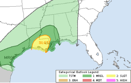
The “upgrade” to a Slight Risk is something I wrote about yesterday and expected to see today. This doesn’t mean the forecast has changed much, nor have the parameters gotten worse. I think the SPC wanted to make sure that things were going to pan out the way the models were projecting before moving to a Slight Risk today. This setup is not a very easy one to grab ahold of.
On top of that, we are looking at the chance for more rain. shorter-range Model guidance is showing 2″ to 5″ of rain across our area with the highest totals to the Northwest. This would spare most of the area from damaging flash flooding
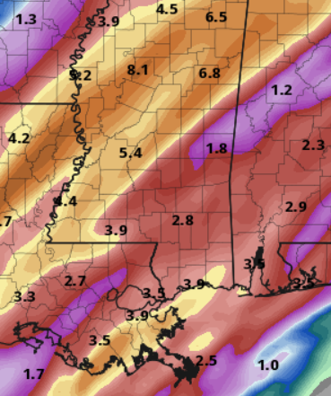
That said, the Weather Prediction Center has maintained the Moderate Risk for flash flooding across most of the area. And given the recent model guidance, I think many folks will see a Flash Flood Warning for their location or nearby before the day of over.
Looking at some of the high-res guidance that came out a few hours ago, Im starting to get a bit more concerned for parts of southern Mississippi and southeast Louisiana for some considerable flooding.
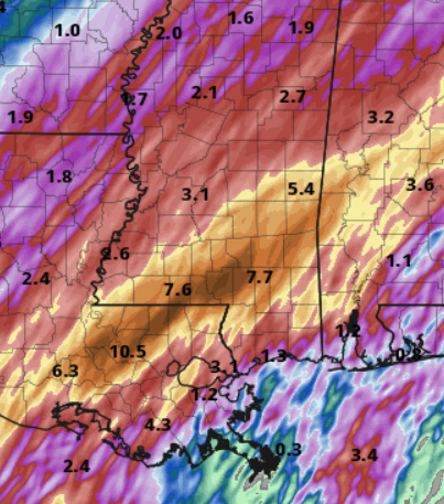
The HRRR model (shown above) shows a stripe of 10″ to 15″ of rain from East Baton Rouge Parish in Louisiana to the northeast through Covington County, Mississippi. I’m not sure I’m fully onboard with that amount of rainfall, but even half of that would be a meaningful amount.
A 10″ to 15″ rainfall event for T this area and would be similar to other big flooding events like March 2016 and December 2018. So please make sure if it starts raining heavily outside that you keep tabs on local low-lying areas and nearby streams and creeks.
REGIONAL DAY TO DAY FORECAST
Wednesday: Patchy fog in the morning. A chance of thunderstorms. Showers. Highs in the lower 70s. Southeast winds around 10 mph with gusts up to 20 mph. Chance of rain 80 percent.
Wednesday Night: A chance of thunderstorms. Showers. Lows in the lower 60s. Southeast winds around 10 mph. Chance of rain 90 percent.
Thursday: Showers with a chance of thunderstorms. Highs in the lower 70s. South winds 5 to 10 mph with gusts up to 20 mph. Chance of rain 90 percent.
Thursday Night: Showers likely with a chance of thunderstorms. Lows in the lower 60s. South winds around 5 mph. Chance of rain 70 percent.
Friday: A chance of thunderstorms. Showers. Highs in the lower 70s. Chance of rain 90 percent.
Friday Night: Mostly cloudy. A chance of showers with a slight chance of thunderstorms in the evening, then showers likely with a chance of thunderstorms after midnight. Near steady temperature in the lower 60s. Chance of rain 70 percent.
Saturday: Mostly sunny. Showers likely with a chance of thunderstorms in the morning, then a slight chance of showers and thunderstorms in the afternoon. Highs in the lower 70s. Chance of rain 60 percent.
Saturday Night: Mostly clear in the evening, then becoming partly cloudy. Cooler with lows in the upper 40s.
Sunday: Mostly sunny. Cooler with highs around 60.
Sunday Night: Mostly clear in the evening, then becoming partly cloudy. Cooler with lows in the upper 30s.
Monday: Sunny. Highs in the lower 60s.
Monday Night: Mostly clear. Lows in the mid 30s.
Tuesday: Sunny. Highs in the mid 60s.


