The rain overnight has ended and we are left with just drizzle and mixed cloud cover this morning. We will see off-and-on rain today. Nothing major anticipated, simply keep an umbrellas handy and get ready to use the windshield wipers.
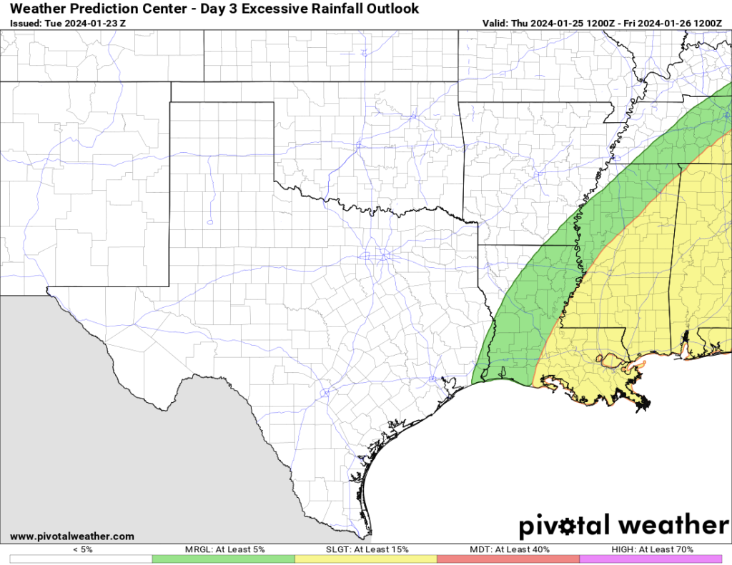
Looking ahead to tomorrow and Thursday, we have a few things to keep tabs on. The Weather Prediction Center has outlined parts of the area with a Moderate Risk for flash flooding for tomorrow with up to 8″ of rain possible in some spots. Then a Slight Risk is in place for Thursday.
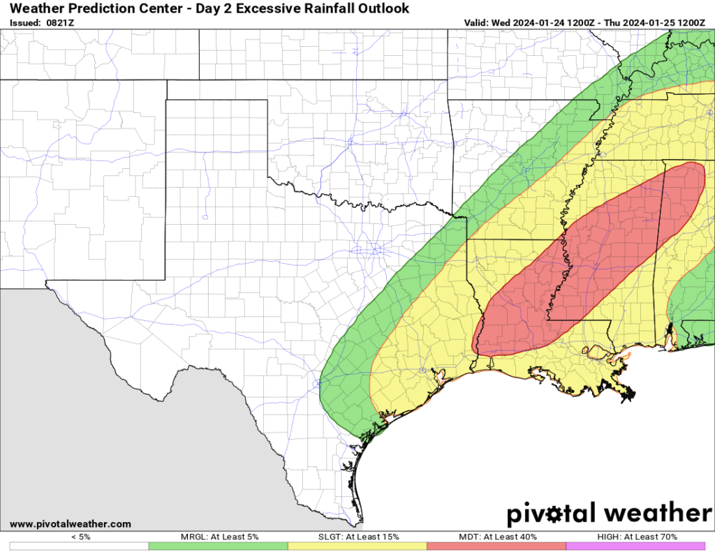
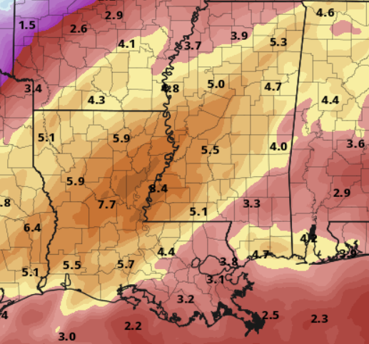
The WPC rainfall estimates show most of the heaviest rain will be to the west, but they also note (and I agree) that the specific location of the highest rainfall totals will be difficult to forecast for this event.
On top of the potential for flash flooding, we will also have the risk for some severe weather. I will say, it does look like this setup isn’t going to be quite as conducive for severe weather, but the potential isn’t zero, either.
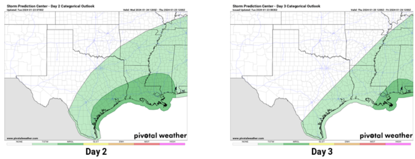
The Storm Prediction Center has highlighted the area with a Marginal Risk for severe weather for both Wednesday and Thursday
It wouldn’t surprised me if they add a Slight Risk area for Wednesday across parts of southeastern Louisiana and southern Mississippi, but I that doesn’t mean the forecast will have changed much. It looks like the biggest concerns (outside of the flooding) will be for lightning, wind gusts up to 65mph, small hail and the chance for a few brief tornadoes.
Looking at some of the guidance, if tornadoes can develop they will have a fair bit of shear and helicity to work with, but won’t have much instability. So, I think the top-end for tornado strength would be EF-2. Those will be strong enough to do some damage to trees and homes, but aren’t the big brothers that clear out entire neighborhoods.
Beyond that, things start to clear out through the weekend and we get back to normal as we start next week.
REGIONAL DAY TO DAY FORECAST
Tuesday: Cloudy with a 40 percent chance of showers. Highs in the upper 60s. Southeast winds 10 to 15 mph with gusts up to 25 mph.
Tuesday Night: Cloudy with a chance of showers. A slight chance of thunderstorms after midnight. Lows around 60. Southeast winds 10 to 15 mph with gusts up to 25 mph. Chance of rain 50 percent.
Wednesday: Cloudy. A chance of showers with a slight chance of thunderstorms. Severe weather can’t be ruled out. Highs in the lower 70s. Southeast winds 10 to 15 mph with gusts up to 30 mph. Chance of rain 80 percent.
Wednesday Night: Showers with a chance of thunderstorms. Patchy fog. Near steady temperature in the mid 60s. South winds 10 to 15 mph with gusts up to 25 mph. Chance of rain 60 percent.
Thursday: Showers. A chance of thunderstorms and some may be severe. Highs in the lower 70s. Chance of rain 70 percent.
Thursday Night: A chance of thunderstorms. Showers likely. Lows in the upper 50s. Chance of rain 70 percent.
Friday: Mostly cloudy. Showers likely with a chance of thunderstorms in the morning, then a chance of showers with a slight chance of thunderstorms in the afternoon. Highs in the lower 70s. Chance of rain 70 percent.
Friday Night: Mostly cloudy. A chance of showers with a slight chance of thunderstorms in the evening, then showers likely with a chance of thunderstorms after midnight. Near steady temperature in the lower 60s. Chance of rain 60 percent.
Saturday: Mostly cloudy in the morning, then becoming partly sunny. A chance of thunderstorms. Showers likely, mainly in the morning. Highs in the lower 70s. Chance of rain 30 percent.
Saturday Night: Partly cloudy in the evening, then becoming mostly cloudy. A slight chance of thunderstorms in the evening. A slight chance of showers. Cooler with lows around 50. Chance of rain 20 percent.
Sunday: Mostly sunny. Cooler with highs in the lower 60s.
Sunday Night: Partly cloudy. Cooler with lows around 40.
Monday: Sunny. Highs in the upper 50s.


