As we enter July, let’s take a brief moment to look at the month of June weather-wise.
June was a very dry month across most of the United States, with an extreme exception of the Desert Southwest. Since the monsoon started earlier than usual, there are some sites that have recorded over 600% of their average June precipitation.
Below is a percent-of-average map for the month of June, created by Brian Brettschneider.

South Texas stands out as a region particularly hit by short-term drought, receiving under 25-percent of their average precipitation this month.
Looking at the future, now, Invest 95L will help to alleviate some of the drought over SE Texas, but most of the state will remain under drought conditions.

Taking a look at the satellite imagery from last night, we can see the Invest bringing thunderstorms to TX, LA, and MS. This is one of the main features across the US currently. Storms also formed over the Great Plains, with some severe weather over Kansas.
Strong storms are expected to return across the High Plains and Missouri Valley this afternoon, below is the SPC Outlook for today.

These storms are being caused by a weak disturbance in the upper levels. The ridge makes it hard for systems to dive South, which is what causes severe weather in the Plains and Southeast, but right now it’s going to just pass around the edge of the ridge.

The flow is mostly zonal, or West to East. Zonal flow doesn’t generate a lot of vorticity, which is responsible for causing disturbed weather. Until this changes, we’re going to see mostly calm weather across the CONUS.
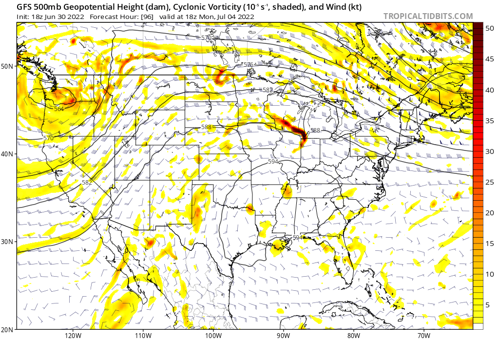
Skipping ahead to Monday, we see a strongly amplified flow-that is to say, large looping patterns in the flow that generates a lot of vorticity. The large trough is centered over the Pacific Northwest.
What this means is that the West Coast will see more rain, and cooler weather.
Meanwhile, the South is under the influence of a ridge, so there will be hot weather and lower rain chances.
Another feature to watch- There is a red mark, or vorticity maxima near Chicago, IL. This indicates a small shortwave trough rotating around the upper level ridge.
What this means is that the area from Chicago to Washington DC will have to be keeping an eye out for an MCS next week-or perhaps multiple. Some strong winds may be possible depending on the exact trajectory and conditions.
Looking at some of the predictions for the next few weeks, this represents what the ridge is going to do long term.

Heat is very likely to continue across the Western 2/3 of the CONUS, through the next 2 weeks. Not much is set to change under the big ridge, as it’s too strong to allow any systems in the country.
Drought is expected to continue across the South, another consequence of the ridge.
Looking to the Desert Southwest, we’re going to see the monsoon continue over the next week.
It’s been largely focused on Arizona, but we’re going to see the axis of heavy rain shift East, further towards New Mexico. Flash flooding is likely in the rough terrain of the Southwest, as the very heavy rains are set to continue.

The 7 day forecast rainfall map shows everything we’ve talked about- Not much rain for Central Texas, enhanced rain over New Mexico and the Pacific Northwest, and a streak over Northern Illinois indicating potential severe storm activity.
Lastly, the bit I mentioned last week about the tropics is becoming more clearer. We’re definitely about to see a lot less activity. After Invest 94L, and the system, behind it, the wind shear is going to increase across the Atlantic, and the storms are probably going to stop forming, for just a bit. Check in on this morning’s tropical update for more information!


