At this time of year in 2021, the North Atlantic was at five named tropical cyclones while, in 2020, the North Atlantic had already produced four named tropical cyclones. Comparing these two hyperactive seasons with the 2022 Atlantic Hurricane Season and there is a notable decrease in organized systems.
The 2022 season has tried to keep pace with the last few seasons; however, the activity has not resulted in organized, named storm systems. In fact, Tropical Storm Bonnie just formed today. Additionally, the two other disturbances that the National Hurricane Center is monitoring have a decreasing likelihood of forming organized systems over the next five days.
Using water vapor imagery, the North Atlantic appears busy with a disturbance off the coast of Texas, another one east of the Lesser Antilles, and Bonnie in the Caribbean Sea east of Central America; additionally, there are a couple African Easterly Waves off the coast of Africa. However, note in the loop shown above that the Gulf of Mexico disturbance is dissipating, and the disturbance heading towards the Lesser Antilles is broad and surrounded by dry, dust-filled air.


As the NHC notes, disturbances 1 and 2 are unlikely to develop while PTC 2 should develop into a tropical storm directly before landfall in Nicaragua. Though probabilities for development are generally decreasing, storm hazards remain relatively the same. Southeast Texas can expect relatively high rainfall totals while Nicaragua will see tropical storm force winds and heavy rain from Tropical Storm Bonnie.
Tropical Storm Bonnie
According to the NHC, aircraft reconnaissance did a centralized area of closed low pressure. They also detected maximum sustained winds of 40mph; as a result, we get a named storm.
The above IR visualization from GOES-16 shows localized convective bursts indicated by the dark grey and pink color scheme. This is a sign that Bonnie is intensifying as it reaches the warm water of the western Caribbean Sea.


Winds are still expected to be tropical storm force upon landfall in Nicaragua tonight. Therefore, if you have family in that region, check-in with them to make sure they are prepared in case they lose electrical power. After a landfall in Nicaragua, Bonnie is expected to make it to the Pacific where it will continue to strengthen as it travels northwestward.
Disturbance 1 (Invest 95L)
Invest 95L, a disturbance in the Gulf of Mexico, had peaked at a medium probability of development yesterday as convection began to intensify. However, the convection was not close enough to the center of circulation; as a result, Invest 95L could not gain tropical depression status. Additionally, this convection was short-lived as shear present within the environment tilted and disrupted the updrafts and downdrafts needed to sustain convection.
As the IR imagery shows, the system meandered northward overnight, reaching the Texas-Louisiana border and reducing its runway for development. Combined with a lack of convection, Invest 95L lost its chance to develop. A lack of development, however, does not mean the system won’t impact southeastern Texas and southwestern Louisiana.
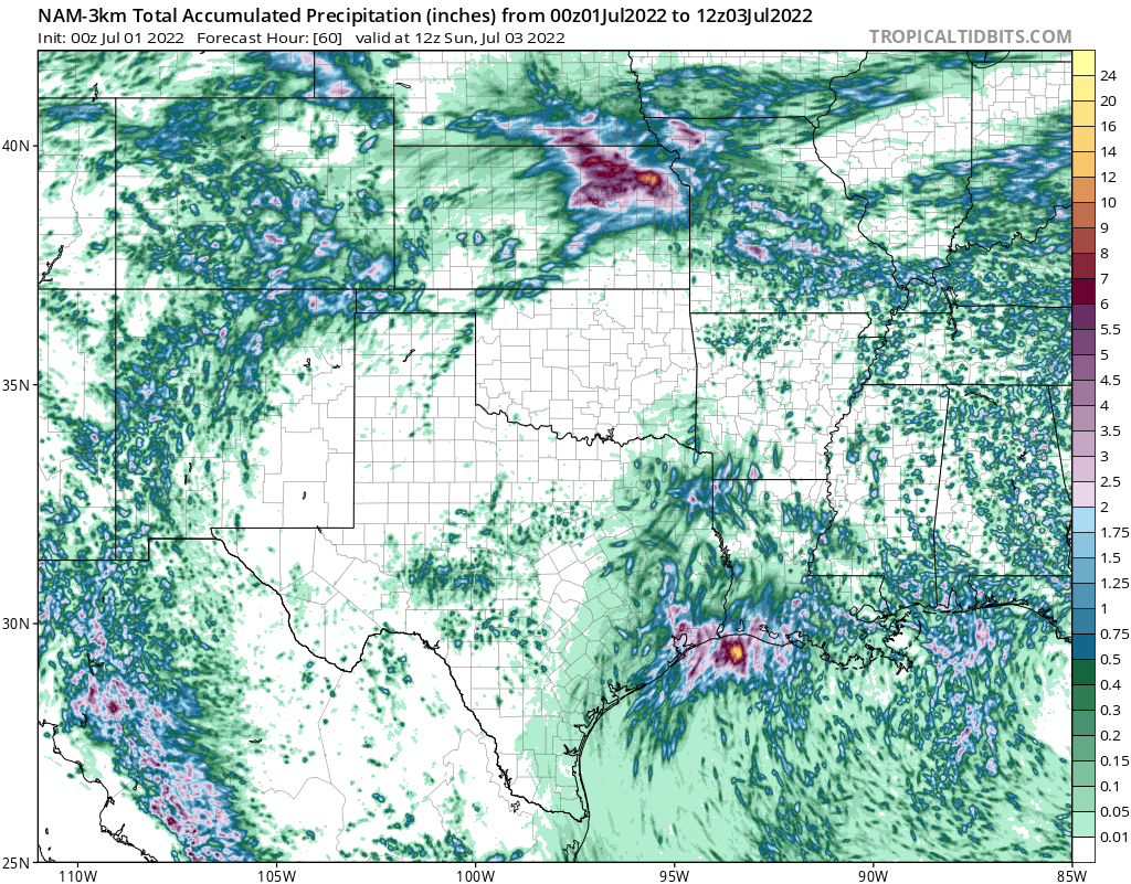

Though wind will not be a major hazard with this system, locally heavy rainfall totals from 4″-to-6″ could cause flooding. This threat has been acknowledged by the Weather Prediction Center which issued a 2 out of 4 risk of excessive rainfall in southeastern Texas and southwestern Louisiana.
Disturbance 2
Disturbance 2, which is located east of the Lesser Antilles, has a very low possibility to develop; the National Hurricane Center gives the system a 10-percent chance of development over the next 48 hours. This window for organization is closing quickly, however, as the system progresses into a hostile environment this weekend.
The IR imagery illustrates that disturbance 2 does not have a local center of circulation but instead has multiple swirls and a broad counterclockwise rotation. Additionally, while there is more convection than in Invest 95L, there are no convective bursts showing that the system’s development is stagnant. With this system being so disorganized, it is not forecasted to survive the hostile environment ahead of it.

The future environment for disturbance 2 will be full of dust that will choke out the little bit of convection that is churning at the moment. As shown in the water vapor imagery above, the dark grey mass represents the Saharan Air Layer (dust) north of the disturbance. As the system travels northwest, this dust will enter the system disrupting convection and destroying the storm.


