Looking back through the records, I wanted to find if there were any past events that looked like the current one coming up on Sunday and into Monday. And for that, I turn to the CIPS Analogs!
Usually, CIPS comes in handy for looking out for severe weather. But it is applicable across the entire meteorological spectrum – snow, heat, cold, storms, you name it! And history is important in weather because pattern recognition is a big part of meteorology.
To the history books!
Some of you may recall, a few days ago, when I mentioned that this setup, historically, is a favorable setup for severe weather. And, if were were a bit warmer, that would be something I’d be talking about and not snow.
So I took a peek. And sure enough.
That date sounded familiar. And I said, well, once I’m done with looking for snow, I’ll circle back. And I moved over to the snowfall section. I wanted to see if the Top 15 most similar situations like this one ever produced snow… And it turns out, one did.
That little splotch of blue in central Mississippi is helpful, but it isn’t where the research ends.Because, let’s be real, that isn’t really close enough to South Mississippi to make any determinations about what happened here.
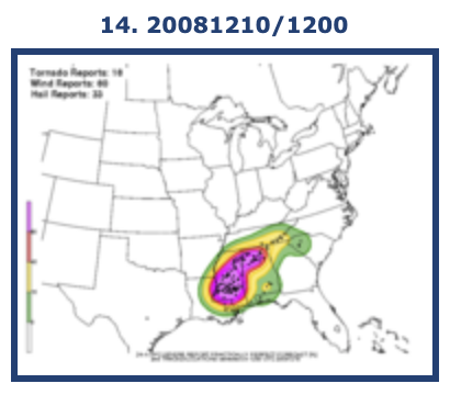
So, you check the data and compare. The date was 20081210 – or 12/10/2008. The same date as the severe weather shown above!
Now wait just a second!
You mean to tell me the area had tornadoes and snow on the same day?!
Not quite, but close. A round of severe weather rolled through and then shortly after that a batch of snow blanketed the area.
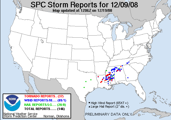
The storms were from mid morning on 12/9 through early morning on 12/10. Then late on 12/10 and into 12/11 the snow arrived.
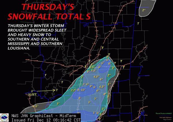
Snowfall totals of 1″ to 3″ west of I-59 were pretty widespread. Totals of 3″ to 5″ were pretty common, too.
That is something I would expect to see in Kansas, Oklahoma or Texas – not Mississippi.
So how much does it look like that could happen?
Not likely, but not impossible.
Looking at the maps, it seems like many of the pieces are in similar places with this go-around compared to the one mentioned above. The main difference is the strength of the area of low pressure.
But this situation is the No. 14 analog. So, it made the like of the Top 15. So we can’t just ignore it, but let’s poke into the data and see how it scored.

It is ranked No. 14 and has a score of…. 2.9/15. That is, like, 19-percent. Not great. Usually you want to see scores close to 12 or 13, not 2.9.
But when you poke around inside that data, the reason it failed so badly is because it is so much cooler leading into the event. All the puzzle pieces in the upper atmosphere are in – roughly – the same place. The big difference is the temperature from 4,000ft down is so much colder it scored numbers like 0.034 and 0.223. But we are getting a bit into the weeds now.
I know, I know! I should have warned you with a “Nerd Alert!” but, the point is that with all the pieces in similar places, it means a similar outcome is still possible. But the placement just may be different.
The Bottom Line
We are starting to get a better idea about how things are going to shake out. This forecast can still change, but it looks like this should (emphasis on should, here) for the most part hold.
Overview
I think that given the latest model data and how it stacks up with past events, there is support for snow somewhere in South Mississippi. That said, it may be mixed in with a lot of rain. and accumulating snow still isn’t likely.
Can sticking snow be ruled out completely? No. I still think there is a chance. But it is a small one.
The most likely scenario is one that includes a lot of rain, some rain mixing with snow and sleet at times. And a changeover for some – especially in Lawrence, Jeff Davis, Simpson, Smith and Jasper counties, as well as points north and west – to all snow or all sleet for short bursts of time.
Thundersleet (also a great Metal band name) is still possible, though also looking less likely.
Timeline
Precipitation starts to fall Sunday night about 9p for some. For others, precipitation will wait until after midnight. The first rounds will be light. and likely all liquid.
By Monday morning around 7a, rain will be falling across the entire area. It may be heavy at times and temperatures will be around 35 to 40 degrees. In the heaviest rain showers, snowflakes may periodically mix in.
By Monday afternoon around 1p, rain may begin to mix with sleet for some – mainly north and west.
By Monday evening around 7p, rain will be ending and leftover drizzle and light sleet may persist. A few flurries may be possible across the northern areas along I-20.
What to expect
Some organizations and businesses make may schedule changes to prepare for wintry weather. Schools may make preparations, too. Government offices may also change their hours and availability.
People are likely to buy up bread and milk – and if 2020 taught us anything, toilet paper. The grocery store may be busy this weekend.
In South Mississippi travel isn’t likely to be impacted by frozen precipitation, but roads will be wet so give yourself extra time to get from Point A to Point B. If you have to travel along, or north, of I-20 on Monday prepare for the potential for icy conditions and slower travel.
If you have a flight out of PIB, NOLA, Gulfport, or Mobile any time on Sunday or Monday it won’t be affected by frozen precipitation on the ground. If you have a flight out of Jackson or Meridian, your flight may be delayed (but likely only shortly) depending on how things shake out. Check with your airline before leaving home.


