Snow is still in the forecast for some areas in the South Sunday/ Monday. So, I figure it is time for another round of everyone’s favorite game… (read this like the people scream “Wheel! Of! Fortune!”)
WILL! IT! SNOOOWWW!!!
Now for the star of the game…. The guide!
I came up with a guide for everyone in the South to use to figure out if the model data supports seeing any snow flying around in the air. Perhaps a model map shows “blue” in your area… But that isn’t always the whole story. Sometimes it can snow in the “green” area. Other times it will rain in the “blue” area.
This can’t help you figure out if snow will “stick” or “accumulate” but it can help you figure out if you will see visible snow in the air.

Now, in order to use this guide you’ll need to be able to look at some model data. You’ll need access to a Skew-T and a few model maps like the 700mb Vertical Velocity map.
Using the guide for five areas
Using the above guide, we can quickly look at some Skew-Ts and figure out if the raw data support the chance for any wintry precipitation. This goes beyond just looking at the precip maps and does a better job at identifying the potentials.
Monroe, LA
Looking at the latest HRRR data for Sunday night at 11:59pm, here is what the Skew-T looks like:

Step 1:
Moisture? Yes! The green line is on top of the red line! And almost all the way from the bottom to the 500mb line.
Step 2:
Forcing? Plenty!
Omega? Yes! And within the Dendritic Growth Zone.
Step 3:
Dry Air? Nope!
Step 4:
Warm Air layer? Nope! The red line is to the left of the blue-dashed 0C line on the whole graph
Step 5:
Precipitating? Snow!!!
Baton Rouge, LA
Looking at the latest HRRR data for Sunday night at 11:59pm, here is what the Skew-T looks like:
Step 1:
Moisture? Yes! The green line is on top of the red line! And almost all the way from the bottom to the 500mb line.
Step 2:
Forcing? A fair amount in the mid-levels!
Omega? Yes! And within the Dendritic Growth Zone.
Step 3:
Dry Air? Nope!
Step 4:
Warm Air layer? Totally. the temperature is around freezing at the 700mb line but warms to 5C by 850mb and stays above freezing the whole way down to the ground.
Step 5:
Precipitating? Rain. No Snow 🙁
Jackson, MS
Looking at the latest HRRR data for Sunday night at 11:59pm, here is what the Skew-T looks like:

Step 1:
Moisture? Yes! The green line is close to the red line!
Step 2:
Forcing? A fair amount in the mid-levels!
Omega? Some. And within the Dendritic Growth Zone. But none below that.
Step 3:
Dry Air? A sliver of dry air down between 925mb and 850mb.
Step 4:
Warm Air layer? At this point in time, no. It looks like the entire column is at or below freezing.
Step 5:
Precipitating? Snow!!!
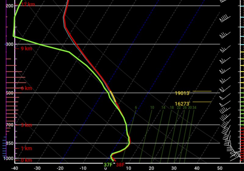
Laurel, MS
Looking at the latest HRRR data for Sunday night at 11:59pm, here is what the Skew-T looks like:’

Step 1:
Moisture? A good bit. But there is some dry air lower down in the column. Though, for the most part, the green line is close to the red line!
Step 2:
Forcing? Not as much.
Omega? Very little between 925mb and 850mb and then again above 500mb. But none within the Dendritic Growth Zone.
Step 3:
Dry Air? A fair bit down between 925mb and 850mb.
Step 4:
Warm Air layer? Between 925mb and 850mb there is a plume of warmer air.
Step 5:
Precipitating? Maybe Snow ¯\_(ツ)_/¯
Mobile, AL
Looking at the latest HRRR data for Sunday night at 11:59pm, here is what the Skew-T looks like:’

Step 1:
Moisture? Some within the DGZ. But there is some dry air lower down in the column between 600mb and 850mb. Though, for the most part, the green line is close-ish to the red line!
Step 2:
Forcing? Not as much.
Omega? A little through the column. Mainly between 925mb and 700mb. Only a sliver within the Dendritic Growth Zone.
Step 3:
Dry Air? Some between 600mb and 850mb.
Step 4:
Warm Air layer? Yes. From the surface up to 750mb there is a plume of warmer air.
Step 5:
Precipitating? Rain. No Snow 🙁
The Bottom Line (for South Mississippi)
So far, it looks like the best chance for snow will be north and west for late Sunday night and into early (super early) Monday morning. But there may still be a chance for some snow to fly in South Mississippi as the atmosphere moistens up. It will be cool enough still that snow may make it all the way down to the surface at times.
Overview
Beyond the timeframe of 11pm Sunday through 2am Monday, it looks like rain will be the dominant precipitation type for South Mississippi. I’ll have another post up later today with some more regional information (I know some of you guys aren’t in So Miss), but it looks like the best chance for snow will be north of I-20 in Mississippi and back across northern Louisiana.
Timeline
Precipitation starts to fall Sunday night about 9p for some. For others, precipitation will wait until after midnight. The first rounds will be light. and likely all liquid. But some spots may see snow falling at this time, too. It is going to be dependant on very short-term localized atmospheric conditions. Truly you could see snow and your neighbor five houses down may see rain.
By Monday morning around 7a, rain will be falling across the entire area. It may be heavy at times and temperatures will be around 35 to 40 degrees. In the heaviest rain showers, snowflakes may periodically mix in.
By Monday afternoon around 1p, rain may begin to mix with sleet for some – mainly north and west.
By Monday evening around 7p, rain will be ending and leftover drizzle and light sleet may persist. A few flurries may be possible across the northern areas along I-20.
What to expect
Some organizations and businesses make may schedule changes to prepare for wintry weather. Schools may make preparations, too. Government offices may also change their hours and availability.
People are likely to buy up bread and milk – and if 2020 taught us anything, toilet paper. The grocery store may be busy this weekend.
In South Mississippi travel isn’t likely to be impacted by frozen precipitation, but roads will be wet so give yourself extra time to get from Point A to Point B. If you have to travel along, or north, of I-20 on Monday prepare for the potential for icy conditions and slower travel.
If you have a flight out of PIB, NOLA, Gulfport, or Mobile any time on Sunday or Monday it won’t be affected by frozen precipitation on the ground. If you have a flight out of Jackson or Meridian, your flight may be delayed (but likely only shortly) depending on how things shake out. Check with your airline before leaving home.


