It is always a wild ride when trying to track the potential for snowfall in the south. The slightest wobble can really change things. And things tend to wobble back and forth almost every three to six hours within the data.
As I said a few days ago, as an analogy, model data for ‘high impact’ events more than three days ago can be a lot like a dog’s tail, wagging back and forth. And the furth out you go, the wilder the swings.
That means a lot of 2000’s Busta Rhymes for forecasters…
The closer in time you get to an event, you can start to pick up on trends. And it looks like one trend that has set up with the short-range HRRR data is to offer a better chance for snowfall across parts of south Mississippi.
Time to look at Data
Not like that. Model data!
…….. Weather model data.
Much better.
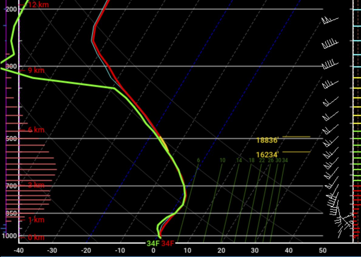
The above chart is a Skew-t chart of the temperature through the atmosphere for a single point in space and a single point in time. In this case, it is at 4am tomorrow morning at Bobby Chain Airport south of Hattiesburg.
The ‘Good News’ for snow-lovers…
Compare that chart with the one I posted yesterday or the day before and you can see that the column is more saturated (more moisture to make snow) and cooler (to keep snow as snow and not melt into raindrops).
So far, the Skew-T data from the HRRR model is still above freezing for 6,000ft of the atmosphere between about 3,000ft and 9,000ft up. And that is still going to be capable of melting a lot of the snow.
However, the data now shows temperatures only as warm as about 2C (or 36F) within that layer. So some snowflakes will likely survive. That means the model is suggesting a Rain/Snow Mix for this point in space and time.
We can go through The Guide for making snow in the south and you still get “Maybe Snow ¯\_(ツ)_/¯” but it is a bit closer to “SNOW!!!” than it was yesterday.
The reality for snow-lovers….
Before you set an alarm on your phone and plan to drive to the airport, please know that weather model data is not 100-percent accurate, 100-percent of the time. It isn’t even 75-percent accurate 50-percent of the time. It is guidance. And because of that, any specifics need to be applied generally.


In the above maps the place where the green shading butts up against the blue shading is there the atmosphere at about 4,000ft goes from above-freezing to below-freezing. And from left to right, the first map is at 7pm Sunday night, the middle map is at midnight, and the last map is at 4am (same time at the Skew-T chart above).
If you want to see snow, you want to be in the blue-shaded areas.
But that last darkest-shaded green area is also cold enough to let a lot of the snow make it through. Because it is hovering pretty close to the freezing point.
Of course, that isn’t the only model. Here is an animation of all of the model data we have access to looking at the temperature at 4,000ft, from each model, at 7pm Sunday night.
So, there are many different options and multiple variables to sift through.
The ‘Bad News’ for snow-lovers…
It looks like if you go to bed tonight and there are a few snowflakes mixing into the rain, the data doesn’t support waking up to snow on the ground.

Instead, based on the RAP model data, there is a better chance that we wake up Monday morning to a very cold rain and – perhaps even! – a few rumbles of thunder. And there may be a few sleet pellets mixed into the rain, too.
But by 7am, it looks like the Dendritic Growth Zone (where snow is made) will be drying out and all that is left is precipitation forming and falling from points in the atmosphere that are above freezing. That includes the temperatures at ground-level.
The forecast for you
While I can’t give a county-by-county forecast for the entire region, here is a look at the county-by-county forecast for South Mississippi.
Simpson County
7p – Precipitation may start as early as 7p. It will likely start as some form of a rain/snow mix – mostly rain. As precipitation increases in intensity, more snow will mix in with the rain and it may switch over to completely snow at times. Temperatures will be between 33 and 36.
1a – Precipitation continues as a rain/snow/sleet mix, flipping back and forth between all snow, all sleet, all rain, and a mix of all three. No meaningful accumulations are expected during this time. Temperatures will be between 33 and 36.
4a – Precipitation continues as a rain/snow/sleet mix, flipping back and forth between all snow, all sleet, all rain, and a mix of all three. Up to 1″ of a slushy accumulation is possible. Temperatures will be between 33 and 36.
7a – Precipitation changes back over to rain – all rain. Any accumulations melt as temperatures will be above freezing still. Temperatures will be between 33 and 36.
Smith County –
7p – Precipitation may start as early as 7p. It will likely start as some form of a rain/snow mix – mostly rain. As precipitation increases in intensity, more snow will mix in with the rain and it may switch over to completely snow at times. Temperatures will be between 33 and 36.
1a – Precipitation continues as a rain/snow/sleet mix, flipping back and forth between all snow, all sleet, all rain, and a mix of all three. No meaningful accumulations are expected during this time. Temperatures will be between 33 and 36.
4a – Precipitation continues as a rain/snow/sleet mix, flipping back and forth between all snow, all sleet, all rain, and a mix of all three. Up to 1″ of a slushy accumulation is possible. Temperatures will be between 33 and 36.
7a – Precipitation changes back over to rain – all rain. Any accumulations melt as temperatures will be above freezing still. Temperatures will be between 33 and 36.
Jasper County –
7p – Precipitation may start as early as 8p. It will likely start as some form of a rain/snow mix – mostly rain. As precipitation increases in intensity, more snow will mix in with the rain and it may switch over to completely snow at times. Temperatures will be between 33 and 36.
1a – Precipitation continues as a rain/snow/sleet mix, flipping back and forth between all snow, all sleet, all rain, and a mix of all three. No meaningful accumulations are expected during this time. Temperatures will be between 33 and 36.
4a – Precipitation continues as a rain/snow/sleet mix, flipping back and forth between all snow, all sleet, all rain, and a mix of all three. Up to 1/2″ of a slushy accumulation is possible. Temperatures will be between 33 and 36.
7a – Precipitation changes back over to rain – all rain. Any accumulations melt as temperatures will be above freezing still. Temperatures will be between 33 and 36.
Clarke County –
7p – Precipitation may start as early as 9p. It will likely start as some form of a rain/snow mix – mostly rain. As precipitation increases in intensity, more snow will mix in with the rain and it may switch over to completely snow at times. Temperatures will be between 33 and 36.
1a – Precipitation continues as a rain/snow/sleet mix, flipping back and forth between all snow, all sleet, all rain, and a mix of all three. No meaningful accumulations are expected during this time. Temperatures will be between 33 and 36.
4a – Precipitation continues as a rain/snow/sleet mix, flipping back and forth between all snow, all sleet, all rain, and a mix of all three. Up to 1/2″ of a slushy accumulation is possible. Temperatures will be between 33 and 36.
7a – Precipitation changes back over to rain – all rain. Any accumulations melt as temperatures will be above freezing still. Temperatures will be between 33 and 36.
Wayne County –
7p – Precipitation may start as early as 8p. It will likely start as some form of a rain/snow mix – mostly rain. As precipitation increases in intensity, more snow will mix in with the rain and it may switch over to completely snow at times. Temperatures will be between 33 and 36.
1a – Precipitation continues as a rain/snow/sleet mix, flipping back and forth between all snow, all sleet, all rain, and a mix of all three. No meaningful accumulations are expected during this time. Temperatures will be between 33 and 36.
4a – Precipitation continues as a rain/snow/sleet mix, flipping back and forth between all snow, all sleet, all rain, and a mix of all three. No meaningful accumulations are expected during this time. Temperatures will be between 33 and 36.
7a – Precipitation changes back over to rain – all rain. Any accumulations melt as temperatures will be above freezing still. Temperatures will be between 35 and 39.
Jones County –
7p – Precipitation may start as early as 8p. It will likely start as some form of a rain/snow mix – mostly rain. As precipitation increases in intensity, more snow will mix in with the rain and it may switch over to completely snow at times. Temperatures will be between 33 and 36.
1a – Precipitation continues as a rain/snow/sleet mix, flipping back and forth between all snow, all sleet, all rain, and a mix of all three. No meaningful accumulations are expected during this time. Temperatures will be between 33 and 36.
4a – Precipitation continues as a rain/snow/sleet mix, flipping back and forth between all snow, all sleet, all rain, and a mix of all three. No meaningful accumulations are expected during this time. Temperatures will be between 33 and 36.
7a – Precipitation changes back over to rain – all rain. Any accumulations melt as temperatures will be above freezing still. Temperatures will be between 35 and 39.
Covington County –
7p – Precipitation may start as early as 7p. It will likely start as some form of a rain/snow mix – mostly rain. As precipitation increases in intensity, more snow will mix in with the rain and it may switch over to completely snow at times. Temperatures will be between 33 and 36.
1a – Precipitation continues as a rain/snow/sleet mix, flipping back and forth between all snow, all sleet, all rain, and a mix of all three. No meaningful accumulations are expected during this time. Temperatures will be between 33 and 36.
4a – Precipitation continues as a rain/snow/sleet mix, flipping back and forth between all snow, all sleet, all rain, and a mix of all three. Up to 1/2″ of slushy accumulation is possible. Temperatures will be between 33 and 36.
7a – Precipitation changes back over to rain – all rain. Any accumulations melt as temperatures will be above freezing still. Temperatures will be between 34 and 38.
Jeff Davis County –
7p – Precipitation may start as early as 7p. It will likely start as some form of a rain/snow mix – mostly rain. As precipitation increases in intensity, more snow will mix in with the rain and it may switch over to completely snow at times. Temperatures will be between 33 and 36.
1a – Precipitation continues as a rain/snow/sleet mix, flipping back and forth between all snow, all sleet, all rain, and a mix of all three. No meaningful accumulations are expected during this time. Temperatures will be between 33 and 36.
4a – Precipitation continues as a rain/snow/sleet mix, flipping back and forth between all snow, all sleet, all rain, and a mix of all three. Up to 1/2″ of slushy accumulation is possible. Temperatures will be between 33 and 36.
7a – Precipitation changes back over to rain – all rain. Any accumulations melt as temperatures will be above freezing still. Temperatures will be between 34 and 38.
Lawrence County –
7p – Precipitation may start as early as 7p. It will likely start as some form of a rain/snow mix – mostly rain. As precipitation increases in intensity, more snow will mix in with the rain and it may switch over to completely snow at times. Temperatures will be between 33 and 36.
1a – Precipitation continues as a rain/snow/sleet mix, flipping back and forth between all snow, all sleet, all rain, and a mix of all three. No meaningful accumulations are expected during this time. Temperatures will be between 33 and 36.
4a – Precipitation continues as a rain/snow/sleet mix, flipping back and forth between all snow, all sleet, all rain, and a mix of all three. Up to 1/2″ of slushy accumulation possible. Temperatures will be between 33 and 36.
7a – Precipitation changes back over to rain – all rain. Any accumulations melt as temperatures will be above freezing still. Temperatures will be between 34 and 38.
Walthall County –
7p – Precipitation may start as early as 7p. It will likely start as some form of a rain/snow mix – mostly rain. As precipitation increases in intensity, more snow will mix in with the rain and it may switch over to completely snow at times. Temperatures will be between 34 and 37.
1a – Precipitation continues as a rain/snow/sleet mix, flipping back and forth between all snow, all sleet, all rain, and a mix of all three. No meaningful accumulations are expected during this time. Temperatures will be between 34 and 37.
4a – Precipitation continues as a rain/snow/sleet mix, flipping back and forth between all snow, all sleet, all rain, and a mix of all three. No meaningful accumulations are expected during this time. Temperatures will be between 33 and 36.
7a – Precipitation changes back over to rain – all rain. Any accumulations melt as temperatures will be above freezing still. Temperatures will be between 34 and 39.
Marion County –
7p – Precipitation may start as early as 8p. It will likely start as some form of a rain/snow mix – mostly rain. As precipitation increases in intensity, more snow will mix in with the rain and it may switch over to completely snow at times. Temperatures will be between 34 and 37.
1a – Precipitation continues as a rain/snow/sleet mix, flipping back and forth between all snow, all sleet, all rain, and a mix of all three. No meaningful accumulations are expected during this time. Temperatures will be between 34 and 37.
4a – Precipitation continues as a rain/snow/sleet mix, flipping back and forth between all snow, all sleet, all rain, and a mix of all three. No meaningful accumulations are expected during this time. Temperatures will be between 35 and 39.
7a – Precipitation changes back over to rain – all rain. Any accumulations melt as temperatures will be above freezing still. Temperatures will be between 35 and 40.
Lamar County –
7p – Precipitation may start as early as 8p. It will likely start as some form of a rain/snow mix – mostly rain. As precipitation increases in intensity, more snow will mix in with the rain and it may switch over to completely snow at times. Temperatures will be between 34 and 37.
1a – Precipitation continues as a rain/snow/sleet mix, flipping back and forth between all snow, all sleet, all rain, and a mix of all three. No meaningful accumulations are expected during this time. Temperatures will be between 34 and 37.
4a – Precipitation continues as a rain/snow/sleet mix, flipping back and forth between all snow, all sleet, all rain, and a mix of all three. No meaningful accumulations are expected during this time. Temperatures will be between 35 and 39.
7a – Precipitation changes back over to rain – all rain. Any accumulations melt as temperatures will be above freezing still. Temperatures will be between 35 and 40.
Forrest County –
7p – Precipitation may start as early as 8p. It will likely start as some form of a rain/snow mix – mostly rain. As precipitation increases in intensity, more snow will mix in with the rain and it may switch over to completely snow at times. Temperatures will be between 34 and 37.
1a – Precipitation continues as a rain/snow/sleet mix, flipping back and forth between all snow, all sleet, all rain, and a mix of all three. No meaningful accumulations are expected during this time. Temperatures will be between 34 and 37.
4a – Precipitation continues as a rain/snow/sleet mix, flipping back and forth between all snow, all sleet, all rain, and a mix of all three. No meaningful accumulations are expected during this time. Temperatures will be between 35 and 39.
7a – Precipitation changes back over to rain – all rain. Any accumulations melt as temperatures will be above freezing still. Temperatures will be between 35 and 40.
Perry County –
7p – Precipitation may start as early as 9p. It will likely start as some form of a rain/snow mix – mostly rain. As precipitation increases in intensity, more snow will mix in with the rain and it may switch over to completely snow at times. Temperatures will be between 34 and 39.
1a – Precipitation continues as a rain/snow/sleet mix. No meaningful accumulations are expected during this time. Temperatures will be between 34 and 39.
4a – Precipitation continues as a rain/sleet mix. No meaningful accumulations are expected during this time. Temperatures will be between 34 and 39.
7a – Precipitation changes back over to rain – all rain. Any accumulations melt as temperatures will be above freezing still. Temperatures will be between 36 and 42.
Greene County –
7p – Precipitation may start as early as 9p. It will likely start as some form of a rain/snow mix – mostly rain. As precipitation increases in intensity, more snow will mix in with the rain and it may switch over to completely snow at times. Temperatures will be between 34 and 39.
1a – Precipitation continues as a rain/snow/sleet mix. No meaningful accumulations are expected during this time. Temperatures will be between 35 and 40.
4a – Precipitation continues as a rain/sleet mix. No meaningful accumulations are expected during this time. Temperatures will be between 35 and 40.
7a – Precipitation changes back over to rain – all rain. Any accumulations melt as temperatures will be above freezing still. Temperatures will be between 36 and 42.
George County –
7p – Precipitation may start as early as 9p. It will be all liquid. Temperatures will be between 35 and 40.
1a – Precipitation continues as a rain. Temperatures will be between 37 and 43.
4a – Precipitation continues as a rain. Temperatures will be between 37 and 43.
7a – Precipitation continues as rain. Temperatures will be between 40 and 45.
Stone County –
7p – Precipitation may start as early as 9p. It will be all liquid. Temperatures will be between 35 and 40.
1a – Precipitation continues as a rain. Temperatures will be between 37 and 43.
4a – Precipitation continues as a rain. Temperatures will be between 37 and 43.
7a – Precipitation continues as rain. Temperatures will be between 40 and 45.
Pearl River County –
7p – Precipitation may start as early as 8p. It will likely start as some form of a rain/snow mix – mostly rain. As precipitation increases in intensity, more snow will mix in with the rain and it may switch over to completely snow at times. Temperatures will be between 34 and 38.
1a – Precipitation continues as a rain/snow/sleet mix. No meaningful accumulations are expected during this time. Temperatures will be between 35 and 39.
4a – Precipitation continues as rain. Temperatures will be between 37 and 43.
7a – Precipitation continues as rain. Temperatures will be between 39 and 44.
The Bottom Line
So far, it looks like the best chance for snow will be north and west for late Sunday night and into early (super early) Monday morning. But there may still be a chance for some snow to fly in South Mississippi as the atmosphere moistens up. It will be cool enough still that snow may make it all the way down to the surface at times.
Overview
It still looks like rain will be the dominant precipitation type for South Mississippi. There will be snow and sleet mixing in at times. And it may even switch to full-on snow or full-on sleet at times, too. But the dominant precipitation stype looks like rain.
Timeline
Precipitation starts to fall Sunday night as early as 7p for some and as late as 9p for others. For some, precipitation will wait until after midnight. The first rounds will be light. and mostly liquid with a mixture of frozen precipitation, too – mainly north. Some spots may see snow falling at this time, too. It is going to be dependant on very short-term localized atmospheric conditions. Truly you could see snow and your neighbor five houses down may see rain.
By Monday morning around 7a, rain will be falling across the entire area. It may be heavy at times and temperatures will be around 33 to 40 degrees. In the heaviest rain showers, snowflakes may periodically mix in.
By Monday afternoon around 1p, rain may begin to mix with sleet – for some – again. That will happen mainly north and west.
By Monday evening around 7p, rain will be ending and leftover drizzle and light sleet may persist. A few flurries may be possible across the northern areas along I-20.
What to expect
Some organizations and businesses make may schedule changes to prepare for wintry weather. Schools may make preparations, too. Government offices may also change their hours and availability.
People are likely to buy up bread and milk – and if 2020 taught us anything, toilet paper. The grocery store may be busy this weekend.
In South Mississippi travel isn’t likely to be impacted by frozen precipitation, but roads will be wet so give yourself extra time to get from Point A to Point B. If you have to travel along, or north, of I-20 on Monday prepare for the potential for icy conditions and slower travel.
If you have a flight out of PIB, NOLA, Gulfport, or Mobile any time on Sunday or Monday it won’t be affected by frozen precipitation on the ground. If you have a flight out of Jackson or Meridian, your flight may be delayed (but likely only shortly) depending on how things shake out. Check with your airline before leaving home.
You will be disappointed
This is one thing I’ve learned during my time as a broadcast meteorologist. No one ever gets the weather they are expecting and are thus disappointed in the weather, the forecast, or a combination of the two.
As much as I can try to highlight the potentials, Mother Nature is going to do what Mother Nature does. If you’ve read this whole post, you have looked at the same data I have and can see the evidence that supports the forecast.
But this forecast isn’t a guarantee. It isn’t a promise. It is my best effort to apply the predictive values of math and science to a chaotic environment using deterministic modeling.
So be prepared to be disappointed in the weather, or disappointed in me, or disappointed in both.


MAN YOU ARE AS CRAZY AS YOU LOOK TOO!!! YOU NEED TO MOVE AND LET SOMEONE ELSE DO THE JOB. YOU NEVER GET THE FORECAST RIGHT, NEVER!!!
You sound just like Donald Trump man. You turn a bind eye on the truth!!! Anyone can look back at your post and see what you really forecast. You said last night that the Pine Belt Snow chances were increasing. This morning you said everything tuned out like you expected. You do you think you are kidding? You can forecast and you know it. You are a loser man.