I failed, it’s ironic, but the real autumn cold front is iconic!
So this is the moment that many of us have all been waiting for since we had our oppressive late Summer. Unfortunately, Summer is still overstaying its welcome down South and will have one last hurrah for most of the week.

Looking at the surface analysis for the next few days, a strong high pressure system at the Great Lakes is residing over most of the eastern US and will keep conditions dry and hot. Even in the upper levels at the 500mb level, the ridge is very pronounced with the trough over the western US matching it’s amplitude. Temperatures will remain in the upper 80s to low 90s throughout the week, however, humidity won’t be as much of a factor which will keep the heat index down a bit. Clouds will also be very few and far in between until we see the front arrive around Thursday.

Fire weather conditions should also be a concern for the next few days as wind gusts will be possible. Heed the burn bans as we will stay dry and windy almost all week.
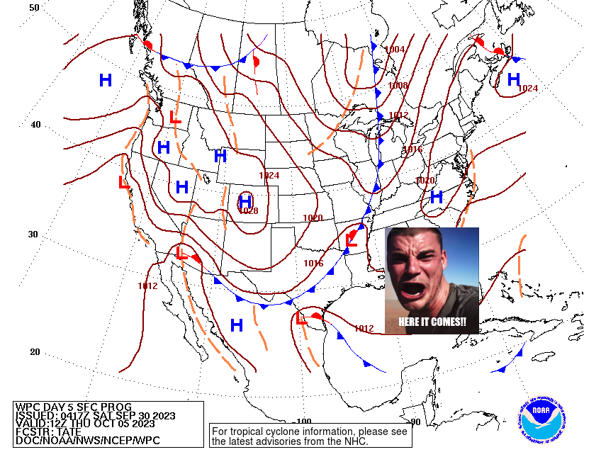
Here’s where things get a little tricky with the nature of the cold front. I am hoping for some rain to come of it and the Euro model looks more favorable for the front to bring in some rain before it arrives. The GFS, however, decided to shove all the rain down to Texas. While this might be something the GFS does in its medium-long range, we’ll have to wait a couple more days to see if the two models agree about rain associated with the cold front. While both are looking pretty different, they both agree on one thing: a very welcome cool-down. Next weekend looks to cool down around 5-10 degrees into the upper 70s and low 80s during the day and into the 50s at night.

While we wait for model guidance to agree on the rain, we do have something to look forward to next weekend as temperatures will begin to cool down and we start to feel more autumn-like. Have a good week!
[wpcode id=”41179″]
Regional Day-to-Day Forecast
Today – Sunny, with a high in the lower 90s. East northeast wind 5 to 10 mph.
Tonight – Mostly clear, with a low in the mid 60s. East northeast wind around 5 mph becoming calm.
Sunday – Sunny, with a high in the lower 90s. Light east northeast wind becoming east 5 to 10 mph in the morning. Winds could gust as high as 20 mph.
Sunday Night – Mostly clear, with a low in the low 60s. East northeast wind around 5 mph becoming calm.
Monday – Sunny, with a high near 90. Light east northeast wind becoming east 5 to 10 mph in the morning. Winds could gust as high as 20 mph.
Monday Night – Clear, with a low in the lower 60s. East northeast wind around 5 mph becoming calm.
Tuesday – Sunny, with a high in the upper 80s. Calm wind becoming east around 5 mph in the morning. Winds could gust as high as 20 mph.
Tuesday Night – Mostly clear, with a low in the low 60s. East southeast wind around 5 mph becoming calm.
Wednesday – Sunny, with a high in the upper 80s. Calm wind becoming east around 5 mph in the afternoon.
Wednesday Night – Partly cloudy, with a low in the low 60s.
Thursday – Mostly sunny, with a high in the upper 80s.
Thursday Night – A chance of showers overnight. Mostly cloudy, with a low in the mid 60s.
Friday – Mostly sunny, with a high in the low to mid 80s.
[wpcode id=”41149″]


