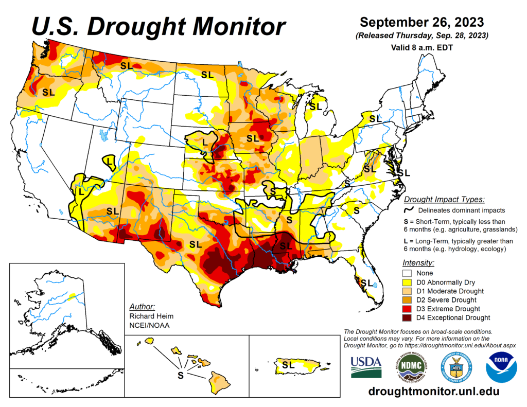
With a drought comes ecological and hydrological problems in the long term, but if you know anything about what happens out in the western US when there’s a drought, there’s bound to be wildfires. Seeing that most of the coastal Southern US is in an exceptional (Level 4) drought, we’ve already had a bout with some wildfires this summer. As stated by Nick, we haven’t had a drought this bad since the summer of 2000 and it looks like the relief will be a while as we’re in what’s typically one of our driest months of the year.

Our fire weather warning will remain until Wednesday since there’s no chance of rain in sight for the next few days. Not only that, but the wind will also be a big factor as we’ll get some wind gusts coming in during the day which can help spread the fire if it happens. Winds are pulling from the east associated with the midwestern ridge as we’re at the bottom end of it.
Our main relief from the fire weather concerns will be the rain chance near the weekend. It may not be a significant amount all things considered, but it may at least bring us out of the fire danger a bit. Looking at the CPC three month outlook, there looks to be good news for us after such a drought. We have a fair chance of above average precipitation going towards the end of the year. Although the early and middle parts of October may not be promising for precip, I wouldn’t doubt that November (rain) and December probably will.
For now, be very cautious about burning anything, don’t throw anything flammable on the ground as there’s fuel basically everywhere, and check your trailers before you hit the highway.
[wpcode id=”41179″]
Regional Day-to-Day Forecast
Tonight – Mostly clear, with a low around 62. East northeast wind around 5 mph becoming calm in the evening.
Monday – Sunny, with a high near 91. East wind 5 to 10 mph, with gusts as high as 20 mph.
Monday Night – Mostly clear, with a low around 60. East northeast wind around 5 mph becoming calm in the evening.
Tuesday – Sunny, with a high near 93. Light east northeast wind becoming east 5 to 10 mph in the morning.
Tuesday Night – Mostly clear, with a low around 61. East wind around 5 mph becoming calm in the evening.
Wednesday – Sunny, with a high near 93. East wind 5 to 10 mph.
Wednesday Night – Partly cloudy, with a low around 61. East wind 5 to 10 mph becoming light east southeast in the evening.
Thursday – Partly sunny, with a high near 92. Calm wind becoming east southeast around 5 mph in the morning.
Thursday Night – A 20 percent chance of showers. Mostly cloudy, with a low around 66. Northeast wind around 5 mph becoming calm in the evening.
Friday – A 20 percent chance of showers. Partly sunny, with a high near 86.
Friday Night – Mostly cloudy, with a low around 63.
Saturday – Partly sunny, with a high near 83.
Saturday Night – Mostly cloudy, with a low around 54.
Sunday – Mostly sunny, with a high near 79.
[wpcode id=”41149″]


