It still looks like Hurricane Ian is headed toward Florida, with no real, true threat to turn west and toward the central Gulf Coast.

Instead, we end up on the west side of Ian with some drier air mixing down with breezy conditions that will lead toward fire concerns.
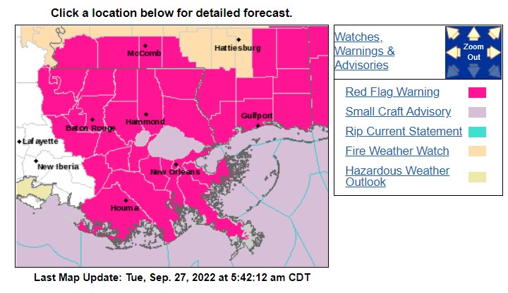
And the increased fire danger is evident across the entire area. So if you have any plans to do some outdoor burning, if you could put that off for a few days, it would be greatly appreciated by your friends and neighbors. And local fire departments.
Otherwise, it will be dry and breezy with plenty of sunshine.
DAY TO DAY FORECAST
Today
Sunny. Highs around 80. Northeast winds 10 to 15 mph.
Tonight
Clear. Lows in the upper 50s. Northeast winds around 10 mph.
Wednesday
Sunny. Highs around 80. Northeast winds 15 to 20 mph with gusts up to 30 mph.
Wednesday Night
Clear. Lows in the mid 50s. North winds 10 to 15 mph with gusts up to 25 mph.
Thursday
Sunny. Highs in the upper 70s. Northeast winds 10 to 15 mph with gusts up to 25 mph.
Thursday Night
Mostly clear. Lows in the upper 50s.FridaySunny. Highs around 80.
Friday Night
Mostly clear. A slight chance of showers in the evening. Lows around 60. Chance of rain 20 percent.
Saturday
Sunny with a 20 percent chance of showers. Highs in the lower 80s.
Saturday Night
Mostly clear. Lows in the upper 50s.
Sunday
Sunny. Highs in the lower 80s.
Sunday Night
Mostly clear. Lows in the lower 60s.
Monday
Sunny. Highs in the mid 80s.


