As Hurricane Ian moves toward the west coast of Florida, on the backside of the storm and nearer to a ridge of high pressure, all we have to worry about today is some gradient wind.

We talked about this yesterday and the day before and the day before that. When you have such a potent storm so close to a ridge of high pressure, it creates a pretty steep pressure gradient. And that gradient is what makes the wind blow.
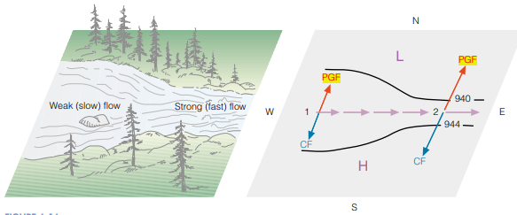
Why doesn’t is just blow straight from high pressure to low pressure? Well! It is because the Earth is rotating and we have to deal with something called Coriolis Force.


Without getting to into the weeds of Mass Balance Equations, as the earth rotates, it causes things that move from point A to point B to deflect to the right (northern hemisphere) or left (southern hemisphere). But the deflection has to be balanced by the pressure gradient force.
In the image above and on the left, the rotating Earth causes the air that is moving from point A to point B to deflect, Int he upper right image, we see the deflection is balanced by the gradient force. And the stronger the pressure gradient force, the stronger the Coriolis Force must be to balance it out.
And, as a rule of Physics, the stronger the Coriolis Force, the stronger the Wind. A good way to visualize this is by thinking about a creek in a forest.
Neat stuff! And this wind will also be mixed vertically in the atmosphere, too.
Going back to the water vapor image up top, the brown/orange color you see in there is very dry air due to subsidence on the backside of Ian – a very powerful hurricane. That subsidence (sinking air) is very dry. That dry air will mix down with the wind and leave the area with some very low humidity and higher wind speeds.
That is a combo to create ripe wildfire conditions. Which is why the NWS has issued Red Flag Warnings.

And they are butted up against Hurricane Warnings and Tropical Storm Warnings.
DAY TO DAY FORECAST
Today
Sunny. Highs in the upper 70s. North winds 15 to 20 mph with gusts up to 35 mph.
Tonight
Clear. Lows around 50. North winds 10 to 15 mph with gusts up to 25 mph.
Thursday
Sunny. Highs in the upper 70s. North winds 10 to 15 mph.
Thursday Night
Clear. Lows in the mid 50s. North winds 5 to 10 mph.
Friday
Sunny. Highs around 80. North winds 5 to 10 mph with gusts up to 20 mph.
Friday Night
Clear. Lows in the mid 50s.
Saturday
Sunny. Highs in the lower 80s.
Saturday Night
Clear. Lows in the upper 50s.
Sunday
Sunny. Highs in the mid 80s.
Sunday Night
Mostly clear. Lows in the upper 50s.
Monday
Sunny. Highs in the mid 80s.
Monday Night
Mostly clear. Lows around 60.
Tuesday
Sunny. Highs in the mid 80s.


Please pray for the residents of Florida and what they’re going through and ‘will’ go through. I just hope it will move on through and not slow down or stall.