Here is the latest from the National Hurricane Center:
5PM Advisory from the National Hurricane Center
Yup. Still not a Category 6. Because, well, that doesn’t exist. And won’t until (if they ever even do?) they revamp the scale.
As usual, here is an objective look – in plain English – at the storm and what you need to know about it. Because we are all on pins and needles after Harvey, the last thing we need is hyperbole. So here is a #nofilter look at everything Irma. Still borrowing a line from former United States Secretary of Defense Donald Rumsfeld, we are going to look at the known knowns. The known unknowns. And the unknown unknowns.
Known knowns
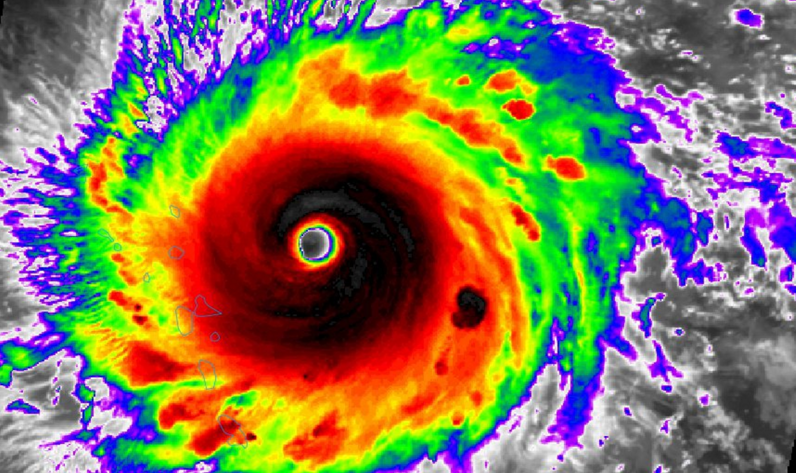
As stated above, Irma is a Category 5 storm with wind speeds at 185mph. The minimum centralized pressure is 926mb. Hurricane-force winds extend outward up to 60 miles from the center and tropical-storm-force winds extend outward up to 175 miles. This storm is much bigger than just a few days ago when the sustained hurricane-force wind was only 10 to 20 miles out from the center. The National Hurricane Center thinks this will continue as a Category 4 or stronger storm through Sunday.
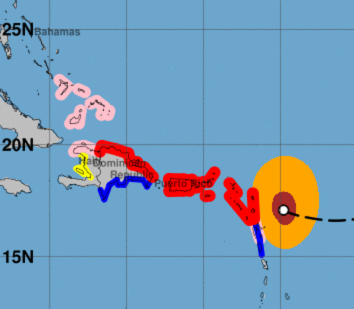
The National Hurricane Center is doing a great job with the forecast. And they have issued watches and warnings for islands in the Atlantic ahead of this storm.
From the NHC:
SUMMARY OF WATCHES AND WARNINGS IN EFFECT:
GOES 16 IRMA 9/5/17
A Hurricane Warning is in effect for…
* Antigua, Barbuda, Anguilla, Montserrat, St. Kitts, and Nevis
* Saba, St. Eustatius, and Sint Maarten
* Saint Martin and Saint Barthelemy
* British Virgin Islands
* U.S. Virgin Islands
* Puerto Rico, Vieques, and Culebra
* Dominican Republic from Cabo Engano to the northern border with HaitiA Hurricane Watch is in effect for…
* Guadeloupe
* Haiti from the northern border with the Dominican Republic to Le Mole St. Nicholas
* Turks and Caicos Islands
* Southeastern Bahamas
A Tropical Storm Warning is in effect for…
* Guadeloupe
* Dominica
* Dominican Republic from south of Cabo Engano westward to the southern border with Haiti
Watches & Warnings 9/5/17
A Tropical Storm Watch is in effect for…
* Haiti from south of Le Mole St. Nicholas to Port-Au-Prince
A Hurricane Warning means that hurricane conditions are expected somewhere within the warning area. A warning is typically issued 36 hours before the anticipated first occurrence of tropical-storm-force winds, conditions that make outside preparations difficult or dangerous. Preparations to protect life and property should be rushed to completion.
A Tropical Storm Warning means that tropical storm conditions are expected somewhere within the warning area.
A Tropical Storm Watch means that tropical storm conditions are possible within the watch area, generally within 48 hours.
Interests elsewhere in the Dominican Republic and Haiti, as well as Cuba, the central and northwestern Bahamas, and Florida should monitor the progress of Irma.
For storm information specific to your area in the United States, including possible inland watches and warnings, please monitor products issued by your local National Weather Service forecast office. For storm information specific to your area outside the United States, please monitor products issued by your national meteorological service.
Irma is forecast to begin to shift west-northwest overnight tonight and will move through the above-mentioned areas. It move over portions of the northern Leeward Islands tonight and early Wednesday, move near or over portions of the northern Virgin Islands Wednesday, and pass near or just north of Puerto Rico late Wednesday and Wednesday night. Areas that are closeest to the center of the storm and get hit by the eyewall will deal with estimated wind speeds of 185mph with gusts even higher.
That is comparable to an EF-4 tornado.
At the same time, storm surge of seven to 11 feet is anticipated in St. Croix on the Virgin Islands. Three to five feet of surge on the northern side of Puerto Rico. One to two feet on the southern side.
More from the NHC:
WIND: Hurricane conditions are expected within the hurricane warning area in the Leeward Islands tonight, with tropical storm conditions beginning within the next few hours. Hurricane conditions are expected to begin within the hurricane warning area in the British and U.S. Virgin Islands and Puerto Rico on Wednesday, with tropical storm conditions beginning tonight. Hurricane conditions are expected to begin within the hurricane warning area in the Dominican Republic early Thursday, with tropical storm conditions beginning Wednesday night.
Hurricane and tropical storm conditions are possible within the watch area in Haiti, the Turks and Caicos Islands, and the southeastern Bahamas by early Thursday.
RAINFALL: Irma is expected to produce the following rain accumulations through Thursday:
Northern Leeward Islands…8 to 12 inches, isolated 20 inches
Northeast Puerto Rico and the British and U.S. Virgin Islands except St. Croix…4 to 10 inches, isolated 15 inches S
outhwest Puerto Rico, the southern Leeward Islands, and St. Croix…2 to 4 inches
Irma is expected to produce the following rain accumulations Wednesday through Saturday:
Southeast Bahamas and Turks and Caicos…8 to 12 inches, isolated 20 inches
Northern Dominican Republic and northern Haiti…4 to 10 inches, isolated 15 inches
Southwest Haiti…1 to 4 inches
These rains could cause life-threatening flash floods and mudslides.
SURF: Swells generated by Irma will affect the northern Leeward Islands, Puerto Rico, the Virgin Islands, the southeastern Bahamas, the Turks and Caicos Islands, and the northern coast of the Dominican Republic during the next several days. These swells are likely to cause life-threatening surf and rip current conditions. Please consult products from your local weather office.
We know this is a dangerous storm and people in the Caribbean islands mentioned need to make plans to protect life and property ahead of this storm.
known unknowns
We know Florida is in the Cone of Uncertainty. But we aren’t certain exactly when the southern sections of Florida could feel the first effects from Irma. It could be as early as Saturday evening. Or as late as Sunday.
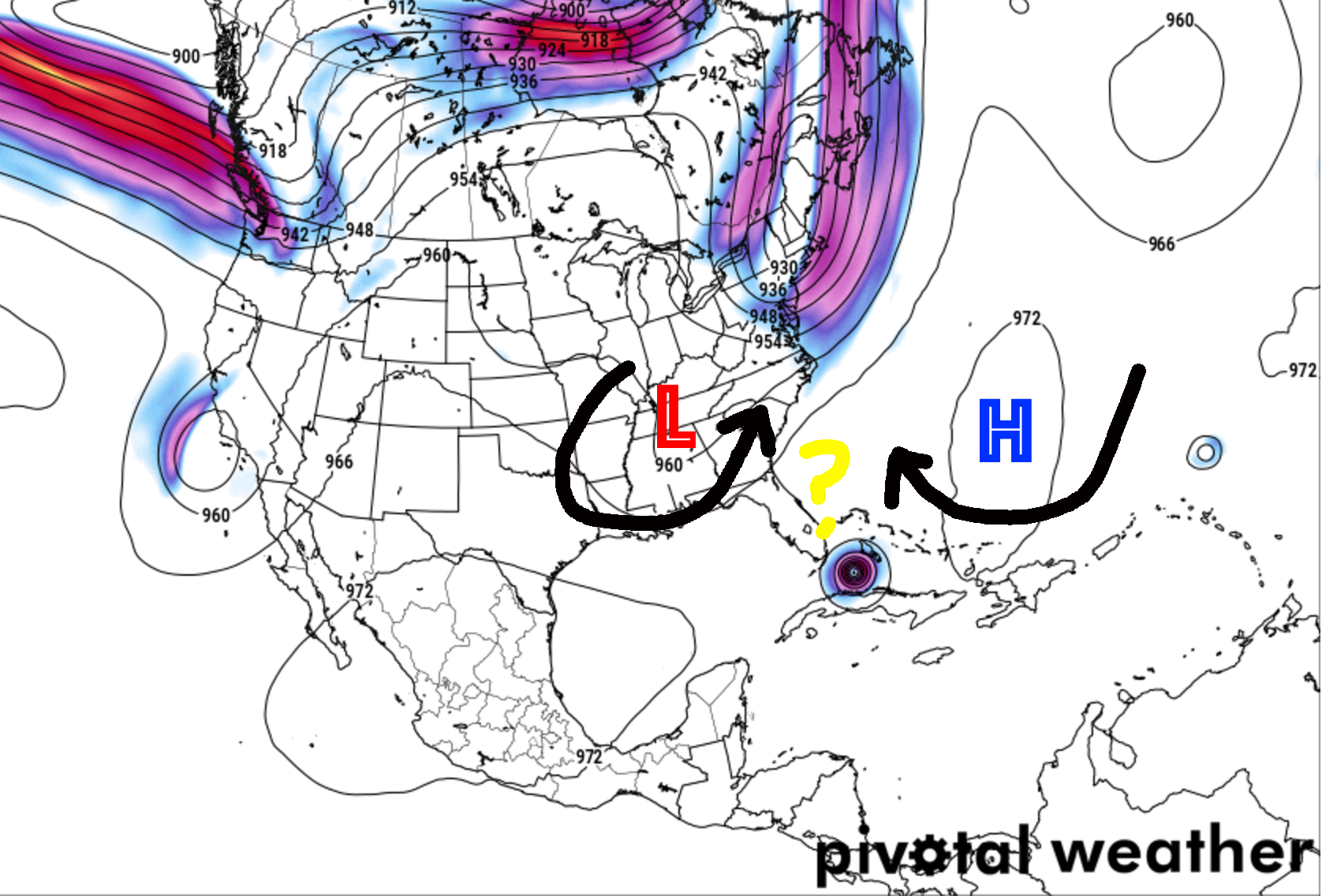
Irma’s forward speed may slow by later this week and it looks to turn north, too. This is still due to a handful of factors. We are still watching the same group of atmospheric paramters as before:
Atmospheric Interaction around Irma
1. Placement of ridge of High Pressure in the Atlantic
2. Strength of ridge of High Pressure in the Atlantic
3. Placement of the trough in the eastern 2/3 of the US later this week
4. Influence of Typhoon Sanvu on the jet stream
I’m adding a few things that may also change some things, too:
5. Placement of a lingering area of mid-level low pressure behind the trough mentioned above
6. Strength of that mid-level low
7. How close Irma gets to the islands of Puerto Rico, the Dominican Republic/Haiti, and Cuba
While we are stating to get a better idea of 1, 2, 3, and 4 due to the great work by the Hurricane Hunters, we still won’t have a good picture of what we are looking at until 48 to 72 hours out. As for 5 and 6, those are new wrinkles pointed out best by Philippe Papin.
The idea is that the relationship between the size and strength of the leftover mid-level low (numbers 5 and 6 above) and the area of High Pressure in the Atlantic (numbers 1 and 2 above) will dictate the exact track. But until we get closer, this is still a known unknown. And something we will all be watching closely.
And the above-mentioned relationship is then also contingent on the results of the number 7 above, too. If Irma tracks over every single island it will likely slow a bit more and weaken. The weaker it gets the more that may change the overall tendencies the storm has to follow the steering flow.
So, in a nut-shell, it is complicated. Models are still struggling to figure out (meteorologists call this “struggling to resolve”) what will happen given these different scenarios.
Florida #FLwx will have some sort of impact from #Irma. Comes down to that turn north and when. Models starting to favour eastern coast pic.twitter.com/HRMwockAI7
There are other differences between the American (GFS) and European (ECMWF) models. And then differences between those and the shorter-term models like the HWRF, HMON and TABS, TABM, TABD models. Some have struggled with outcomes, too. The good news? The Hurricane Hunters continue to take readings and collect data in and around Irma. That added data is helping those above-mentioned models create better forecasts. What those better forecasts look like are also something that we know that we don’t know.
I will say, though, it is probably encouraging for folks in Louisiana, Mississippi and Alabama to see very few lines on those models pointing toward them. For folks in Florida and Georgia, please keep a VERY close eye on this storm.
But given the nature of this storm and the atmosphere, it is important that you keep up with the forecast – wherever you live – as any hiccup in there could change the forecast drastically.
Unknown unknowns
Because it is the atmosphere, there are going to be things that are going to happen that we cannot foresee at this time. That is why it is important to be prepared for all possible outcomes. Live along the East Coast? Or along the Gulf Coast? Check your Hurricane Preparedness Kit. Don’t have one? Buy one! Here is a great link for that. There is no need to do much else yet. Check your plan, make sure your kit is ready to go and wait for the meteorological world to figure out what will happen with Irma.
Being prepared today means when it is time to act, you’ll be ready to go!
What should I do?
That depends on where you live. I’ve heard a lot of stories about people in Louisiana, Mississippi and Alabama going out to stores and buying up a ton of supplies and gas. That may not be necessary right now.
If you live in Florida – especially southern Florida – you need to start making plans to protect life and property. It may – very soon – be time to enact your Hurricane Plan, whatever that may be. Listen to local officials, seek information from local emergency managers, and pay attention to the forecast.
Author of the article:
Nick Lilja
Nick is former television meteorologist with stints in Amarillo and Hattiesburg. During his time in Hattiesburg, he was also an adjunct professor at the University of Southern Mississippi. He is a graduate of both Oregon State and Syracuse University that now calls Houston home. Now that he is retired from TV, he runs this site and its app in his spare time.