Good morning everyone, it’s finally Saturday! The major immediate story will once again be the dangerous heat. An Excessive Heat Warning is in effect for much of the area, with the exception of areas along the Southern Mississippi border with Louisiana (places like Woodville, McComb, and Columbia are just under a Heat Advisory). I’ll show an NWS graphic again, this shows the areas where the heat is expected to be the worst today.

Those areas in red and purple may see heat indices up to 115F this afternoon!
That kind of heat is very extreme, and very dangerous to do any kind of outdoor physical activity-if it can wait another day, it would be best to wait for tomorrow.
Usually, this area sees an excessive heat warning about once or twice per year, so today may very well be the hottest day of the year for many! Take precautions accordingly! It probably is going to be hotter than yesterday, as a benchmark.
So, what’s causing this? As we’ve been alluding to for the past month that we’ve been working here, the upper level ridge is still to blame. This is fairly typical in the summer, when the ridge parks over the Southern US and Atlantic Ocean, so it’s typical to have the same kind of weather over a long period of time.
This ridging is quite strong, though.

This is the 500 mb height and wind map for this morning from last night’s GFS. The core of the ridge is centered over the Rockies, but a ridge of high pressure (represented by the blue squiggly line) extends over our area-maintaining sinking, and warm air across the Deep South.
Let’s take a look at tomorrow morning and see how the pattern changes.

That ridge extension has shifted South, allowing for our area to get Northerly flow, or wind coming from the North. That’s great, because usually that means cooler and drier weather is coming!
Unfortunately, that isn’t exactly the case this time. We’re pretty thick into the summer, and the Midwest is extremely humid right now, so that Northerly wind won’t feel much better. The temperature will fall some, but not the kind of crashing cold fronts we see during the Fall.
This time in July, as the corn grows in Iowa, the plants tend to give off a lot of moisture. That actually does affect the weather, and will mean that our humidity will be just a little higher than it otherwise would.
The front is also decaying and stalling, so the dry air probably won’t even touch South Mississippi.

As we discussed, the real dry air is nowhere to be found. PWAT is a measure of moisture throughout the entire atmosphere, so even the “drier” values in Mississippi are misleading. It will be very humid at the surface, but PWAT is low because of dry air between 3-9 kilometers above the ground.

This is called a Skew-T diagram-there are lots of cool features, but we’re just looking at the temperature and humidity profile of the atmosphere. As you go up on the diagram, it’s like you go up in the air. The green line is our dewpoint, and the red line is the temperature.
The further away those two lines are, the lower the humidity is. You can see that most of the atmosphere is very dry, but unfortunately, the part of the atmosphere that we live in and breathe in, is very humid.
That’s why, although PWAT maps are very helpful, we do have to be careful when using them.
Underneath the frontal boundary, there is extreme PWAT, indicating lots of moisture throughout the entire atmosphere. Since the moisture is going to be placed on a stalled out front, heavy rain and thunderstorms are likely.
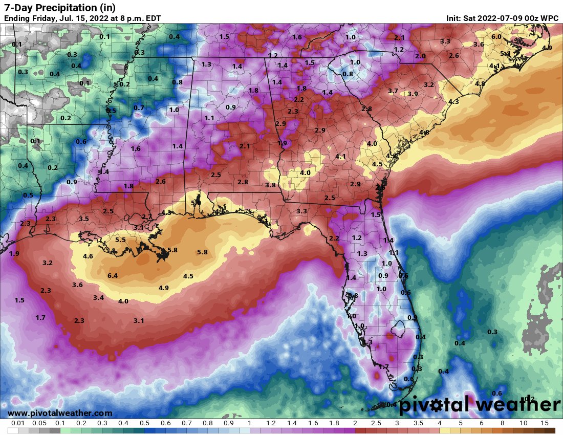
As always, I have the WPC 7-day rainfall forecast posted above. This forecast is higher than the last one I shared, as a good portion of the area is in the 1-2” range over the next week. Higher moisture will be located closer to the coast, so more rainfall is likely further to the South.
Current indications that a large part of that rain is going to come down tonight and tomorrow, and while it isn’t a guaranteed washout, some heavy rains are possible during those times. We might get a temporary break Monday, but the rains are coming back to linger through the next week.
Widespread severe weather isn’t anticipated at this time, but some of the storms tomorrow could feature some strong wind gusts. Dry air aloft, which is what we looked at earlier, enhances a parameter we call DCAPE. DCAPE is a measure of the downdraft potential in thunderstorms, or how likely a storm is to produce damaging winds.
Because of the drier air way above our heads, this parameter is moderately high, so if there is a Severe Thunderstorm Warning issued for your location, it would be best to head inside and stay away from windows.
But, once again, the SPC doesn’t have a risk outlined-this is just a very slight threat I picked up on. Just something to remember, that’s all!
Day to Day Forecast
Today
Mostly sunny, with a 30-percent chance of scattered thunderstorms during the day, increasing to 70-percent overnight. Highs in the mid-90s. The heat index may reach 115F.
Tomorrow
Mostly cloudy, with a 60-percent chance of ran and thunderstorms. Highs in the upper-80s.
Monday
Partly cloudy, with a 30-percent chance of scattered afternoon thunderstorms. Highs in the low-90s. The heat index may reach 100F.
Tuesday
Partly sunny, with a 50-percent chance of afternoon thunderstorms. Highs in the upper-80s.
Wednesday
Partly cloudy, with a 70-percent chance of afternoon thunderstorms. Highs in the mid-80s.
Thursday
Mostly cloudy, with a 70-percent chance of rain and thunderstorms. Highs in the mid-80s.
Friday
Mostly cloudy, with a 40-percent chance of rain and thunderstorms. Highs in the upper-80s.


