The combination of a mid-latitude cyclone and the remnants of Invest 91L will lead to some very heavy rain for the Gulf Coast. Despite the recent dry conditions across south Mississippi, given the potential for heavy rain in the coming days, flooding is becoming a concern for the region.
The Weather Prediction Center has already issued a Moderate Risk for excessive rainfall / flash flooding for sections of the Gulf Coast region (mainly Texas and Louisiana) for Wednesday and Thursday. There is a good chance that the Moderate Risk is extended to the northeast to cover most of southern Mississippi – and perhaps Alabama – on Friday.

What we know now
Model guidance continues increase the estimated rainfall totals across parts of southern Mississippi during the day on Thursday, Friday and into Saturday. Given the latest available data, and other model trends, rainfall totals of 1″ to 3″ will be likely across southern Mississippi between Thursday and Saturday. Some places could receive up to 6″ of rain, depending on how storms align and if they train over certain areas.
Important to note: Widespread March 2016 type flooding isn’t anticipated. And given how dry it has been for the area, 1″ to 3″ over three days isn’t likely going to cause flooding, either. But any additional rainfall, or receiving that much rain in one day rather than three, may cause localized flooding.
But again, given the available data, widespread flooding isn’t a concern at this time.
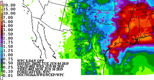
Then, Sunday and Monday, an additional 1″ to 2″ of rain is possible.
When it starts
The area will receive some rain during the day on Wednesday as a few thunderstorms drift through. A bulk of the rain will show up on Thursday and Friday as what is left of Invest 91L gets dragged across Louisiana, Mississippi and Arkansas and into a mid-latitude cyclone. Lingering showers and storms on Saturday will give way to ‘summertime storms’ on Sunday and Monday.
What we are still trying to figure out
We are still trying to nail down exactly where the heaviest rain will fall. That is going to depend on a lot of different things that can’t be forecast yet (or at all, in some cases) because there isn’t high-enough-resolution data to look at yet. That comes into play within 36 hours of an event (in this case, likely late Wednesday night).

The other piece we are still trying to nail down is just how long the area of low pressure decides to stick around. The slower it moves through th area, the more rain the region will receive. The faster it moves, the less rain the area will receive.
Bottom Line
It is going to rain quite a bit on Thursday and Friday. While your specific area may not get the highest totals, thunderstorms will be able to drop a lot of water in a short period of time.
If you have to run errands or be out and about on Thursday and Friday, make sure your windshield wipers work well, you have an umbrella, and if you have any outdoor plans, make sure you have a backup plan that includes somewhere you can duck inside.


