The National Hurricane Center says there is a high chance for development int eh coming days for Invest 92L.
1. A broad area of low pressure is located over the central Caribbean Sea, a little less than 100 miles south-southeast of eastern Jamaica. Recent satellite wind data and visible satellite imagery indicate that the circulation is gradually becoming better defined, however, the associated shower and thunderstorm activity has
changed little in organization since this morning. Environmental conditions are expected to be conducive for additional development, and a tropical depression is likely to form within the next day or so, while the system moves over the central and northwestern Caribbean Sea. The disturbance is forecast to move near Jamaica
through Monday, and then pass near the Cayman Islands early Tuesday and approach western Cuba by late Tuesday, and interests in those areas should closely monitor the progress of this system.
Courtesy: nhc.noaa.gov
The low is forecast to move into the southern or southeastern Gulf of Mexico Tuesday night or Wednesday. Regardless of development, locally heavy rainfall and gusty winds will be possible across portions of Hispaniola, Jamaica, the Cayman Islands, and Cuba during the next few days. This rainfall could lead to
life-threatening flash floods and mudslides.
* Formation chance through 48 hours…high…80 percent.
* Formation chance through 5 days…high…80 percent.
Model Data
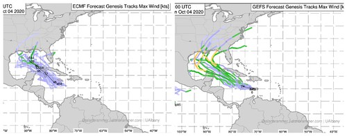
The model data is a bit unsettling today. I’m not ready to start “sounding the alarm” or go into DEF:CON mode for the northern Gulf Coast, but I am ready to go to “Hey guys… let’s watch this thing a bit closer” mode.
Courtesy: Alan Brammer at UAlbany
Both the GEFS and the ECMWF ensembles show a pretty good chance that this ends up into the Gulf of Mexico as – at least – a Tropical Storm.
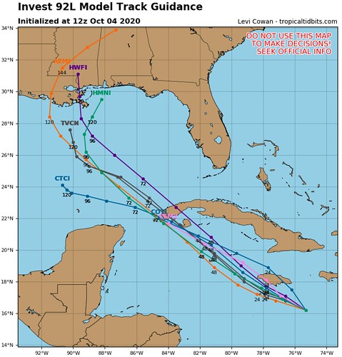
On top of that, other guidance also moves Invest 92L toward the Gulf of Mexico.
Courtesy: Tropical Tidbits
So, as of now, most – if not all – of the model guidance takes this thing into the Gulf during the next four days.
What will it look like when it gets there? Well. That is still “to be determined” but the model guidance we have access to is currently rather aggressive with how much it intensifies.
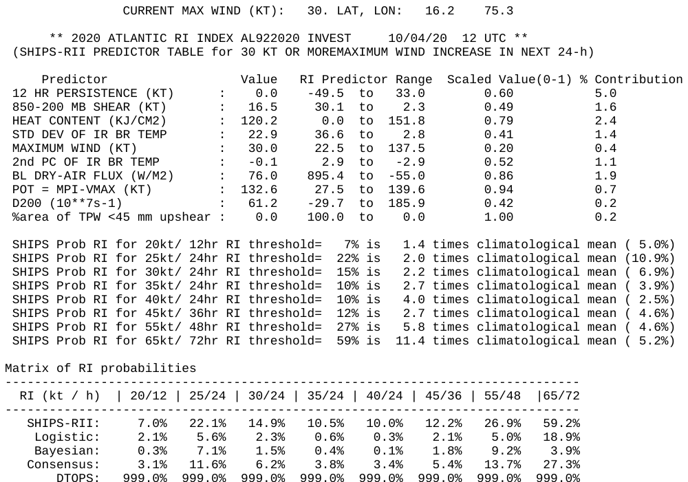
The SHIPS model shows a 59-percent chance that it gains 65kts of wind speed during the next 72 hours.
Courtesy: nhc.noaa.gov
That is more than 11-times higher than the climatological average.
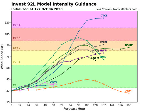
Other guidance is on-board with a reasonable amount of intensification, too.
Courtesy: Tropical Tidbits
While I don’t like to look out beyond 72 hours, you can see that between the available data, it shows somewhere between a weak Tropical Storm and a Category 2 Hurricane. So there is still quite a bit of spread.
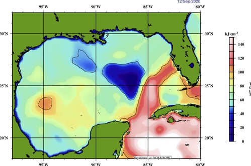
Water Temperatures
The good news is that the Gulf of Mexico is not the Hot Tub it was just a month ago.
Courtesy: aoml.noaa.gov
That is a look at the Tropical Cyclone Heat Potential, 25C Isotherm, and the Sea Height Anomaly for the Gulf of Mexico. Those numbers are quite a bit lower today than the last time a tropical cyclone threatened the northern Gulf Coast.
Here is the Tropical Cyclone Heat Potential map for the Gulf when Hurricane Sally passed through.
Courtesy: aoml.noaa.gov
That said, here is that same map in the days leading up to Hurricane Michael.
Courtesy: aoml.noaa.gov
So while we are in a better position as far as water temperatures go compared to a month ago. We are still on-pace with the last time a Major Hurricane formed in the Gulf. So, we can’t simply look at the water temperatures and go, “well, no biggie, the temps are cooler.”
Bottom Line
Please keep up with the forecast in the coming days. Invest 92L may develop into a Tropical Storm during the next 24 to 48 hours. And it would get into the Gulf by later this week.
What happens after that? Still uncertain.
But now is a good time to review your Hurricane Preparedness Kit. Make sure you have the supplies to last without power or water for three to seven days. Make sure you’ve got food, water and medical supplies (if needed).
And please – PLEASE! – keep checking back on the forecast as we move through this next week.
Author of the article:
Nick Lilja
Nick is former television meteorologist with stints in Amarillo and Hattiesburg. During his time in Hattiesburg, he was also an adjunct professor at the University of Southern Mississippi. He is a graduate of both Oregon State and Syracuse University that now calls Houston home. Now that he is retired from TV, he runs this site and its app in his spare time.