Anyone else exhausted from Hurricane Season? I know I am. If this could be my last blog post for a hurricanes during 2020, I’d be ecstatic. This is getting old.
But hey, here we are. Tropical Storm Delta. Currently in the northwest Caribbean and moving – slowly – toward the Gulf. Currently, the expectation is for the storm to strengthen into the Hurricane and make landfall along the northern Gulf Coast Friday.
So let’s dive into the details.
Right Now
SUMMARY OF 1100 AM EDT
LOCATION…16.4N 78.6W
ABOUT 135 MI…215 KM S OF NEGRIL JAMAICA
ABOUT 265 MI…425 KM SE OF GRAND CAYMAN
MAXIMUM SUSTAINED WINDS…45 MPH…75 KM/H
PRESENT MOVEMENT…W OR 280 DEGREES AT 7 MPH…11 KM/H
MINIMUM CENTRAL PRESSURE…1002 MB…29.59 INCHES
As Gamma continues to get pulled apart – the convection lifting NE while the center sags SW – that will set the stage for Delta to slip in behind it and move into the southern Gulf during the day Tuesday and into Wednesday.
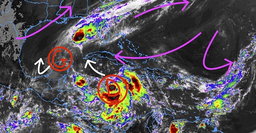
Right now, you can see that Delta is in a position getting pushed to the west by the prevailing mid-level flow. This flow starts to ease up near the straits between the Yucatan and Cuba.
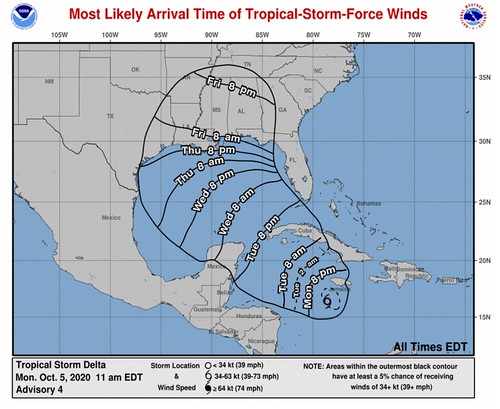
From the National Hurricane Center
FORECAST GRAPHIC
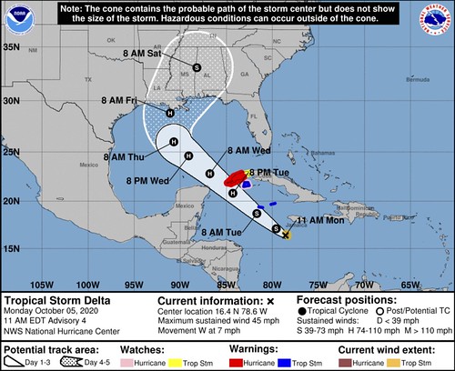
FORECAST POSITIONS AND MAX WINDS
INIT 05/1500Z 16.4N 78.6W 40 KT 45 MPH
12H 06/0000Z 17.1N 79.6W 50 KT 60 MPH
24H 06/1200Z 18.7N 81.7W 60 KT 70 MPH
36H 07/0000Z 20.8N 84.3W 75 KT 85 MPH
48H 07/1200Z 22.8N 86.8W 85 KT 100 MPH
60H 08/0000Z 24.6N 89.1W 90 KT 105 MPH
72H 08/1200Z 26.0N 90.7W 90 KT 105 MPH
96H 09/1200Z 28.8N 91.1W 85 KT 100 MPH
120H 10/1200Z 33.1N 88.2W 40 KT 45 MPH…INLAND
OUTLOOK
At 1100 AM EDT (1500 UTC), the center of Tropical Storm Delta was located near latitude 16.4 North, longitude 78.6 West. Delta is moving toward the west near 7 mph (11 km/h), and a turn toward the west-northwest is forecast later today. A faster northwestward motion is expected on Tuesday and Wednesday. On the forecast track, the center of Delta is expected to move away from Jamaica later today, move near or over the Cayman Islands early Tuesday, and approach western Cuba Tuesday afternoon or evening. Delta is forecast to move into the southeastern Gulf of Mexico Tuesday night, and be over the south-central Gulf of Mexico on Wednesday.
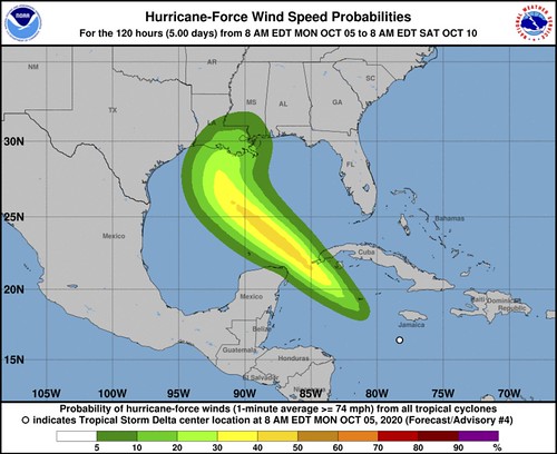
Maximum sustained winds have increased to near 45 mph (75 km/h) with higher gusts. Additional strengthening is expected during the next few days, and Delta is expected to become a hurricane on Tuesday before it nears western Cuba.
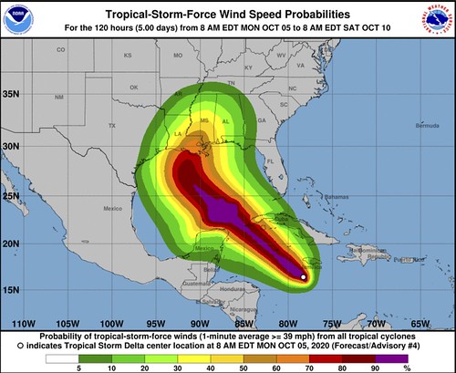
Tropical-storm-force winds extend outward up to 45 miles (75 km)from the center.
The estimated minimum central pressure is 1002 mb (29.59 inches).
TECHNICAL DISCUSSION
The convective structure of Delta has continued to improve this morning. Earlier microwave data and early-light visible satellite imagery showed that the center of the tropical cyclone re-formed farther south within the area of deep convection. Since that time, banding has continued to increase around the southern and eastern portion of the circulation, and a small CDO-like feature has formed. The intensity has been set at 40 kt, which is a blend of the subjective Dvorak estimate from TAFB and objective satellite intensity estimates from UW/CIMSS. A NOAA Hurricane Hunter aircraft is scheduled to investigate the tropical storm this afternoon, which should provide a better assessment of the cyclone’s intensity, structure, and wind field.
With the earlier center re-formation, the initial motion estimate is a somewhat uncertain 280/6 kt. Delta is expected to resume a west-northwestward motion later today. A northwestward heading around the southwestern portion of a deep-layer ridge should begin tonight or Tuesday, and that general motion with some increase in forward speed is expected to continue through 60-72 hours. After that time, a broad mid- to upper-level trough is forecast to develop over the south-central United States, which should weaken the western portion of the ridge and cause Delta to turn northward toward the northern Gulf Coast. After day 4, Delta should begin to accelerate north-northeastward or northeastward ahead of the aforementioned trough. The new NHC track forecast has been adjusted to the south and west of the previous advisory during the first couple of days, primarily due to the recent center re-formation and more southward initial position. After that time, the NHC track is not much different than the previous forecast and lies near the center of the tightly clustered dynamical model envelope.
Delta is forecast to traverse very warm waters over the northwestern Caribbean Sea and be in a very low vertical wind shear environment during the next couple of days. These conditions should allow for significant strengthening during that time, and the NHC intensity forecast is at or above the various intensity aids. It is somewhat surprising that the intensity aids were generally a little lower this cycle, but the expected low shear and SHIPS rapid intensification index support the higher than climatological rate of intensification. After 72 hours, increasing southwesterly shear and the cooler shelf waters over the northern Gulf are likely to induce some weakening later in the period. The updated NHC intensity forecast calls for a faster rate of intensification over the next 48-60 hours, but is similar to the previous advisory thereafter.
KEY MESSAGES
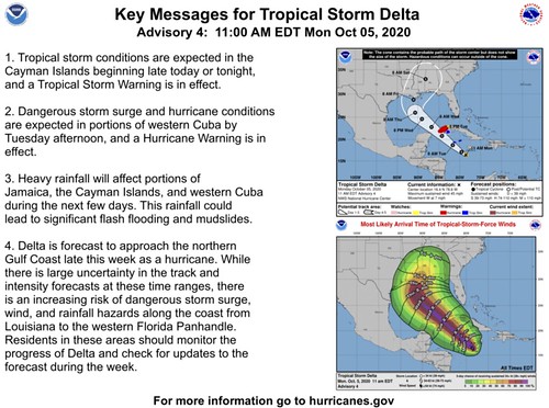
1. Tropical storm conditions are expected in the Cayman Islands beginning late today or tonight, and a Tropical Storm Warning is in effect.
2. Dangerous storm surge and hurricane conditions are expected in portions of western Cuba by Tuesday afternoon, and a Hurricane Warning is in effect.
3. Heavy rainfall will affect portions of Jamaica, the Cayman Islands, and western Cuba during the next few days. This rainfall could lead to significant flash flooding and mudslides.
4. Delta is forecast to approach the northern Gulf Coast late this week as a hurricane. While there is large uncertainty in the track and intensity forecasts at these time ranges, there is an increasing risk of dangerous storm surge, wind, and rainfall hazards along the coast from Louisiana to the western Florida Panhandle. Residents in these areas should monitor the progress of Delta and check for updates to the forecast during the week.
Model Data
A lot like with Laura, Hannah and a few of the other storms this hurricane season, model data for Delta has been a bit more consistent. So far. I’m not ready to jump on-board and believe everything I see, but it is nice to see the data not jump around like crazy like it did with Marco, Sally and Beta.
Starting with the GFS and Euro ensemble data, you can see the clusters between the members are packed tighter for this storm than any other recent storm.
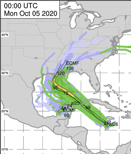

It is interesting to note that the storm data cones for both Gamma and Delta on the GFS ensembles move across the northern Gulf Coast.
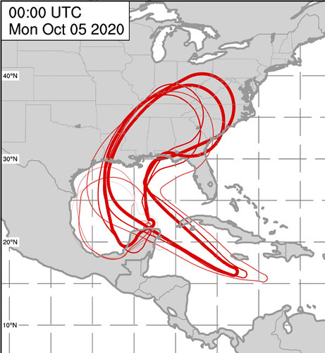
It is important to point out that if this scenario were to materialize, Gamma would likely be a very weak system. Perhaps not even a Tropical Storm.
Back to Delta, though. The other track guidance is in agreement with the ensembles, too.
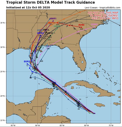
In fact, through the next 72 hours almost every single piece of model data I can find that will offer a forecast track for Delta put it into roughly the same area of the central Gulf of Mexico by Wednesday night.
Beyond there, there is some spread, but that spread is pretty confined to somewhere between New Iberia, Louisiana and Pensacola, Florida. In fact, the HMRF, which is a model that has performed reasonably well this summer, puts landfall somewhere along the Louisiana coast next Morgan City, Louisiana. That is close to the center of the current Forecast Cone from the National Hurricane Center.
Model guidance for how strong Delta will be when it gets here is a bit more “up in the air” for a few different reasons. First, though, here is a look at the data:
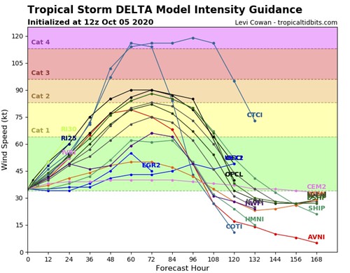
Now, as I say all the time, I don’t ever like looking at intensity data more than 72 hours out because the models don’t tend to handle that every well.
In this case, that still holds true, despite the track model forecasts looking like they are handling things well.
The current intensity data shows that Delta will be somewhere between a Tropical Storm and a Category 2 Hurricane in 72 hours. That said, the SHIPS model data shows the percent-chance for Rapid Intensification from a Tropical Storm into Category 2 – perhaps even Category 3 – Hurricane is sitting around 60-percent right now.
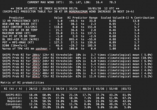
That is really high. Nearly 12-times higher than the climatological mean. And worth watching during the next 72 hours.
Water Temperatures
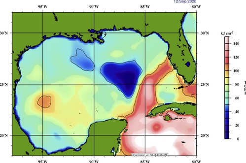
The good news is that the Gulf of Mexico is not the Hot Tub it was just a month ago.

That is a look at the Tropical Cyclone Heat Potential, 25C Isotherm, and the Sea Height Anomaly for the Gulf of Mexico. Those numbers are quite a bit lower today than the last time a tropical cyclone threatened the northern Gulf Coast.
Here is the Tropical Cyclone Heat Potential map for the Gulf when Hurricane Sally passed through.
That said, here is that same map in the days leading up to Hurricane Michael.

So while we are in a better position as far as water temperatures go compared to a month ago. We are still on-pace with the last time a Major Hurricane formed in the Gulf. So, we can’t simply look at the water temperatures and go, “well, no biggie, the temps are cooler.”
Bottom Line
Please keep up with the forecast in the coming days. Tropical Storm Delta continues to move toward the Gulf. The forecast is for Delta to make landfall as a Hurricane – perhaps even a Category 2 Hurricane. And the Weather Service always says”preapre for one category higher than the projected landfall.”
So now is a good time to review your Hurricane Preparedness Kit. Make sure you have the supplies to last without power or water for three to seven days. Make sure you’ve got food, water and medical supplies (if needed).
And please – PLEASE! – keep checking back on the forecast as we move through this next week.
Given the cooler water temperatures near the coastline, there is a chance that even if this storm blows up in the center of the Gulf, it may weaken as it moves closer to land.
But that is still uncertain.
So please take the time to prepare now. And prepare for the worst. Hope for the best.


