Invest98L shows better chance for development during next few days
Author: Nick Lilja
|| Published: 7/5/2020 at 2:32pm
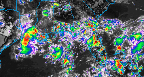
GOES-16 Infrared satellite imagery // Courtesy: College of DuPage Meteorology
The National Hurricane Center continues to monitor a cluster of storms in/near the Gulf of Mexico for development in the coming days as the center of the cluster drifts northeast and into the Atlantic. This area has been classified Invest 98L.
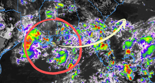
GOES-16 Infrared satellite imagery // Courtesy: College of DuPage Meteorology
The atmosphere will be much more conducive for development as this cluster drifts across Florida. For now, it is still getting better organized.
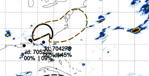
From the NHC
Tropical Weather Outlook
NWS National Hurricane Center Miami FL
200 PM EDT Sun Jul 5 2020
For the North Atlantic…Caribbean Sea and the Gulf of Mexico:
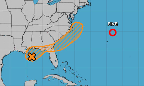
The National Hurricane Center is issuing advisories on Tropical Depression Five, located a few hundred miles northeast of Bermuda.
1. Recent satellite and radar observations indicate that a small low pressure system has formed within a broader area of low pressure near the northern Gulf Coast. The low is producing a few showers near its center, and some slight development is possible before it moves inland early Monday. The broader low pressure system is forecast to move northeastward and could emerge offshore of the Carolinas later this week, where environmental conditions are expected to be more conducive for development.
GOES-16 Infrared satellite imagery // Courtesy: College of DuPage Meteorology
* Formation chance through 48 hours…low…20 percent.
* Formation chance through 5 days…medium…40 percent.
Model Data
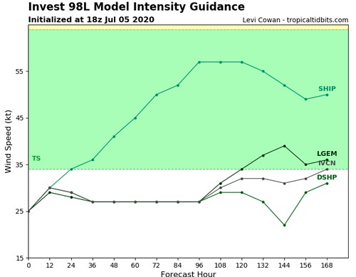
It is interesting to look at the model data for Invest 98L. Since it is pretty disorganized the model data can’t do a very good job at figuring out what will happen with it. And that is pretty typical.
Courtesy: Tropical Tidbits
Of the intensity model data that is available, you can see that only one model does anything with it. The GFS Ensembles show a chance for development as it drifts into the Atlantic, but even the GEFS shows two areas of possible development within the same cluster.
Courtesy: Alan Brammer
You may be thinking, “TWO?!” but don’t worry. The only reason it “sees” two is because it can’t find one. It is a bit like when you have a “two quarterback system” on a football team. It isn’t because you have “two really good quarterbacks” it is more because you couldn’t find “one” to be the full time leader.
Tropical Depression Five
Tropical Depression Five is still floating around out there, too. This one doesn’t look to be like much of a threat to the mainland United States.
From the NHC:
Tropical Depression Five Discussion Number 5
NWS National Hurricane Center Miami FL AL052020
1100 AM AST Sun Jul 05 2020
The depression is accelerating northeastward, away from Bermuda. It continues to produce deep convection primarily to the south of its center with little change in organization since yesterday. The most recent TAFB Dvorak classification supports maintaining the intensity at 30 kt. Scatterometer data that will likely arrive after the issuance of this advisory may provide more information about the current surface wind structure of the cyclone.
No substantial changes were made to the NHC forecast. The cyclone will continue to accelerate northeastward or east-northeastward during the next day or two. It is possible that the depression could open into a trough at some point today as its forward speed increases, but most of the dynamical guidance indicates it will persist long enough to undergo extratropical transition on Monday. Minimal strengthening is possible today as the forward speed of the depression increases and it begins to get some positive baroclinic support. In fact, nearly all of the global models indicate that the system will produce tropical-storm-force winds around the time it becomes fully extratropical, and this is reflected in the official forecast.
Neither of these systems pose an immanent threat for catastrophic damage for the Gulf Coast. That said, Invest 98L will continue to soak parts of Louisiana, Mississippi, Alabama, Florida and Georgia with summertime rain until it moves east.
Author of the article:
Nick Lilja
Nick is former television meteorologist with stints in Amarillo and Hattiesburg. During his time in Hattiesburg, he was also an adjunct professor at the University of Southern Mississippi. He is a graduate of both Oregon State and Syracuse University that now calls Houston home. Now that he is retired from TV, he runs this site and its app in his spare time.