We will hold on to a shot for rain, here and there, over the next few days – but I wouldn’t bank on seeing a ton of precip. Model guidance suggests that the “biggest winners” from rain will only pick up about 0.5″ to 1.0″ of rain.
You can check the AI-assisted weather maps below for more details hour-by-hour for your area, but keep in mind that the rainfall is measure in millimeters on these maps. So if you see big numbers, you have to divide the number by 25 to get the reading in inches.
[wpcode id=”41179″]If you get stuck underneath one of the stronger storms today and it doesn’t move quite as quickly as expected, you could pick up 1.5″ but that isn’t a very likely scenario.
The most likely scenario is for things during the next few days to look a bit like they did yesterday: very spotty storms with some rain here and there, but not enough meaningful rain to help the drought.
Aside from teh spotty storms, the other thing on our radar is a new are to monitor in the Gulf.
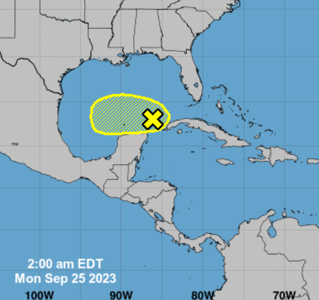
From the NHC:
Disorganized showers and thunderstorms continue over the southeastern Gulf of Mexico in association with a surface trough of low pressure and an upper-level trough. Further development, if any, is expected to be slow to occur over the next few days while the system moves slowly westward. By the middle of the week, upper-level winds are forecast to become less conducive for additional development.
–Formation chance through 48 hours…low…10 percent.
–Formation chance through 7 days…low…10 percent.
Operational model guidance has been rather aggressive some days with developing this area into something, while other days it shows almost nothing. But you guys know the story, by now, just as well as I do — until this thing has a center, the models won’t handle development very well at all.
So we will continue to monitor things.
[wpcode id=”41149″]
REGIONAL DAY TO DAY FORECAST
Monday: Mostly sunny with some storms possible. Highs in the lower 90s. southwest wind around 5 mph. Chance of rain 40 percent.
Monday Night: Mostly cloudy. Lows around 70. Southeast winds around 5 mph in the evening, becoming light and variable.
Tuesday: Partly sunny with some storms possible. Highs around 90. East winds 5 to 10 mph. Chance of rain 50 percent.
Tuesday Night: Mostly cloudy with storms ending early. Lows around 70. East winds 5 to 10 mph in the evening, becoming light and variable.
Wednesday: Mostly cloudy with some isolated storms possible. Highs in the mid 80s. Chance of rain 20 percent.
Wednesday Night: Mostly cloudy. Lows in the upper 60s.
Thursday: Partly sunny. Highs in the mid 80s.
Thursday Night: Mostly cloudy. Lows in the upper 60s.
Friday: Mostly sunny.. Highs in the upper 80s.
Friday Night: Mostly clear. Lows in the mid 60s.
Saturday: Sunny. Highs around 90.
Saturday Night: Mostly clear. Lows in the mid 60s.
Sunday: Sunny. Highs around 90.


