Checking in on the latest from the Climate Prediction Center, a La Nina Watch is now in effect for the Pacific Ocean. And El Nino Advisory remains in effect.
ENSO Alert System Status: El Niño Advisory / La Niña Watch
A El Nino Advisory is still in effect because El Nino Conditions are being observed currently. This makes sense as we are coming out of a brief – and potent – El Nino. The La Nina Watch is in effect because there is an anticipation of La Nina conditions to emerge through the end of Spring and into Summer this year.
WHAT IS A LA NINA?
Right. It actually does have some hard numbers to it, it isn’t just some abstract ‘cooler’ or ‘warmer’ measurement. La Nina occurs when the sea-surface temperatures are lower than 0.5 degree below average. The atmosphere – globally! – responds to this change. The cooler water temperatures moves the jet stream to different areas and increases the chances that different weather to happen in different areas.
The textbook definition of La Nina from NOAA sounds like this:
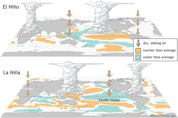
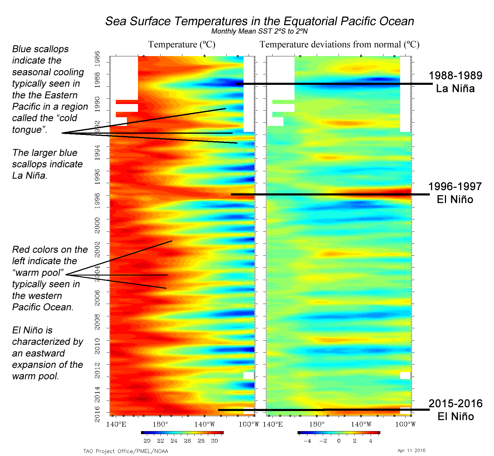
La Niña is characterized by unusually cold ocean temperatures in the Equatorial Pacific, compared to El Niño, which is characterized by unusually warm ocean temperatures in the Equatorial Pacific. The graphic below shows the sea surface temperature in the equatorial Pacific (20ºN-20ºS, 100ºE-60ºW) from Indonesia on the left to central America on the right.
Historically, the ocean goes back and forth between El Nino and La Nina. That back-and-forth action is called ENSO by scientists. It stands for El Nino Southern Oscillation. Sometimes we are in an El Nino (more warmer water) and other times we are in a La Nina (more cooler water).
The reason one develops instead of the other is – quite – complicated so hang on tight, we are about to get nerdy…
ENSO is the result of the interaction between the surface layers of the ocean and the immediate atmosphere above it in the tropical Pacific. The internal dynamics of that relationship (the coupled ocean-atmosphere system) involving unstable air-sea interaction and planetary-scale oceanic waves determines which one, El Nino or La Nina, happen. Because the interaction is locally based, but results in global changes, forecasting the development or termination of either El Nino or La Nina is both very difficult and important.
The reason ENSO changes what the atmosphere does, and not the other way around is because this change in water temperature is not seasonally dependent. It isn’t like lake or river temperatures where it is cooler in the winter and warmer in the summer.
THE FORECAST
The forecast is that La Nina will persist through this Spring and start to wane into the Summer. That will give way to more neutral conditions and then we will shift into La Nina this Summer and intot he Autumn.
From NOAA:
During January 2024, above-average sea surface temperatures (SST) continued across most of the equatorial Pacific Ocean [Fig. 1]. SST anomalies weakened slightly in the eastern and east-central Pacific, as indicated by the weekly Niño index values [Fig. 2]. However, changes were more pronounced below the surface of the equatorial Pacific Ocean, with area-averaged subsurface temperature anomalies returning to near zero [Fig. 3]. Although above-average temperatures persisted in the upper 100 meters of the equatorial Pacific, below-average temperatures were widespread at greater depths [Fig. 4]. Atmospheric anomalies across the tropical Pacific also weakened during January. Low-level winds were near average over the equatorial Pacific, while upper-level wind anomalies were easterly over the east-central Pacific. Convection remained slightly enhanced near the Date Line and was close to average around Indonesia [Fig. 5]. Collectively, the coupled ocean-atmosphere system reflected a weakening El Niño.
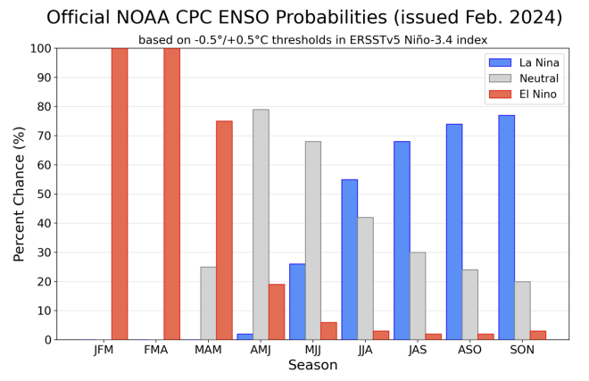
The most recent IRI plume indicates a transition to ENSO-neutral during spring 2024, with La Niña potentially developing during summer 2024 [Fig. 6]. Even though forecasts made through the spring season tend to be less reliable, there is a historical tendency for La Niña to follow strong El Niño events. The forecast team is in agreement with the latest model guidance, with some uncertainty around the timing of transitions to ENSO-neutral and, following that, La Niña. Even as the current El Niño weakens, impacts on the United States could persist through April 2024 (see CPC seasonal outlooks for probabilities of temperature and precipitation). In summary, a transition from El Niño to ENSO-neutral is likely by April-June 2024 (79% chance), with increasing odds of La Niña developing in June-August 2024 (55% chance; [Fig. 7]).
This discussion is a consolidated effort of the National Oceanic and Atmospheric Administration (NOAA), NOAA’s National Weather Service, and their funded institutions. Oceanic and atmospheric conditions are updated weekly on the Climate Prediction Center web site (El Niño/La Niña Current Conditions and Expert Discussions). Additional perspectives and analysis are also available in an ENSO blog. A probabilistic strength forecast is available here. The next ENSO Diagnostics Discussion is scheduled for 14 March 2024.
If you didn’t want to read all of that (or the technical writing style of NOAA isn’t your thing), the current El Niño started to show signs of weakening across the equatorial Pacific, with the warm sea surface temperatures beginning to dial back a bit, especially beneath the ocean’s surface. Seasonal forecasters at NOAA and the CPC are now predicting that we’ll see a shift back to neutral conditions by the time we hit Spring. Then there’s a good chance we could be heading into a La Niña phase by Summer.
So, even though El Niño is easing up, its effects might still be felt through April 2024, and it’s looking more likely that we’ll transition towards cooler La Niña conditions as we move into the middle of the year.
WHAT DOES THAT MEAN
As we transition out of an El Nino into a La Nina, we will be a neutral phase which means we won’t be heavily El Nino nor heavily La Nina. That may make forecasting seasonal outlooks more difficult than normal.
Typically the start of the year during an El Nino or La Nina have pretty well-defined patterns.
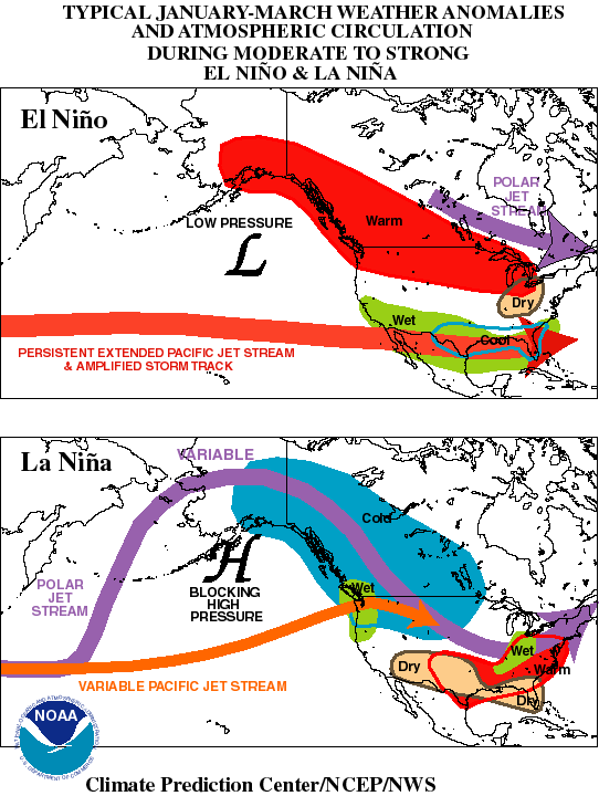
And that is where we are right now.
But as we move through March, April and May, we will be in a neutral pattern which means no direct indication of “Warmer” or “Cooler” is jumping off the page at us meteorologists.
If the transition to a La Nina happens quicker than expected, it may mean a better shot for severe weather later this Spring.
Typically, research indicates a statistically significant increase in tornado activity in the region during La Niña springs. This phase of ENSO tends to foster conditions conducive to severe weather, including more powerful tornadoes that linger longer on the ground and a greater likelihood of large tornadic outbreaks.
But being in a neutral stage, between the two, means there isn’t an indication one way or the other.
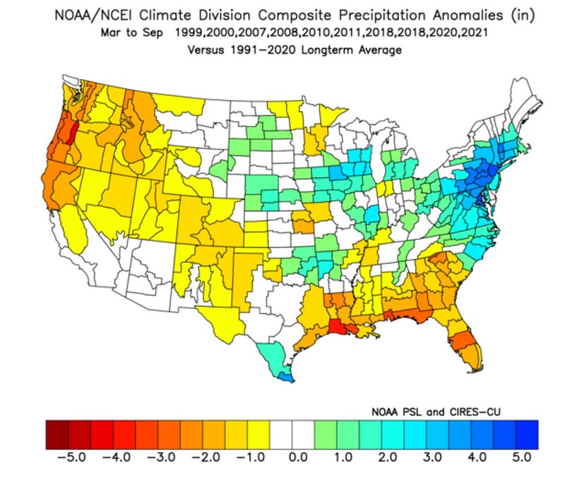
Once we move into late Spring and Summer, though, the anticipation is that we will be in – at least – a weak La Nina. Looking at March through September, La Nina years look to be a bit warmer and drier since 2000.

But drier generally, doesnt mean drier all the time.
Because La Nina years also come with a higher potential for a more active hurricane season. This graphics from the NWS in Jackson, Mississippi explains it pretty easily:
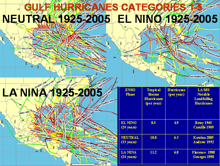
The NWS Jackson writes, “During La Niña, westerly winds high in the atmosphere weaken. This results in an expanded area of low vertical wind shear, allowing more Atlantic hurricanes to develop during La Niña events. La Niña increases the number of hurricanes that develop and allows stronger hurricanes to form. The chances for the continental U.S. and the Caribbean Islands to experience a hurricane increase substantially during La Niña and decrease during El Niño.”
SOUNDS BAD, I KNOW, BUT HANG IN THERE
Well, keep in mind that just like hurricanes and tornadoes – every La Nina is different. Not every one is full of doom and gloom. The most analogous ENSO-switch year may actually be 1973. But 1973 was a way different atmosphere than we have today. So it is tough to draw many – if any – conclusions from that.
The most recent La Nina spring/summer transition after a strong El Nino was in 2016. But the most analogous recent example is probably 2010.
And both 2010 and 2016 didn’t feature particularly active Spring severe weather seasons nor active landfalling hurricane seasons.
But we will have to wait and see how things develop in the coming months.


![[Fig. 1]](https://www.cpc.ncep.noaa.gov/products/analysis_monitoring/enso_advisory/figure01.gif)
![[Fig. 2]](https://www.cpc.ncep.noaa.gov/products/analysis_monitoring/enso_advisory/figure02.gif)
![[Fig. 3]](https://www.cpc.ncep.noaa.gov/products/analysis_monitoring/enso_advisory/figure03.gif)
![[Fig. 4]](https://www.cpc.ncep.noaa.gov/products/analysis_monitoring/enso_advisory/figure04.gif)
![[Fig. 5]](https://www.cpc.ncep.noaa.gov/products/analysis_monitoring/enso_advisory/figure05.gif)
![[Fig. 6]](https://www.cpc.ncep.noaa.gov/products/analysis_monitoring/enso_advisory/figure06.gif)
![[Fig. 7]](https://www.cpc.ncep.noaa.gov/products/analysis_monitoring/enso_advisory/figure07.gif)