That’s right, friends. While I will spend some time talking about La Niña and the hurricane Season, I also posted a “deep tease” about the upcoming winter. Two reasons. The first, I think most of us are tired of 2020 anyway. The second, it will likely have more of a direct impact on your life this winter than this Hurricane Season.
La Niña Watch
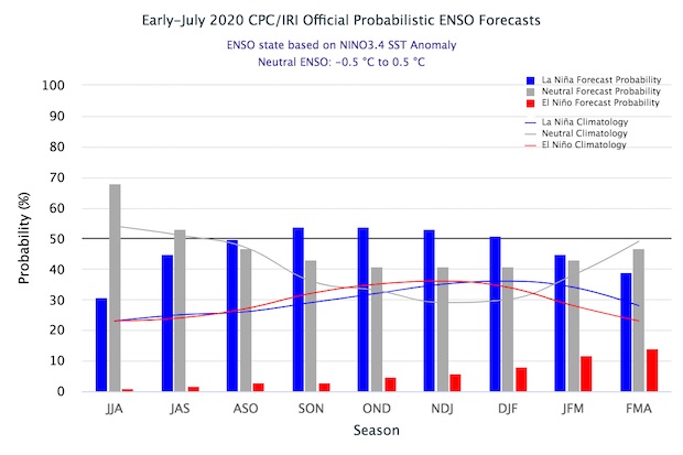
A La Niña Watch means conditions are favorable for the development of the cool phase of ENSO later this year. A “Watch” has been issued in the past for both La Niña and El Niño. So this isn’t – necessarily – a “special” occurrence. In fact, the probability is not terribly high at this point. According to the researchers and forecasters at NOAA, there’s a 50-55% chance of La Niña and a 40-45% chance of neutral conditions. And there is even a 5-10% chance of El Niño.
There have already been indications that cooling is underway. Sea surface temperatures in the equatorial Pacific have shown signs of coling dating abck to early Spring.
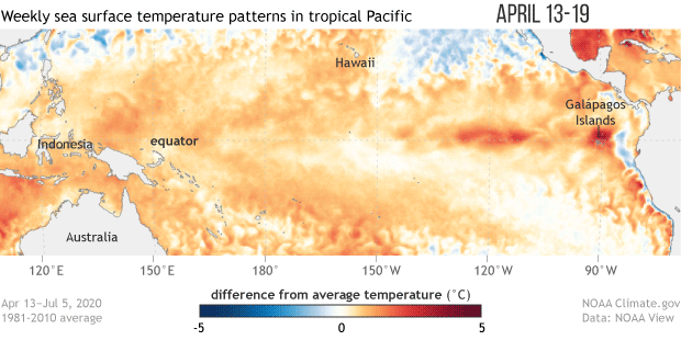
And the cooling trend reall began as far back as the February-March-April timeframe.
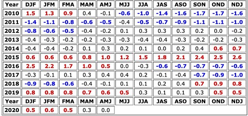
The above chart shows the number of three-month clusters that were El Nino (red), neutral, or La Nina (blue).
Hurricane Season
While a La Nina means cooler water in the Pacific, the reaction from the atmosphere is what meteorologists and forecasters care about. Because the atmospheric reaction to a La Nina is typically reduced wind shear across the parts of the Atlantic where hurricanes develop. That doesn’t guarantee more hurricanes, but does make it easier for them to form.
While the “Watch” had not been issued yet, when the researchers at Colorado State issued an update to their hurricane season forecast they mentioned the cooling water in the Pacific.
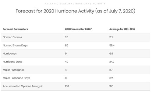
You may chuckle and say, “What do people in Colorado know about hurricanes?!” but they are pretty good at what they do, considering the nature of the prediction they are attempting to make. That said, they do tend to “under-forecast” the season totals.
While some people disagree – and they make good points. I tend to trust the researchers with their general forecasts. I just don’t look at their specific numbers as Gospel.
From Colorado State’s Outlook:
Sea surface temperatures averaged across the eastern and central tropical Pacific are slightly cooler than average, and it appears likely that there will be either cool neutral ENSO or weak La Niña conditions during the remainder of the summer extending into the fall. The tropical Atlantic is somewhat warmer than normal, while the subtropical Atlantic is quite warm. Most of the eastern Atlantic is warmer than normal, and anomalously warm temperatures in this region in June have been typically associated with more active Atlantic hurricane seasons
The tropical Pacific is currently characterized by cool neutral ENSO conditions, with SSTs averaging slightly below-normal across most of the central and eastern tropical Pacific. ENSO events are partially defined by NOAA based on SST anomalies in the Nino 3.4 region, which is defined as 5°S-5°N, 170-120°W. Cool neutral ENSO conditions are defined by anomalies in the Nino 3.4 region between -0.5°C – 0°C. 25 Over the past month, SSTs have trended upward in the Nino 3.4 region, due in large part to localized wind forcing which has inhibited upwelling.
You can read the whole report here.
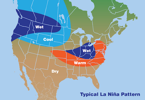
2020-2021 Winter
This gets trickier. Generally during a La Nina, the South is warmer and drier – but there is an asterisks. That is a general statement. It doesn’t mean it can’t get cold. In fact, the giant south Mississippi snowfall in 2017 happened during a very weak La Nina. And drier doesn’t mean it can’t get rainy. There were plenty of examples of flooding in 2018 in the south during a La Nina.
But generally, warmer and drier. And generally, the threat for significant severe weather increases.
I’ll let the NWS explain:
The connections between El Niño/La Niña events and tornado development over the Deep South are not clear cut. However, preliminary research indicates a relationship between ENSO and the occurrence of strong to violent tornado outbreaks over the Southeast United States. In the case of F2 and greater tornadoes, more appear to occur during La Niña months. La Niña seasons are normally associated with warmer than average temperatures in the South, producing a sharper frontal zone between warmer air and the normally cold arctic air to the north. During this time, Deep South weather is more unstable, setting the stage for more tornadoes. A study of the top 15 tornadic outbreaks (at least 40 tornadoes) showed that only one outbreak occurred during an El Niño event. Six occurred during a La Niña event, while the remaining eight occurred during neutral ENSO years.
Some of the more recent La Nina significant severe weather years and seasons: Winter 2017, Winter/Spring 2014, Spring 2011.
So if this forecast holds true, we may be dealing with a rather active winter, too.


