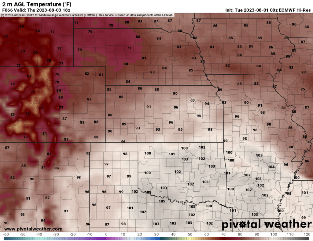
One last week of heat we will have to endure this week before a noticeable, and perhaps refreshing, change in the weather by the end of the weekend and early next week across the state. High pressure over the southern Plains will linger around for a little while longer, keeping our temperatures in the mid 90s to low 100s and allow for Gulf moisture to hang around, maintaining daily heat indices around 100 degrees or higher. Unlike with last week, this high pressure will be gradually waning as the days progress and should allow for daily showers and thunderstorms in some capacity every day by mid this week. By the weekend and entering next week, the presence of high pressure will be completely eroded away and pushed off to the southwest, allowing for cooler temperatures and more consistent chances for rainfall.
Short-Term Outlook
Next few days will still see relatively hot temperatures and largely dry conditions for the majority of central and eastern Kansas. For today, temperatures along and south of I-70 will reach the upper 90s to low 100s by the afternoon with heat indices around the 105°-110° mark. Those north of I-70 will be a bit more fortunate, with temperatures in the mid to upper 80s. Isolated showers and thunderstorms may be possible this evening, with a surface low sitting in central Kansas possibly providing the necessary lift for one or two storms to form. Overall confidence in storm formation is low, but if there is any storms, they would be most likely located east of I-135 and north of US-54. Timing for these storms look to be best maximized between 7-10pm.
Tomorrow will look to be equally as hot as today across the state, with temperatures again back in the 90°-100° range along and south of I-70 and in the low 90s north of I-70. Heat indices will tell a similar story tomorrow and remain in the 105°-110° range with these 90°-100° air temperatures. Scattered, brief showers may again be possible starting at 11am and lasting throughout the day. Confidence again is low to very low as far as formation goes, but if there are going to be any showers, the best places to see them will be mostly west of US-77.
Thursday will see a slight cooldown, if you can call it that, as temperatures will fall back to the 90s in the afternoon as high pressure overhead begins to slightly weaken. Conditions will be drier this day, with mostly cloudy to partly skies overhead. Rain chances will exist again tomorrow as well across the entire area, but overall confidence is still low.
Long-Term Outlook
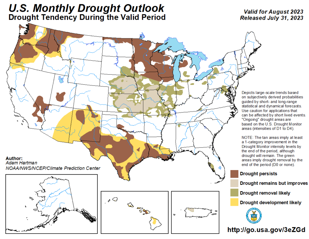
Friday will see temperatures gradually decline before falling off a cliff, relatively speaking, on Sunday as more zonal flow takes over aloft and may see the passage of a couple of disturbances through the state. This will be in response to a cold front sweeping through and punching out the hot temperatures for a while. Temperatures will range between the 80s and 90s over next week, as well as increased rain chances throughout each day, thanks to the west-northwesterly flow in the mid and upper levels. This relatively cooler pattern currently looks to hold through next week.
Agriculture Forecast
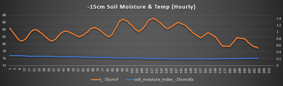
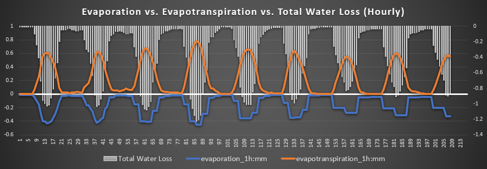
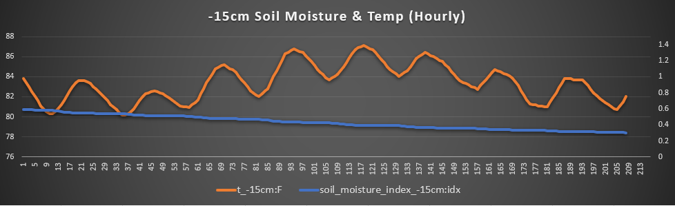
Holton, Mayetta, and Topeka – Out here in northeast Kansas where the drought is the least prevalent, things will be relatively the same until we reach the end of the week. Air temperatures will range in the mid to upper 90s to even low 100s by late this week before we have a cold front move through this weekend and knock us back down into the low to mid 80s. Winds will hover around 5 to 15mph out of the east-southeast before switching to more northerly with this cold front passage. 15cm soil temperatures will hover around 84°F until Thursday/Friday where we could see that peak up to 87°F. By the weekend and early next week, we should see those temperatures steadily fall back into the low 80s. Total water loss rates will range between 0.8 mm/hr to 1.0 mm/hr, with two-day peaks of around 1.2mm/hr Thursday and Friday.

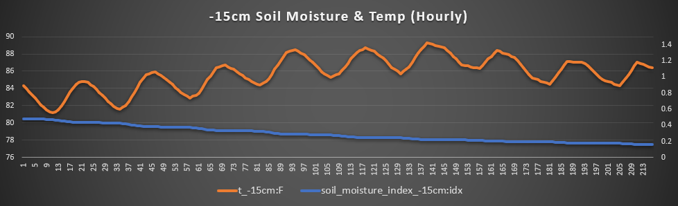
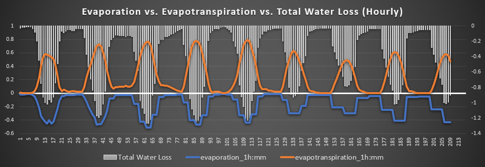
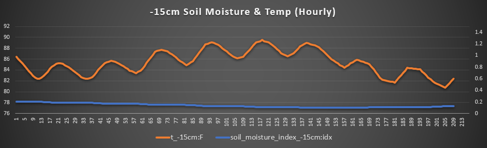
Eureka, Moline, and Howard – Here where drought remains the worst in Kansas, conditions will be slightly warmer for longer here than places further north as well as staying relatively dry. Temperatures will consistently stay at or above 100°F until we reach the weekend, where the passage of this incoming cold front may bring us back to the low 90s. Winds will stay consistent at 5 to 15 mph out of the south and west until we switch to more northeasterly winds by the weekend and early next week. Soil temperatures will steadily rise to a peak of near 90°F Sunday before a slight drop down back to the mid 80s. Total water loss during this timeframe will stay consistently between 1.2 to 1.4 mm/hr before we start slowing that down to 0.8 to 1.0 mm/hr early next week.
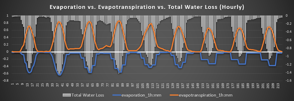
Ottawa, Lawrence, and Olathe – Recovering from the destructive windstorms the other day, soils look to continue drying out for the most part till early next week when greater rain chances are introduced. Temperatures largely will stay between the mid 90s to low 100s for the rest of the week before possibly sinking down slightly to the upper 80s/low 90s by next week. Winds will remain lighter at around 5 to 10 mph out of the south before switching to more northerly winds early next week. Soil temperatures will drop down to a low of around 82°F Wednesday before rising up to around 87°F by Saturday. Total water loss looks to remain steady between 0.8 to 1.0 mm/hr for the next 7 days, with the exception being a peak of 1.2 mm/hr on Thursday.
Osage City, Burlingame, and Lyndon – Outside of maybe a stray thunderstorm Wednesday-Friday, we are looking to stay hot and dry until early next week. Temperatures will steadily rise to around the upper 90s to low 100s through the rest of the week before coming back down the mid to upper 80s by early next week. Winds will stay around 10 to 15 mph out of the south and southwest through the week before changing to a more northerly component early next week. 15 cm soil temperatures will steadily climb before achieving a peak of near 90°F Saturday. Total water loss will continue sticking around 1.0 to 1.2 mm/hr until Saturday, where it then looks to drop somewhat down to between 0.8 to 1.0 mm/hr.
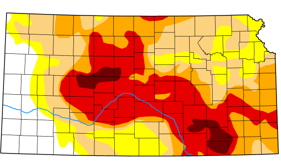
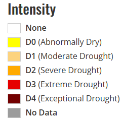
Drought Update
Drought conditions are still relatively similar as compared to the previous update last week. The worst of the drought can still be found in south central/southern Flint Hills region of Kansas. Latest updates from the Climate Prediction Center still favors widespread drought improvement and drought removal across all of Kansas affected by drought, which is in response to increased rainfall potential due to greater opportunities for northwesterly flow aloft.