As a lot of have noticed, the rain has been fairly scarce for the past couple of weeks. While it’s true that we’re entering the driest part of the year for Mississippi, I figured I’d go into why we’re in such a pickle.

Looking at the drought monitor, we can see that that a drought is developing across the Louisiana/Mississippi border and over most of the Four Corners states out west. Why do I mention this? Two strong ridges, both in the Southwest and the Atlantic have a stronghold on the influence of rain. The strength of these ridges inhibits many fronts from moving far enough south to make any impact on us.
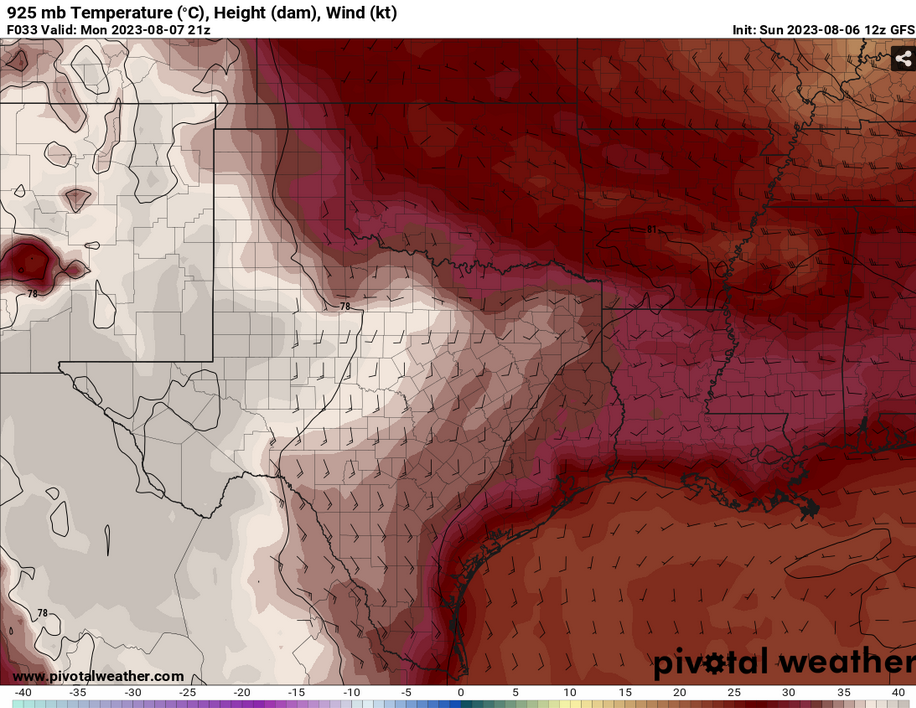

At the mid-levels, the temperature anomaly shows higher temperatures over South Mississippi and Louisiana during the late afternoon. Due to this, most of the rain will miss anywhere south of I-20. Not only this, the temperatures will shoot into the upper 90s to low 100s again.

Looking at today’s models, the shortwave storm I mentioned that would hit on Tuesday looks to have shifted to the east. Judging by the path of the shortwave from Monday, the influence of the two ridges will be the main reason the storm has shifted east. With a more linear upper level influence, there isn’t much of a driving force there. Meanwhile at the surface to the mid-levels, the Atlantic ridge will keep the shortwave just east of us to move the storms towards Alabama, however, there could be a slim chance that we could see a little bit of this rain. Most of it looks to be towards the northeastern Pinebelt, whereas areas near Hattiesburg and south of it may not.
We will keep you updated as the models come in, but for now, it’s very hot and humid, and stay hydrated.
[wpcode id=”41179″]
Regional Day-to-Day Forecast
This Afternoon – Sunny and hot, with a high near 100. Heat index values as high as 107. West wind around 5 mph.
Tonight – Mostly clear, with a low around 79. West wind around 5 mph becoming calm in the evening.
Monday – Sunny and hot, with a high near 100. Heat index values as high as 109. Light west southwest wind increasing to 5 to 10 mph in the morning. Winds could gust as high as 20 mph.
Monday Night – Mostly clear, with a low around 79. West southwest wind around 5 mph becoming calm in the evening.
TuesdayA 40 percent chance of showers and thunderstorms in the afternoon. Mostly sunny and hot, with a high near 97. Calm wind becoming west around 5 mph in the morning.
Tuesday Night – Partly cloudy, with a low around 77. South southeast wind around 5 mph becoming calm.
Wednesday – A 30 percent chance of showers and thunderstorms in the afternoon. Sunny and hot, with a high near 97. Calm wind becoming west southwest around 5 mph in the morning. Winds could gust as high as 20 mph.
Wednesday Night – Partly cloudy, with a low around 78. South wind around 5 mph becoming calm. Winds could gust as high as 20 mph.
Thursday – Sunny and hot, with a high near 98. Calm wind becoming west southwest around 5 mph in the afternoon. Winds could gust as high as 20 mph.
Thursday Night – Mostly clear, with a low around 79.
Friday – A 30 percent chance of showers and thunderstorms. Sunny and hot, with a high near 98.
Friday Night – Mostly clear, with a low around 79.
Saturday – A 30 percent chance of showers and thunderstorms. Sunny and hot, with a high near 97.
[wpcode id=”41149″]


