March 28th and 29th: Severe weather threatens Texas, Louisiana, Mississippi
Author: Nick Lilja
|| Published: 3/28/2018 at 12:23am
As an area of low pressure moves out of Texas and Oklahoma, it will push a cold front across parts of east Texas, Louisiana and Mississippi. The front will be the catalyst for showers and storms to develop.
Some storms may be severe with heavy rain, frequent lightning, damaging wind, hail and the possibility of producing a few tornadoes.
The Breakdown
As noted above, the area of low pressure emerging from Texas will be the problem child the next few days. As a cold front sags through the region it will open the door for severe weather.
The Storm Prediction Center is already highlighting the area for severe weather.
…Wednesday…
An upper-level trough will move into the southern High Plains today as southwest mid-level flow remains in place from the southern Plains eastward into the Mississippi Valley. At the surface, a cold front will advance southeastward across eastern Texas extending northeastward into the Arklatex by afternoon. A moist airmass is forecast ahead of the front with surface dewpoints in the mid to upper 60s F. This should result in a corridor of moderate instability from east Texas into northern Louisiana by early to mid afternoon. Thunderstorms during the day should be focused along and behind the front from the Texas Hill Country into northeast Texas. This convection is forecast to expand in coverage moving across the Arklatex late this afternoon and into the lower to mid Mississippi
Valley early this evening.
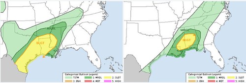
Here are the Day 2 (Wednesday) and Day 3 (Thursday) severe weather risk areas from the Storm Prediction Center
At mid-levels, a speed max is forecast to move across the Arklatex this afternoon and evening. This will create favorable shear profiles for severe storm development. RAP and NAM forecast soundings at Shreveport maintain 0-6 km shear in the 70 to 80 kt range and have long looped hodographs. This should support supercells with the potential for a couple tornadoes late this afternoon into this evening. The most favorable area for tornadoes is forecast from east Texas northeastward to near the Mississippi River along the track of a strengthening 40 to 50 kt low-level jet. Supercells and bowing line segments should be associated with hail and damaging wind gusts. The severe threat is forecast to peak in the early evening but an isolated severe threat may linger into the late evening and overnight period.
…Thursday…
A convective line resulting from overnight activity across southeast TX and western portions of the Lower MS Valley will likely be moving through MS at the beginning of period. This line will likely be weak, owing to limited instability and displacement of the better forcing farther west. As the shortwave trough continues eastward/northeastward, a reinvigoration or redevelopment of the storms within this convective line is anticipated. Storm strength will likely be mitigated by limited instability and the tendency for storms to be undercut but vertical shear is expected to be strong enough (i.e. 0-6 km bulk shear greater than 50 kt) to support rotating updrafts within any storms that are able to persist. Primary severe threat is damaging wind gusts although a brief tornado also appears possible.
Thunderstorms that most through parts of Texas, Louisiana and western Mississippi on Wednesday will likely slow – or even stall out – through the day. Then on Thursday may get a move on again and push through the rest of the southeast.
Threats
The take home: Flooding. Hail. Wind. Tornadoes.
Those are the threats from this storm system. But the threats won’t be for everyone. And the threats won’t be all the time.
Starting at the top: Flooding.
As the front stalls, it may lead to some areas being over-run with excessive rainfall.
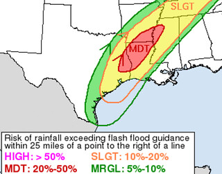
The Weather Prediction Center has highlighted the region with the risk for excessive rainfall
Flash flooding is a concern in the highlighted areas. That said, major flash flooding could become a major concern in the red-shaded area. Model guidance estimates from varying models show the possibility for three to six inches of rainfall on Wednesday. With some models showing as much as 12 inches possible.
That is in an area where some rivers are already in Moderate or Major flood stage.
And nearly 47 river gauges in the lower Mississippi valley – the area under the red shading – are at some sort of flood stage.
Next up: Hail
This threat looks to be isolated to Texas and parts of Louisiana. Specifically on Wednesday afternoon. Hail sizes may be up to two inches in diameter.
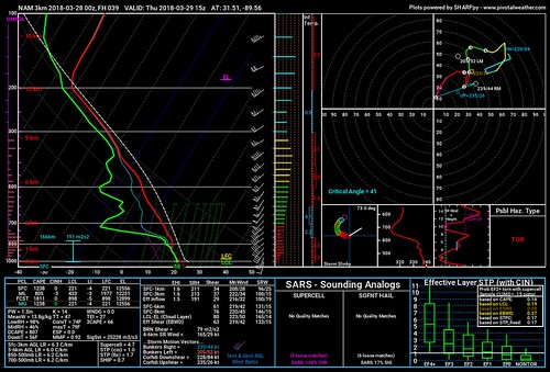
Not much to nerd-out on here. Skew-T charts show some potential for large hail, but greater than two-inch hail doesn’t look likely at this point for the area outlined.
Third on the list: The wind
If there is one thing this system will have, it’s wind. Model guidance continues to show a decent fetch of wind from the south ahead of this system with a fair amount of turning with height.
Nam 3KM Skew-T // Courtesy: Pivotal Weather
If storms develop and can push those winds down tot he surface, wind gusts in excess of 65 to 70mph will be possible during thunderstorms.
Finally: Tornadoes
Okay, so here is the good news and bad news. The good news is that widespread tornadoes aren’t likely Wednesday and Thursday. The bad news is seeing a few tornadoes is likely.
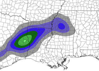
HREF model guidance for probability of highest Updraft Helicity values // Courtesy: spc.noaa.gov
As the SPC highlighted above, there is a threat for a few tornadoes within embedded supercells as well as discrete supercells. The SPC also noted – roughly – the same area I was discussing on the news last night.
The HREF ensemble model guidance suggests that the most robust updraft helicity values will be further west into east Texas and western Louisiana.
That will be where the biggest tornado threat will be. From the bulls-eye of green to the northeast into Louisiana and western Mississippi. This will transition to the east overnight Wednesday and into Thursday morning.
Timing
Wednesday Afternoon: East Texas, Louisiana
Wednesday Evening: Louisiana and western Mississippi
Wednesday overnight into Thursday morning early: eastern Louisiana and western Mississippi
Thursday morning: Central and southern Mississippi
Thursday afternoon: Southern and Eastern Mississippi and western Alabama
What we don’t know yet
Specifics. We are just getting into the time frame where meteorologists can hone in on what to specifically expect for specific areas. That is why the timeline above looks a bit vague and very general. With the next round of data we will be able to be a bit more specific with a bit more confidence.
We’ll have more updates in the morning as new data becomes available! For the latest forecast discussion from the meteorologists with the National Weather Service, head here!
Author of the article:
Nick Lilja
Nick is former television meteorologist with stints in Amarillo and Hattiesburg. During his time in Hattiesburg, he was also an adjunct professor at the University of Southern Mississippi. He is a graduate of both Oregon State and Syracuse University that now calls Houston home. Now that he is retired from TV, he runs this site and its app in his spare time.