The threat for severe weather will shift east on Sunday as the system that is keeping the South Plains on edge today will give Missouri, Arkansas Louisiana, Illinois, Tennessee, Kentucky, and Alabama a reason to keep the NOAA Weather Radio handy.
In fact, the Storm Prediction Center (SPC) is using the word “outbreak” in the discussion describing the severe weather threat on Sunday.
From the SPC:
Overall scenario has not changed much from previous outlook with gradually increasing confidence in a possible outbreak amidst continued limiting factors.
The warm sector will be increasingly broad/moist beneath an eml with lower 60s surface dew points becoming established near the warm front and middle to upper 60s into the lower/mid-ms valleys and arklatex by early evening sun. This combined with initially steep mid-level lapse rates and moderate to strong deep-layer shear will support an expansive area of organized severe storms.
Areas of convection should be ongoing at 12z/sun from parts of ia to ok. Although the bulk this activity should be elevated…It should transition to becoming surface-based as downstream diurnal heating ensues. Clusters of isolated to scattered severe storms will be possible as this lead convection likely develops ewd.
Looking at the most recent model runs, the greatest threat for severe weather in the afternoon is extreme southwestern Missouri, extreme eastern Oklahoma, western Arkansas, western Louisiana and eastern Texas.
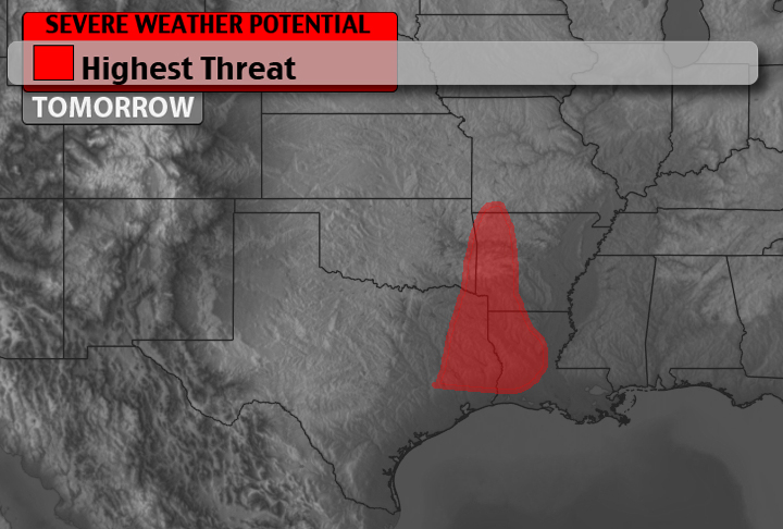
But that isn’t the only place severe weather is possible. Given the atmospheric dynamics, severe weather is also possible in Kansas, Illinois, Kentucky, Tennessee, and Alabama.
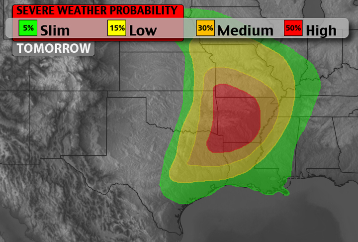
Right now, the main threats for tomorrow will be heavy rains and perhaps some flash flooding, damaging winds in excess of 60MPH, hailstones in excess of golfball-sized and scattered tornadoes embedded within supercells or multicellular clusters. Another concern is with the abundant moisture – dewpoints greater than 60F – is the threat that some tornadoes may become rain-wrapped within the multicellular clusters.
The concerns above will be mainly confined to the orange and red shaded areas in the map above. For the areas shaded in green and yellow, coverage won’t be as widespread. The main threats are still damaging winds and large hail. The threat for an isolated tornado cannot be ruled out and the rain won;t be as torrential.
As the day continues and we work into tomorrow morning, we will continue to monitor this situation closely. A severe weather breakdown with a timetable of events will be posted. If you haven’t already, bookmark the site and follow us on twitter or check us out on facebook. And, as always, check back for updates!


