It’s Saturday. We’ve been talking about today for a while now. And as you wake up this morning, there is the potential for severe weather this afternoon in northwestern Texas, western Oklahoma and south central Kansas. The Storm Prediction Center is about as confident as we are – and have been for the last couple of days.
The main concern for the forecast right now is the amount of daytime heating, the amount of forcing and if the cap will hold.
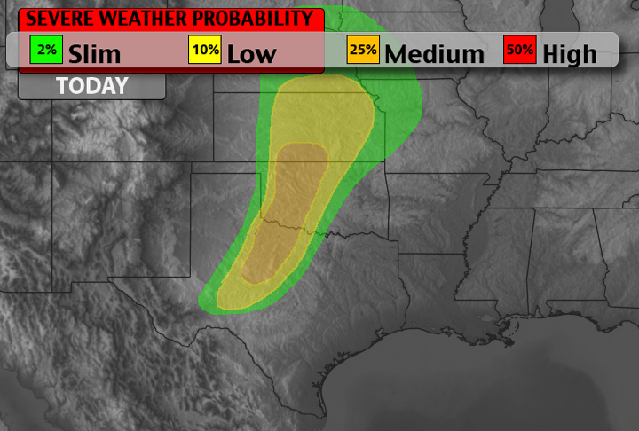
From the SPC:
The deepening lee cyclone and associated strengthening of a sly llj will promote the poleward flux of an increasingly moist boundary layer through the plains warm sector. This process will occur beneath a pronounced eml and associated cap with afternoon mlcape values approaching 2000-3000 j/kg.
Given that the most substantial height falls/dcva attendant to the swrn u.S. Trough will remain to the west of the dryline through the peak of the diurnal heating cycle…Considerable uncertainty exists with regard to the extent of surface-based storm development late this afternoon into evening. The highest probability of occurrence appears to be over nwrn tx/swrn ok along that segment of the dryline which will experience strong daytime heating and development of a deep solenoidal circulation. Here…Steep…Deep-tropospheric lapse rates…20+ f temperature-dewpoint spreads and around 30 kt of effective bulk shear will foster high-based multi- or supercell structures capable of large hail and damaging wind gusts.
By late this evening into tonight…Increasing height falls coupled with strengthening low to mid-tropospheric waa and low-level uplift along the pacific front are expected to foster an increase in mainly elevated tstms across the region. Large hail and damaging wind gusts will accompany the strongest storms owing to the steep midlevel lapse rates…Mucape of 2000-2500 j/kg and strengthening cloud-bearing shear. The greatest risk for a tornado or two will exist with any afternoon/evening supercells which can take advantage of increasing boundary layer moisture and low-level shear after 00-03z over parts of swrn ok/nwrn tx.
Basically, they are saying the same thing we said yesterday – a lot of afternoon severe weather ingredients but there will be a cap and questionable ‘umph’ to get things established.
Right now, this is our latest thinking for the potential for severe weather through Midnight:
The latest model soundings show a mainly wind and hail event for most of the day across the areas shaded above. National Weather Service meteorologists also point to high clouds across the area that may diminish or delay the severe weather threat into the afternoon. As the SPC indicated the best bet for tornado formation will be at or near sunset as the atmosphere moistens up and low-level shear increases. The tornado threat will lower again into the overnight hours as the atmosphere decouples – but it isn’t zero, either.
Timeline
2PM – 5PM
A Severe Thunderstorm Watch may be issued. Isolated storms possible in the area shaded above. Most likely only two to six storms total on the move across an area from Abilene, Texas north to Woodward, Oklahoma and east to Wichita Kansas and Lawton, Oklahoma. The main threats with these cells will be high winds, large hail and cloud to ground lightning.
It’s to be stressed that overall coverage will be rather sparse. And if storms can initiate and develop the chances they turn severe – as outlined above – increases dramatically within a short distance geographically.
5PM – 8PM
Established isolated storms may begin to cluster while other storms fire near Vernon and Wichita Falls, Texas. Places like Lawton, El Reno, and Oklahoma city, Oklahoma will eventually be influenced by these storms. The storms will tend to be more multicellular. The main threats will be high wind and large hail. Heavy rains will also accompany these storms.
Should the isolated storms that fire this afternoon remain isolated, this would be the time for the highest threat of a tornado.
8PM – 12AM
Multicellular storms will likely be fed by low-level shear and the low-level jet. That means they will have very heavy rains, larger hail and very gusty winds. Severe Thunderstorm Warnings will likely be issued for a line of storms if they develop. An isolated tornado within the line cannot be ruled out, but isn’t likely.
In a Nutshell
No need to cancel any afternoon plans across the area. You are probably still safe to get a round of golf in, or enjoy an afternoon barbeque. And your kids can still suit up for hteir Little League game.
But please keep an eye to the sky. And please have a plan on what you will do if severe weather strikes. If storms develop in your area, and you are in the shaded areas above, keep in mind that storms could increase in severity rapidly. A couple of cumulus clouds can turn to baseball hail quickly today given the atmospheric dynamics.
We will continue to update this throughout the day. Be sure to follow us on twitter: @nqlblq, @AlomarSharpe, and @NickLiljaWx.


