Remember back in December and January when it just kept raining. Just raining and raining and raining. And we all complained, in Mississippi, ‘where is the sun?” we asked.
I will never complain about repetitive rounds of rain again.
Okay, with that said, there is a chance for more severe weather on Sunday. This round of storms will be a bit different than last weekend’s severe weather. Sunday’s severe weather will feature clusters of storms a the development of an MCS (Mesoscale Convective System). Because of this, there will be multiple chances within the line of storms for severe weather to develop and – unfortunately – for tornadoes to develop.
From the SPC
…Lower Mississippi Valley/Southeast…
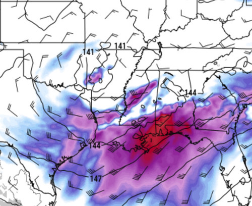
A potent upper-level trough will move quickly eastward across the southern Plains today as a 60 to 75 kt mid-level jet moves eastward across the Southeast. Ahead of the system, a corridor of moderate to strong instability is forecast to develop from parts of the lower Mississippi Valley eastward across much of the Southeast. This combined with steep mid-level lapse rates and strong low-level shear will be very favorable for severe storms. As the mid-level jet moves eastward into the Southeast, a regional outbreak of severe weather including tornadoes appears likely from parts of the lower Mississippi Valley eastward across parts of Mississippi, Alabama and Georgia. The greatest threat for tornadoes is expected to last from late morning through the afternoon and evening into the overnight period.
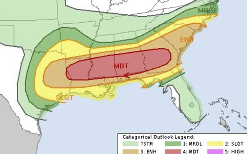
At the start of the period, a moist and unstable warm sector will be in place from southeast Texas eastward across much of the Gulf Coast. The northern edge of the moist sector will gradually move northward as moisture advection occurs. A severe convective cluster appears likely to be ongoing this morning from east Texas into the Arklatex where large hail and wind damage will be possible. As surface temperatures warm this morning, a threat for hailstones greater than 2 inches in diameter will be possible. If some of the storms become surface-based, a tornado threat could also develop. Eastward from this complex, an undisturbed moist sector will exist from south-central Louisiana eastward across the southern half of Mississippi, the southern half of Alabama into southern Georgia. RAP forecast soundings by early to mid afternoon along this corridor have MLCAPE of 2000 to 3000 J/kg with 0-6 km shear in the 50 to 60 kt range. This environment will likely be very favorable for supercells and tornadoes. 0-3 storm-relative helicities are forecast to be favorable being maintained in the 300 to 400 m2/s2 range in the late afternoon as a low-level jet becomes focused ahead of the approaching system.
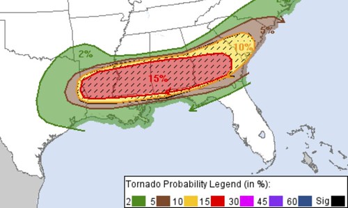
The first round of severe storms is expected to move eastward out of east Texas into western Louisiana late this morning. Large hail and wind damage should be the main threat initially. But as the storms mature, tornadoes will be possible along the southern edge of the complex with supercells that become surface-based. This convective complex is expected to move eastward along a warm front across central Mississippi into west-central Alabama during the mid to late afternoon. The stronger and more dominant supercells that interact with the warm front may produce tornadoes, some potentially strong, along with wind damage and large hail.
Further south across southern Mississippi and southwestern Alabama, the airmass is expected to remain undisturbed through mid afternoon with a corridor of strong instability setting up from southern Mississippi eastward into south-central Alabama. Supercells are possible ahead of the main complex along this corridor in the late afternoon as large-scale ascent increases ahead of the upper-level trough. At this time, the mid-level jet will become coupled with the low-level jet, creating a favorable combination of lift and shear for potentially strong tornadoes. The greatest potential for a regional cluster of tornadoes is forecast from just southeast of Jackson, Mississippi and Hattiesburg, Mississippi eastward across southwest and south-central Alabama.
In addition to the tornado threat, large hail and wind damage will be likely across a large part of the Southeast this afternoon and evening. The wind-damage threat is expected to increase as an MCS moves eastward across southeastern Alabama and into south-central Georgia by early this evening. Squall-line development will be possible ahead of the cold front tonight from central Georgia into the Carolinas, where a wind damage, large hail and a tornado threat will be possible.
The Karrie Meter
Is looking a bit higher with the overnight data (late Saturday and into Sunday morning) coming down.
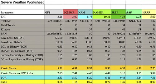
The Final Number: 6.91
That converts back to a 3.4 – or somewhere between a Moderate and Enhanced Risk. And that is basically where we are in South Mississippi.
The Tornado Ratio number that I used a few weeks ago, is coming in lower on some models and higher on others. Since it isn’t higher or lower across the board, the numbers doesn’t greatly add to or subtract from the confidence in tornadoes.
That said, the fact that the Final Number for the ratio is so close to “1” does lead me to believe that at least one tornado is likely. Beyond that, though, the number doesn’t help as much in this particular case.
The Analogs
The CIPS Analogs have done a good job identifying the area of potential severe weather going back to last week. It continues to shift the main area of concern around regionally, but has bulls-eyed southern Mississippi with a decent shot for storms for the last five or six days.
Here is a look at the numbers from Saturday’s data:

That is the data showing the potential for seeing a severe storm. Here is the data for the potential for seeing a tornado:
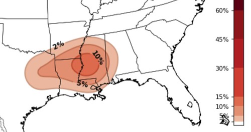
To differentiate real quick. This is just data, not a forecast. This data is what meteorologists use in order to make the forecast.
There is some good info to pull out of this. While the threat for severe weather is high, the CIPS Analogs shows that the threat for a tornado iese lower. This indicates that wind and hail may be the main concern for most people during the day on Sunday.
Again, just data, not a forecast.
More Data
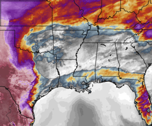
It looks like the low-level area of low pressure that develops tomorrow on the backside of the storms near the base of the trough is going to be a bit more robust than previous model data indicated. This could increase the low-level flow off the Gulf of MExico – particularly around sunset and into the overnight hours. Depending on where convection is aligned at this point, it may increase the severe weather risk as the low-level jet starts cranking.
The other interesting bit of data is the boundary between low LCLs and higher LCLs.
The LCL, or lifted condensation level, helps forecasters out with a lot. In this situation, I use it to help estimate the tornado threat. Because low LCLs are often needed for tornado development. How low is low? It depends on a lot. For southern Mississippi, historically 600 meters and lower is a good number for tornadoes to develop – if all other parameters are met.
In this case, parts of the Pine Belt will be right along the boundary between numbers in the 1500 meters range and numbers in the 150 meters range. A tight gradient like that is usually an indication that some front or cluster of storms will be nearby.
In this case, storms will be the reason.
The question becomes just how low will the LCLs get on the southern edge of the storms. Data suggests that numbers will range from 650 meters to 1000 meters. And that is still in the range of tornado development for the area, given the other parameters that will be in place.
That is why I mentioned on facebook that the “will I be under a tornado warning?” threat, in this situation, is actually higher than last Sunday. But the potency of the tornadoes should be lower.
The Timeline & Threats
Rain and storms will begin as early as 10am. It looks like the threat for severe weather will begin around 1pm and last through about 11pm at night.
The main threats….
| THREATS | THREAT LEVEL (out of 5) | NOTES |
| Flooding | 2 | Up to 3″ of rain possible |
| Wind | 4 | Up to 70mph gusts possible |
| Hail | 3 | Up to tennis ball-sized |
| Tornado | 3 | Up to EF-3 possible |
| Lightning | 4 | Frequent lightning |
And again, I tend to think that the chance you are under a Tornado Warning is actually higher Sunday than last week. But the strength of the tornadoes this week will not be as potent as last week.
That said, an EF-3 is still a powerfully destructive tornado. Even an EF-2 will do considerable damage to structures. So please take these warnings seriously.
The Bottom Line
Storms will be possible Sunday afternoon and evening. Most of these storms are going to feature very heavy rain, a lot of lightning, some very gusty wind, and some hail. There is chance that the area sees another tornado, maybe a few. And those could be as strong as EF-3. But the chance for a devastating, long-track tornado like last weekend is much lower.
A lot like last time, here is a breakdown of who sees what…
Everywhere: Rain & wind up to 40mph
Many places: Rain, lightning, wind up to 60mph
Some places: Rain, flash flooding, frequent lightning, wind gusts up to 65mph and hail
Few places: Very heavy rain, flash flooding, frequent lightning, wind gusts up to 65mph, hail, and a tornado
The thing that we are going to work at figuring out during the next 12 hours is where the MCS develops, how it progresses and what happens south of where it goes.


Thank you Nick for always keeping us informed! On Dec.16, 2019, our family survived a tornado, and as we took shelter, your voice was calling out road names leading up to our location-we thank God for you and the excellent job you do!
Thank you Nick. You’ve covered my area this time. I’m in the gulf coast Area and it looks like our chances of severe will be more robust than last weekend was. I really appreciate the science & still seeing the Karrie meter helps to get a better grasp. I can prepare accordingly.