The Storm Prediction Center has up’d the Risk level to a Moderate Risk for section of the South for late Friday and into Saturday morning. This is a “4” on the 1-to-5 scale where “5” is the highest risk for the most significant severe weather.

The main concern for the Moderate Risk area is going to be the potential for straight-line wind in excess of 80mph. But storms will also pack heavy rain, localized flash flooding, hail up to the size of baseballs (especially north) and the potential for a few tornadoes.
From the SPC
The Moderate Risk was issued to highlight the threat for hail in some areas and the potential for some very strong wind in others.

The SPC Discussion was rather robust this morning, full of some great information:
… SYNOPSIS…
In mid/upper levels, a split-flow pattern will be maintained over the central CONUS, as one cyclone ejects out of a broader-scale trough causing the split, and another takes its place. The leading cyclone — initially centered near LSE — is forecast to weaken gradually to an open-wave trough and head northeastward over Upper MI and Lake Superior overnight. Upstream, a strong shortwave trough was apparent in moisture-channel imagery from eastern MT southward to central CO.
This feature will dig southeastward across the central Plains today and this evening, before pivoting eastward tonight as a closed cyclone, across parts of the lower Missouri Valley. By 12Z, the associated 500-mb low should be located near the KS/MO line south of MKC. Farther south, a broad area of strong cyclonic flow aloft will spread eastward across the outlook area, with embedded, closely spaced perturbations now evident over southwestern/central NM and the TX Panhandle.
These perturbations will move across OK and south TX today. Tonight, they should reach parts of TN/MS/LA, likely blending into convectively generated vorticity fields. The broad left-exit region of a cyclonically curved, 250-mb subtropical jet, also exhibiting pronounced difluence, also will shift eastward over much of central/north TX and LA today and tonight toward the Delta region. At the surface, 11Z analysis showed an occluded, elongated area of low pressure across northwestern WI to northern IA. An occluded front was drawn from the northern part across Lake Superior and Lower MI, with weakening/quasistationary front across western OH, eastern portions of TN/KY, and northern AL.
A warm front extended across Lake Erie, eastern WV, and southwestern/southern VA near the NC line. This boundary will move slowly northward over southern/ central VA today. A cold front extended across southern IA, northwestern MO, central/western KS, and southeastern CO. A marine/warm front extended from a low over northwest TX across north-central TX, central LA, and southern portions of MS/AL. This boundary will move northward across southern /eastern OK, AR, and central MS/AL through the day.
The northern low should consolidate in form but continue to fill, and move northeastward over ON. Meanwhile, a second low is expected to develop along the front today near the dryline intersection, perhaps evolving out of the initial/prefrontal low over northwest TX. The resulting low should deepen as the next mid/upper cyclone approaches, and move northeastward to near STL by 12Z tomorrow.
By that time, the cold front should extend from the low southward down the Mississippi Valley to near BTR, then southwestward across mid/upper TX coastal waters to deep south TX. …Southern Plains to Arklatex/Mid-South/Delta regions… Episodes of severe thunderstorms are expected today into this evening between eastern OK, north TX and Mississippi, resulting in large (locally very large) hail, severe gusts and several tornadoes. This is a complex scenario with an assortment of mesoscale possibilities more diverse than the number of models and ensemble members available.
Progs somewhat inconsistently depict early initiation and evolution of the convection across this region, whether near the front in OK (a very plausible consensus theme), on the dryline (more isolated/conditional due to strong capping), and in the warm sector (highly variable). Multiple episodes of strong-severe thunderstorms may move over any given spot through tonight.
This outlook represents both:
1. The potential for overlapping areas of severe at different times through the day and evening as different areas of convection evolve, but also:
2. A scenario that most progs reasonably do converge upon despite early differences: a dominant QLCS/MCS evolving out of convection initiating in OK and/or northeast TX, then moving east-southeastward to southeastward over the Arklatex to Delta regions, organizing a well-developed cold pool, and producing a swath of severe wind.Whether or not this event will qualify as a derecho is a semantic exercise, and likely regulated by mesoscale convective/boundary processes yet to become apparent. Regardless, hurricane-force convective gusts are a threat with any such complex, in the Enhanced and Moderate areas. Also, because both the probable QLCS and any preceding supercell(s) will encounter an environment of moderate- strong buoyancy, steep midlevel lapse rates around the eastern rim of an EML, enlarged low-level hodographs, and favorable vertical shear, tornadoes also are expected.
Peak preconvective MLCAPE across the warm sector commonly should be in the 2000-3000 J/kg range, amidst 40-55-kt effective-shear magnitudes. As one or more MCSs plow cold pools into this environment, they should be maintained southeastward toward southern MS/AL tonight, continuing a wind-damage and sporadic tornado threat.
…Central Gulf Coast to AL/GA this morning/afternoon…
Widely scattered to scattered thunderstorms should develop from mid/late morning through this afternoon, with a threat for sporadic large hail and damaging gusts. A conditional, localized tornado threat also may develop.
For near-term coverage, please see SPC mesoscale discussion 338. Midlevel lapse rates will be less than in the more EML-influenced air mass of the Plains/Delta area. Still, rich low-level moisture spreading inland, combined with areas of diurnal heating (tempered in pace by mid/upper cloud cover from upstream convection), will weaken MLCINH and yield favorable surface-based buoyancy. Meanwhile, low-level shear will be maximized near the marine frontal zone, though weak absolute speeds will limit hodograph size somewhat.
Modified 12Z RAOBs and forecast soundings from midday through afternoon indicate around 1500-2000 J/kg MLCAPE is possible, with 35-45 kt effective-shear magnitudes. Effective SRH will range from around 200-250 J/kg on the front to around 100-1-50 J/kg coastward in the warm sector. With upper support meager in this area, but also modest MLCINH, convective coverage along and south of the front is uncertain.
Courtesy: spc.noaa..gov
The individual threats break down like this:


Model data
The parameter space for severe weather overnight is going to be rather boust. And model guidance continues to show a one-two punch with a few isolated storms firing up between 10p and 3a across south Mississippi followed by a line of storms kicking through the area between 3am and 7am.
The latest 12z HRRR radar estimate data, shown above, highlights the double-decker nature of this system. With even an earlier round of rain across parts of Alabama and the Florida panhandle.
The good news, regarding the tornado threat, is that there are no pronounced ‘lone’ Updraft Helicity streaks within the model guidance.
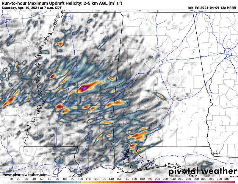
So while the above image does show multiple areas where the computer model thinks storms will be rotating, there isn’t one or two “main” areas that the computer has picked out as a long supercell capable of producing a large and extremely destructive tornado.
Does that mean we are 100% in the clear from tornadoes? No. Far from it. But it is “good news” because it means there isn’t any glaring data within the model to show that as a definite outcome.
Threats and Timeline
For south Mississippi, between the two rounds of storms, the main concerns are…
– Heavy rain
– Localized flash flooding (Between 2″ and 4″ in general by the time it is all said and done with some places getting up to 6″ of rain.)
Wind gusts up to 65mph (for most) with some spots experiencing wind gusts up to 80mph potentially
– Hail up to the size of golf balls
– A few tornadoes
The timeline for storms is…
Regular Thunderstorms: 6p – 8a
Severe Thunderstorms: 10p – 6a
Tornado threat: 11p – 6a
“Strong” tornado threat: 11p – 3a
Wind threat: 10p – 6a
80mph Wind threat: 3a – 6a
Hail threat: 10p-3a
Flooding threat: 12a – 8a
Interstate 10 corridor
10p – 2a: Isolated showers and storms, some severe. During this time the main concerns will be heavy rain, frequent lightning, wind gusts up to 65mph, hail up to the size of golf balls, and a tornado (up to EF-3 in strength)
2a – 6a: A line of storms will move through the area with very heavy rain, frequent lightning, wind gusts up to 80mph, and the potential to produce brief tornadoes (up to EF-1 in strength).
6a – 10a: Lingering rain showers and thunder, skies begin to clear by mid-morning. Severe threat over.
Highway 84 corridor
10p – 2a: Isolated showers and storms, some severe. During this time the main concerns will be heavy rain, frequent lightning, wind gusts up to 65mph, hail up to the size of golf balls, and a tornado (up to EF-3 in strength)
2a – 6a: A line of storms will move through the area with very heavy rain, frequent lightning, wind gusts up to 80mph, and the potential to produce brief tornadoes (up to EF-1 in strength).
6a – 10a: Lingering rain showers and thunder, skies begin to clear by mid-morning. Severe threat over.
Highway 98 corridor
10p – 2a: Isolated showers and storms, some severe. During this time the main concerns will be heavy rain, frequent lightning, wind gusts up to 65mph, hail up to the size of golf balls, and a tornado (up to EF-3 in strength)
2a – 6a: Isolated storms continue through 3am, then a line of storms will move through the area with very heavy rain, frequent lightning, wind gusts up to 80mph, and the potential to produce brief tornadoes (up to EF-1 in strength).
6a – 10a: Lingering rain showers and thunder. Severe threat over.
Highway 26 corridor
10p – 2a: Isolated showers and storms, some severe. During this time the main concerns will be heavy rain, frequent lightning, wind gusts up to 65mph, and a brief tornado (up to EF-1 in strength)
2a – 6a: Isolated storms continue through 4am, then a line of storms will move through the area with very heavy rain, frequent lightning, wind gusts up to 80mph, and the potential to produce brief tornadoes (up to EF-1 in strength).
6a – 10a: Lingering storms closer to the coast. Severe threat over.
The Bottom Line
Showers, thunderstorms and the potential for severe weather is going to begin this evening and into the overnight hours. The main concern is going to be wind. A’lotta wind. In fact, preparing to be without power for at least six hours may be a good bet. It won’t happen to everyone, but better to be prepared!
On top of the wind, there is also a concern for very heavy rain, frequent lightning, hail up to the size of golf balls and a few tornadoes – up to EF-3 in strength.
Have a severe weather plan in place. Know what you would do if a Severe Thunderstorm Warning or a Tornado Warning was issued for your area. Where would you take cover? Do you have the necessary items with you? Overnight, make sure you have a way to get alerts from the National Weather Service that will wake you up. A NOAA Weather Radio or an app for your phone that will alert you (loudly) is best.
Again, I want to stress that this doesn’t look like a knock-down drag-out tornado event. But the potential for 80mph straight-line wind is no different than an EF-0 tornado. So please take the wind seriously. Trees, most times, don’t appreciate a 40mph wind. Doubling that wind speed means there will be many trees coming down as well as a plethora of power outages.
So make plans now! That way you are ready to go if the worst of the weather knocks on your door.


THIS is what I will miss the most (next to your humor) starting on April 24th. I feel that we will not see this after that. Just a little ‘concerning’, is all.