This is probably going to seem repetitive, but this is the hand that Mother Nature dealt us: Summertime is here and a lot of the days are about to start feeling the same.
As has been stated in multiple recent forecasts, the upper level ridging is set to stay in place for most of the foreseeable future, leading to a pretty boring forecast. Honestly, given that we’re a few weeks into the hurricane season, boring isn’t necessarily a bad thing.
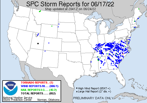
You may recall reading a discussion about strong storm complexes called MCS’s. These are storm complexes that usually form on the Northern end of ridges, and they can sometimes go basically undetected by weather models. Yesterday, we had one heck of an MCS impact a good part of the country, starting Thursday night near Omaha, NE, and continuing all the way into the Atlantic Ocean.
Though it didn’t impact this part of the country, I still find it fascinating to see how these systems can evolve and cover so much real estate. Each blue dot below is a strong wind report.
Looking at the short term for our own area, some drier air is (finally) set to start filtering in later this afternoon and evening. As the ridge slides to the west very briefly, the winds will shift to bring us some drier Canadian air. Still just as hot as it’s been, but tomorrow does look more comfortable as a result of the less humid air. It would definitely be the best day to catch up on mowing, or whatever other outdoor work you’ve got to do.
But, before we can get to that, we have a storm threat for tonight. Nothing is free, so this dose of drier air does come with a cost-a few spotty strong thunderstorms. As of Friday evening, the SPC has outlined a good chunk of the state in a marginal risk of severe thunderstorms. Those are pretty common and mostly reserved for very isolated severe storms that aren’t super intense or organized.

Most people won’t see any rain tomorrow. A few may see a thunderstorm in the afternoon but a majority will stay dry and won’t see impacts from severe weather. To the unlucky few that do see storms, heavy rain and strong winds will be possible. If you’ve lived here in the summer before, you know the drill, because that’s just how it always is.
In addition to storms, there is a Heat Advisory in effect from now until 8pm this evening. We’ll have to wait and see what the Weather Service is going to do, but I suspect we’ll have more of those advisories posted for next week.
Once our storm threat is over, and the dry air moves through Sunday, it’s looking like more hot and humid weather is coming later on in the week.

A strong upper level ridge (stronger than last week’s) is forecast to set up over the Tennessee Valley early into next week. Since this ridge is stronger, it will do a better job at keeping rain chances at a minimum this week, which is why the forecast looks a lot drier.
Take note if you run a backyard garden, or have any outdoor plants – it won’t take much more hot and dry weather to push us into a drought! Much of the Southwestern part of the state is running at about 25% (Red area below) of their average rainfall through the first two weeks of June, so drought may become a problem for some folks. Fingers crossed that it won’t have many impacts.

The only real chance of rain this upcoming week looks to be Friday, where the GFS computer model is showing a weak disturbance swinging around the back side of the ridge, moving from East to West. That might provide just enough lift in the atmosphere for some rain or storms, but that’s six days in the future and subject to change. Lots of change.
Day-to-Day Forecast
Today
Partly cloudy, with a 40-percent chance of very isolated afternoon storms, which may be strong. Highs in the upper 90s. The heat index may reach 106F. A Heat Advisory is in effect through 8pm.
Tonight
Mostly clear, with a 30-percent chance of rain in the evening, diminishing after dark. Lows in the mid 70s.
Tomorrow
Mostly sunny. Noticeably less humid. Highs in the mid-90s.
Tomorrow Night
Mostly clear. Lows in the low 70s.
Monday
Mostly sunny. Highs in the mid 90s. The heat index may reach 100F.
Monday Night
Mostly clear. Lows in the low 70s.
Tuesday
Mostly sunny. Highs in the mid 90s. The heat index may reach 100F.
Tuesday Night
Mostly clear. Lows in the mid 70s.
Wednesday
Mostly sunny. Highs in the upper 90s. The heat index may reach 105F.
Wednesday Night
Mostly clear. Lows in the mid 70s.
Thursday
Mostly sunny. Highs around 100F. The heat index may reach 107F.
Thursday Night
Partly cloudy. Lows in the mid-70s.
Friday
Partly cloudy, with a 30-percent chance of afternoon storms. Highs around 100F. The heat index may reach 105F.
Friday Night
Partly cloudy, with a 30-percent chance of evening storms. Lows in the mid-70s.


