Looking at some of the morning data, it look slike we will have another line of showers and storms kick through the area around midday. The line is currently back toward Lake Charles, Louisiana and will be marching out direction during the next 6 hours.
The line should get to some of our western counties by around 10a and move all the way through by about 4p.


The estimated radar images above are from the HRRR model which show the lines of storms falling apart as they move, from west to east, across the area. Part of this is due to the fact that the atmosphere was pretty-well worked over yesterday and because the shortwave associated with the storms will swing through to the north pretty quick.

The image here shows the storms actually out-run the front. And when they lose that forcing, they lose the ability to maintain those updrafts and they fall apart.
That said, I think there may be a brief window of opportunity between about 10a and 2p where storms will have the chance to turn severe. That would come along with a chance for brief very heavy rain, lightning, wind gusts up to 65mph, small hail and the chance to produce a tornado.
The tornado risk is relatively low, but if the line of storms ends up broken up and they meander a bit from their forward motion, I think we introduce a localized environment that would be pretty conducive for brief spin-up tornadoes.
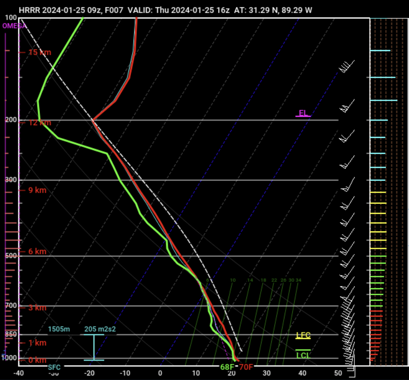
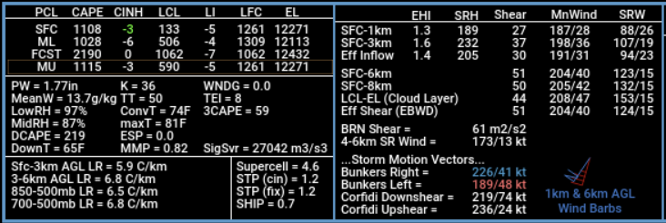
The Skew-T data (above, left) shows some reasonable instability, an EIL that is on surface-based, as well as enough shear and helicity to produce a tornado in our area. There isn’t a “Big” threat, but it is certainly there.
Once the storms kick through we should calm things down for the night, but we will have another shot for rain and storms as we move through the weekend.
REGIONAL DAY TO DAY FORECAST
Thursday: Areas of fog in the morning. Showers with a chance of thunderstorms. Locally heavy rainfall possible. Highs in the lower 70s. South winds 10 to 15 mph. Chance of rain 90 percent.
Thursday Night: Cloudy with a chance of thunderstorms. A chance of showers in the evening, then showers likely after midnight. Patchy fog. Lows around 60. South winds around 5 mph. Chance of rain 70 percent.
Friday: A chance of thunderstorms. Showers. Highs around 70. Southeast winds 5 to 10 mph. Chance of rain 90 percent.
Friday Night: Cloudy with a chance of thunderstorms. A chance of showers in the evening, then showers likely after midnight. Patchy fog after midnight. Near steady temperature around 60. Southeast winds 5 to 10 mph. Chance of rain 70 percent.
Saturday: Mostly cloudy with showers with a chance of thunderstorms in the morning, then partly sunny with a slight chance of showers and thunderstorms in the afternoon. Highs in the mid 70s. Chance of rain 80 percent.
Saturday Night: Mostly clear in the evening, then becoming partly cloudy. Cooler with lows in the upper 40s.
Sunday: Mostly sunny. Much cooler with highs in the upper 50s.
Sunday Night: Partly cloudy. Lows in the upper 30s.
Monday: Sunny. Highs around 60.
Monday Night: Mostly clear. Lows in the mid 30s.
Tuesday: Sunny. Highs in the lower 60s.
Tuesday Night: Mostly clear in the evening, then becoming partly cloudy. Lows in the upper 30s.
Wednesday: Mostly sunny. Highs in the mid 60s.


