It is another foggy morning. And it isn’t just us. It is a LOT of places. The last four days could be among the foggiest days in recorded US history.
Pretty crazy!
For us, it looks like we will have a partly-dry day today before more rain moves into the area this afternoon, evening, and overnight tonight and into tomorrow. And the amount of rain you see will depend on where you live. The farther to the southeast you lives, the better the shot for rain, the farther northwest, the drier you’ll be.
Just a quick reminder that the coverage area for this blog’s / app’s detailed discussions are generally the area outlined in green.

And when the interns are around, it does spread to cover a larger area (almost all of the orange area).
So this is how things break down through the day today: A warm front should lift to the north and offer the shot for some light to moderate raina nd rumbles of thunder through the afternoon and evening.


But we may end up with a bit of a lull from about 11p tonight though about 4a tomorrow morning, before more showers and storms move through. I think there will still be some drizzle and light rain here and there, but we wouldn’t ahve to worry about moderate or heavy rainfall or and kind of flooding.
Then through tomorrow, we get into a situation here things fire up around us, but given that the atmosphere has been pretty well turned-over the last few days, it looks like things may struggle to develop around us.


Also, as you can see on the radar images, I’ve used very general and relative times like “Morning” and “Evening” instead of specific times. That is on purpose. With this system, as it develops and move through the area, I don’t think the model guidance has a very good handle on the specific timeline of events. So I’m hesitant to give you guys any specific timeline, too.
The other reason I thinkt he models are struggling witht he timeline is that this system won’t get fully organized until it zips past us. So the models are looking at something that isn’t there yet and trying to figure out when it will develop and where it will go. A bit like during hurricane season when we say we can’t produce a good forecast for a hurricane until it forms, same goes with these winter-time systems. Usually, they develop way out int he PAcific and we see them coming. This one is going to develop during the next 24 hours.
By the time it is all said and done, it looks like some of the heaviest rain should remain offshore, but there is a chance that some folks close to the coast may see a shot at another 2″ to 4″ of rain.
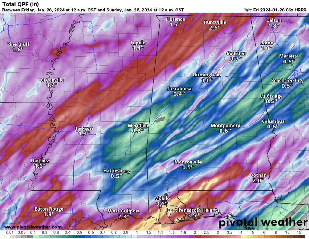
But, generally, it looks like another 0.5″ to 2.5″ of rain is possible.
REGIONAL DAY TO DAY FORECAST
Friday: Areas of dense fog in the morning. Mostly cloudy with a chance of thunderstorms. Showers, mainly in the morning. Highs in the lower 70s. Southeast winds around 5 mph. Chance of rain 90 percent.
Friday Night: A chance of thunderstorms. Showers. Areas of dense fog after midnight. Near steady temperature in the lower 60s. Southeast winds 5 to 10 mph. Chance of rain 80 percent.
Saturday: Mostly cloudy. Areas of dense fog in the morning. Showers with a chance of thunderstorms in the morning, then a chance of showers with a slight chance of thunderstorms in the afternoon. Highs in the lower 70s. South winds 10 to 15 mph, becoming southwest in the afternoon. Chance of rain 90 percent.
Saturday Night: Mostly cloudy. Much cooler. Less humid with lows in the upper 40s. Northwest winds 10 to 15 mph with gusts up to 25 mph.
Sunday: Mostly cloudy in the morning, then becoming partly sunny. Much cooler with highs in the mid 50s.
Sunday Night: Partly cloudy. Cooler with lows in the upper 30s.
Monday: Sunny. Highs around 60.
Monday Night: Mostly clear. Lows in the mid 30s.
Tuesday: Sunny. Highs in the mid 60s.
Tuesday Night: Partly cloudy in the evening, then becoming mostly clear. Lows in the lower 40s.
Wednesday: Mostly sunny. Highs in the mid 60s.
Wednesday Night: Partly cloudy in the evening, then becoming mostly cloudy. Lows in the lower 40s.
Thursday: Partly sunny. Highs in the mid 60s.


