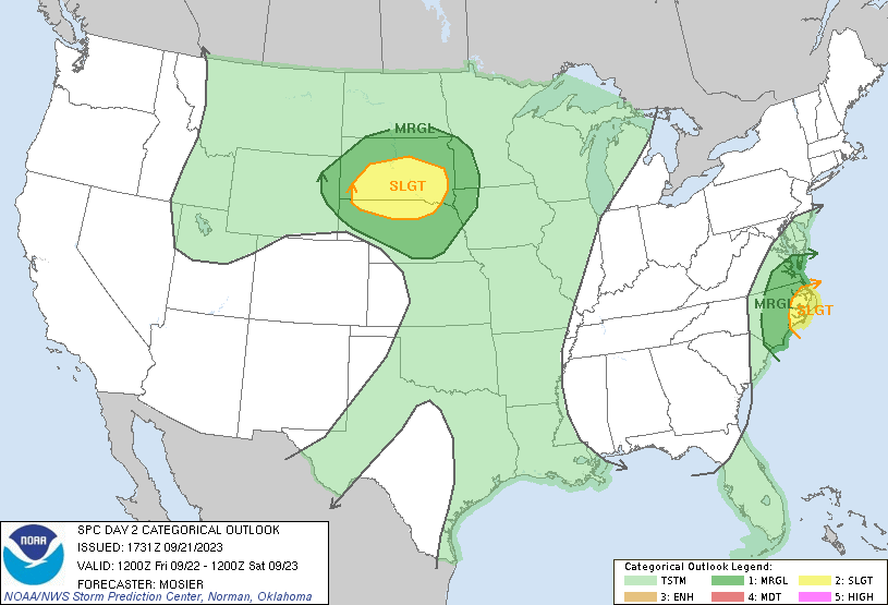
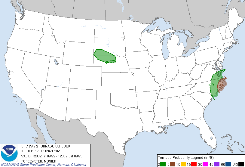
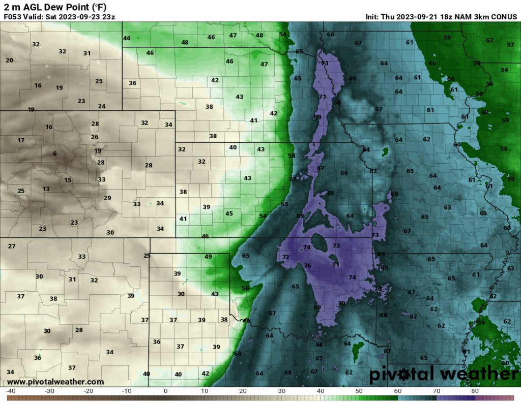
Looking to the weekend, we have a few potential severe weather events to keep an eye on. On Friday, a severe threat is forecast across much of the northern Plains, particularly in Nebraska and South Dakota. The biggest threat, according to the SPC, is hail, with the Slight Risk corresponding to an elevated hail threat (15% chance within 25 miles of a point). There is also a marginal wind threat and a marginal tornado threat as well, according to the SPC. Shear is sufficient for severe development, so the limiting factor in determining severe potential appears to be instability. Some areas are forecast to have around 1000 J/kg of CAPE, perhaps a little more, which is not a huge amount but is still sufficient for severe weather if shear is strong. Dew points are moderate, with values in the upper 50s to low 60s currently forecast. The severe threat should ultimately depend on how much CAPE and moisture is present, and any areas with elevated values of either will see the greatest risk for severe weather.
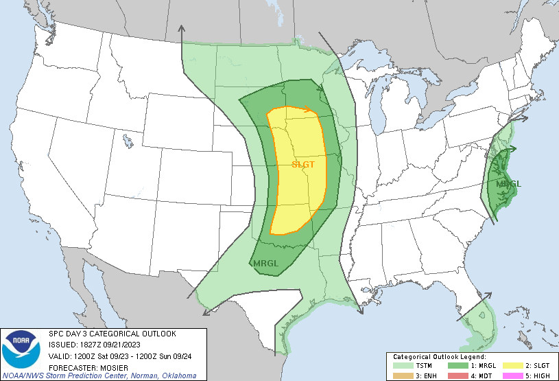
The threat I am more concerned about is Saturday’s severe threat. There is a chance the storms Friday evening across the northern Plains may continue and produce some severe threat on Saturday morning, but the bigger threat is Saturday afternoon and evening across much of the areas outlined in the Slight Risk. The NAMNEST model shows a line of storms extending from eastern Oklahoma and NW Arkansas to as far north as North Dakota and Minnesota. The greatest threat from these storms would likely be damaging straight line winds. What I am most concerned about, however, is eastern Oklahoma. The NAMNEST shows multiple supercells forming in this area in the evening. The model shows CAPE values above 3000 J/kg in some areas, shear values above 40 kts (approaching 50 kts in some areas), and dew points in the 70s. These are excellent values for severe weather, and if this model’s outlook holds, I would expect a tornado threat in the area. I would not be surprised if the SPC upgrades the risk to Enhanced in this area in a future update. Of course, this is one model’s outlook, and the risk should become clearer when the HRRR model updates later tonight, as the HRRR is another good model to look at for forecasting severe weather. Those in the risk areas should check their forecasts as they update tomorrow and Saturday.
I do want to note that although the predictability is too low at this time, the SPC currently is discussing the potential for severe weather on Sunday in the Southern Plains and around the ArkLaTex region (the general region around the border of Texas, Arkansas, and Louisiana). They currently do not have a specific risk area outlined due to uncertainty in the timing of an approaching trough and cold front, but I would not be surprised if the SPC issues a risk area in a future update. It is too soon to tell exactly where this risk area will be, however, owing to the predictability being low at this point. I figured I should make a note of it since the SPC discusses it on their Day 4 outlook.
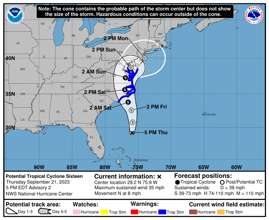
You may have noticed I skipped over a severe threat over some of the East Coast states. Well, that severe threat is due to a potential tropical storm forecast to make landfall this weekend. This storm currently is not a named storm, but the NHC projects the system to likely develop into a tropical storm as early as tonight. Parts of the North Carolina, Virginia, and Maryland coasts are currently under a tropical storm warning. Storm surge, strong winds, and flooding are all threats with this tropical system. Additionally, as the SPC notes, there is a tornado threat along the parts of the East Coast outlined in the Day 2 and Day 3 risk areas.
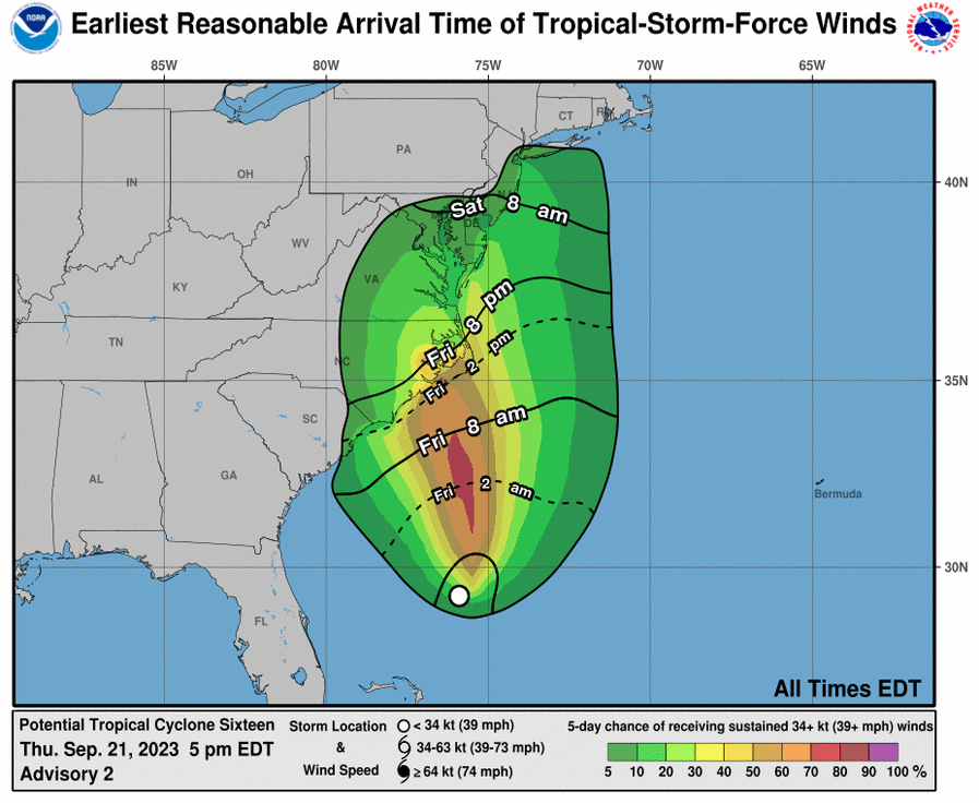
The above map shows the earliest reasonable time any given area may experience tropical-storm-force winds. Most likely, the winds will arrive a bit later than this, but it’s a good idea to make sure all preparation plans are finished by this time, just to be safe.
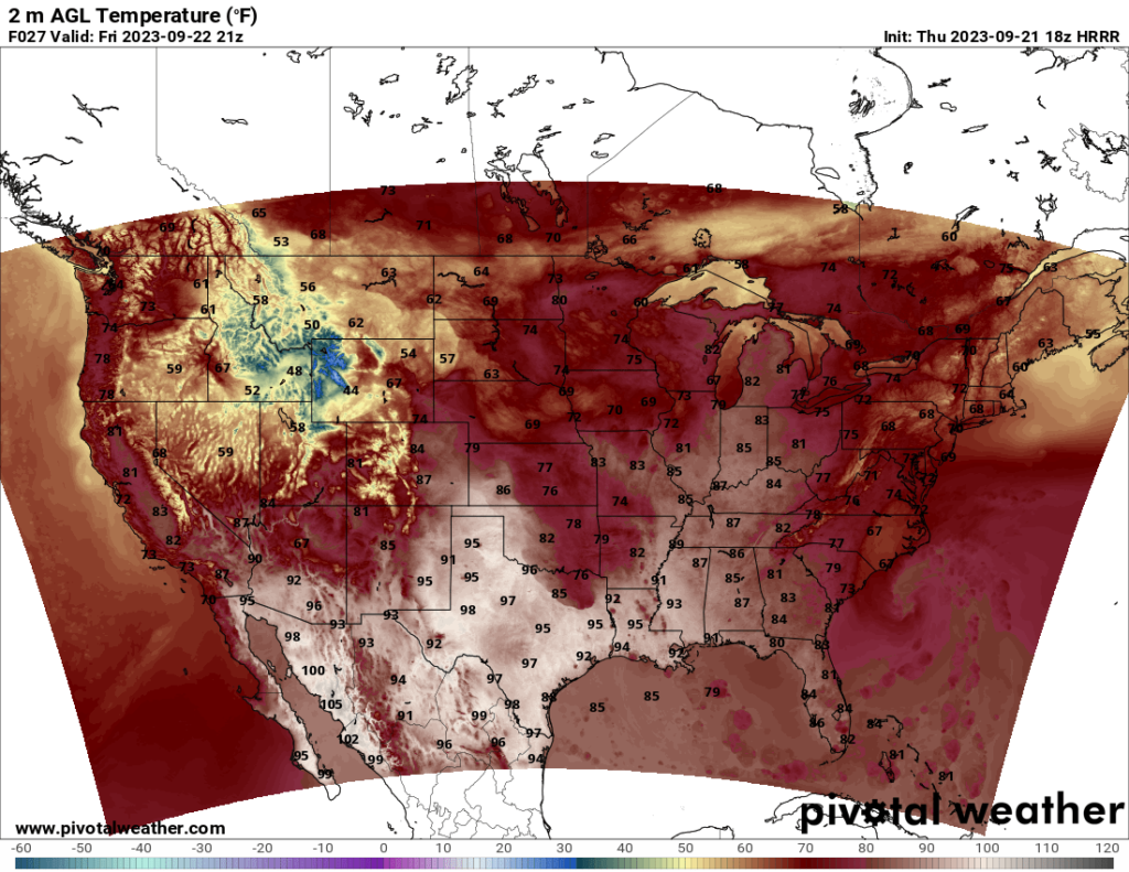
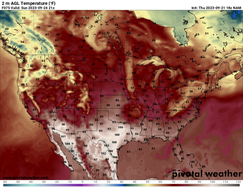
Looking at the temperatures, much of the US will see fall-like temperatures over the weekend, and parts of the mountainous regions in the West may see some chilly temperatures. The one area that can’t seem to let go of the summer heat is Texas, which I’m sure is frustrating the residents there. Most of the US should see pleasant temperatures this weekend, though.