Land does not bode well for tropical system organization. The lack of a fuel source (water), the topography (hills), and the inconsistent low-level airflow often limits the ability for tropical systems to stay organized.
Its like trying to spin a quarter on a smooth desk top, and then trying to spin a quarter on the beach. One is markedly easier than the other.
That leads us to this…

The National Hurricane Center is monitoring this area for the potential remnants of Agatha – the first named system of the year in the Pacific – to form into a tropical system.
The concern is that Agatha is going to drift north into Mexico and then drift into the Bay of Campeche.
The Data
However, given the model data today – and yesterday – that scenario seems a bit less likely. A more likely outcomes is that Agatha gets dragged across Mexico, Guatemala, Belize and Honduras first. Then gets deposited into the Caribbean.
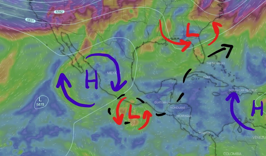
The reason? There is currently a ridge of higher pressure present over Mexico. Model guidance shows this ridge sagging to the west and falling apart. And the steering force that it would apply to Agatha also is pulled west. Leaving it free to move more northward.
However, looking at the data up around 300mb, where the tops of the clouds would be reaching, there is some strong west-to-east shear across the Gulf from the GFS model. And this shear is running against the natural spin of the tropical system.

So, that shear is likely to (A) tear apart the storm and (B) shove the system farther east.
It is operational guidance, but it is also only looking out 48 hours. Beyond that, we can look at the ensembles.

They have no real trend one way or the other after this thing moves ashore. And that gives me very little confidence that it will end up in the Bay of Campeche as any kind of organized tropical system. If the operational model of the GFS takes it to the east across Mexico and through – at least – Belize, the raw model data supports taking it to the east through – at least – Belize, and the ensembles show no discernable trend for it to not go to the east, that limits my trust that it won’t go east.
Could it get into the Bay of Campeche? Sure. Could it develop into a tropical system again int eh Bay of Campeche? Sure.
Is that a likely outcome? Probably not.
The Bottom Line
So you will probably see a lot of posts, updates, model maps, and scary looking stuff floating around. But at this point in time there is not enough evidence to warrant any kind of change in behavior from anyone. Nor is it time to do anything more than you should already be doing this time of year.
That includes, double checking your hurricane preparedness kit, making sure you have all of the supplies you need (canned food, water, etc), and looking over your insurance to make sure you’re covered. But that would also be my recommendation if there was nothing happening.


