New data is trickling in and we are starting to get a better idea about what to expect from Mother Nature on Monday afternoon, evening and into the overnight hours.

The great thing about getting within 48 hours of an expected event is it opens the doors to a lot of high-resolution data that just can’t “see” far enough into the future to give an accurate forecast more than about 48 hours out.
Forecast changes
— Model data is starting to suggest the cold front may move through – along with the showers and thunderstorms – a bit earlier. Model data is now showing storms showing up as early as 3pm for some, and lingering around as late as midnight for others.
— There is a higher likelihood for storms to form ahead of the line than earlier model data was showing. The storms ahead of the line are the storms that are more likely to produce the more significant severe weather. Right now, we still don’t know exactly there the most significant severe weather will be.
— Heavier rainfall is looking more likely, too. Rainfall totals of up to 3″ possible in some places. Right now, we still don’t know know where the heaviest rain will be.
Severe Weather Threats & Timeline
For the Pine Belt, the severe weather will be most likely between 3p and 9p.
3p – 9p: The main threats during this time frame is heavy rain, frequent lightning, wind gusts up to 70mph, hail up to the size of quarters and the potential for a tornado or two. If a tornado does occur, it would be as strong as an EF-3 (wind up to 165mph).
9p – 3a: Severe weather should be slowing down during this time and coming to an end completely by the end of this time frame. During this time, heavy rain, frequent lightning, wind gusts up to 60mph, hail up to the size of dimes and the potential for a tornado.
Updraft Helicity Streaks
I’ve mentioned these in the past, but if this is your first time hearing about them, I’ve used “Updraft Helicity Streaks” to identify where the strongest storms may be. In this case,, looking across all of the avialable data, there are a lot of places where the potential for severe weather exists.
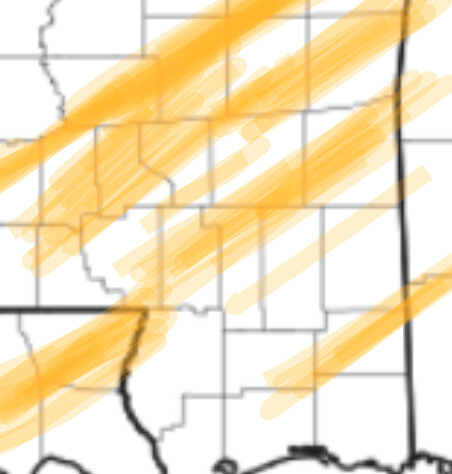
I want to stress that if you look at the above map and there isn’t a highlighted area near you, it doesn’t mean – by any means – that you are in the clear. There is a chance for severe weather across the entire area. The highlights are there to outline areas where more significant severe weather may be possible.
Discussion from the SPC
Day 2 Convective Outlook
NWS Storm Prediction Center Norman OK
1118 AM CST Sun Dec 15 2019
Valid 161200Z – 171200Z
…THERE IS AN ENHANCED RISK OF SEVERE THUNDERSTORMS FROM CENTRAL LOUISIANA TO WEST-CENTRAL ALABAMA…
…SUMMARY…
Scattered severe storms are expected Monday into Monday night from the Sabine River Valley through Louisiana, Mississippi, Alabama and the western Florida Panhandle. Locally damaging wind gusts, a couple of tornadoes, and isolated/marginal hail are all possible.
…Synopsis…
Flanked by both upstream and downstream ridging, a positively tilted upper trough is forecast to gradually advance across the central U.S. Monday. In response to this feature, weak surface cyclogenesis — initially near the Sabine River — is expected, with a weak low then shifting across the lower Mississippi Valley through the day. The low should accelerate northeastward overnight, reaching the West Virginia vicinity late in the period. Meanwhile, a trailing cold front is forecast to likewise cross the lower Mississippi Valley through the day, and then continue eastward across the central Gulf Coast states and Mid South region through the end of the period.
…Western and central Gulf Coast north to the Tennessee Valley…
Elevated showers and embedded thunderstorms will likely be ongoing at the start of the period across portions of the outlook area, and northward across the Mid South and into the central Appalachians, in a broad zone of low-level warm advection ahead of the advancing upper system. Though the boundary layer will continue to moisten, it should remain capped by warm air in the 850mb to 700mb layer early in the period. By mid to late morning however, very modest low-level warming/destabilization, and continued ascent — most pronounced near a slowly evolving cold front — will gradually permit isolated development of surface-based convection to occur. Convection should gradually increase in coverage/intensity through midday and into the afternoon, though limited by weak low-level lapse rates, and modest CAPE. Still, with amply supportive directional and speed shear within the warm sector, and coupled northern- and southern-stream upper jets yielding favorable storm-top divergence across the lower Mississippi Valley area into the afternoon, a few sustained/rotating storms are expected. These stronger storms should remain largely embedded in a broader, loosely organized frontal convective band, which should shift across eastern Louisiana and Mississippi through the afternoon, and eventually into parts of northern and central Alabama. Along with potential for locally damaging winds within the convective band, individually rotating updrafts will pose some risk for tornadoes.
By late evening, storms will likely begin to diminish, as an already marginal thermodynamic environment begins stabilizing. Some risk may linger, however, with a couple of more intense storms within the frontal band, into the overnight hours.
…MAXIMUM RISK BY HAZARD…
Tornado: 5% – Slight
Wind: 30% – Enhanced
Hail: 15% – Slight


