Welp, it wouldn’t be December with the potential for severe weather, would it?

From the SPC:
Forecast guidance continues to trend slightly southward with the evolution of the mid/upper trough ejecting across the Plains on Monday, as well as in the evolution of the surface low over the lower MS Valley region. Latest guidance is in good agreement that a weak low will develop over northern LA with an inverted trough extending northeast across MS into TN/KY. The low will track northeast along the trough/frontal wave the TN Valley vicinity around 00z and the central Appalachians by 12z Tuesday. A trailing cold front will push eastward across the lower MS Valley, located from eastern TN to near Mobile AL and the western Gulf of Mexico by the end of the period.
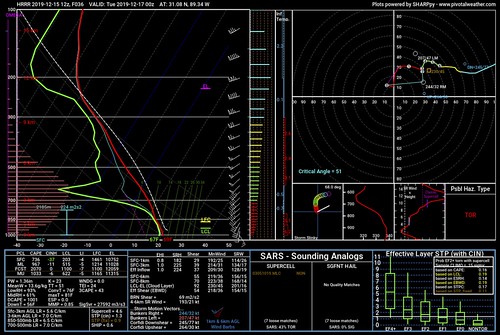
A strong southwesterly jet continues to be forecast, and 700 mb winds around 40-55 kt will be in place across much of the South Monday morning. An 850 mb low level jet around 35-50 kt also is forecast to persist across the Gulf Coast states for much of the period. Strong southerly low level flow will transport mid 60s F dewpoints as far north as central MS/AL with 70s F dewpoints closer to the coast. While cloud cover will limit stronger heating, this rich boundary-layer moisture beneath 6.5-7.0 C/km lapse rates will result in MLCAPE values from near 500-1500 J/kg. Furthermore, impressive vertical shear will support rotating updrafts/supercells.
Some uncertainty in storm mode remains, as deep-layer flow above around 1-2 km is generally parallel to the surface front, which would generally support more linear and/or cluster storm modes. However, some guidance shows considerable backing of low level winds ahead of the front, resulting in rather large low level hodographs and increased frontal convergence. If this scenario pans out, mixed modes including bowing line segments/clusters and semi-discrete supercells will be possible. Regardless of storm mode, damaging winds appear likely given relatively fast storm motion and strong flow in the presence of an adequate thermodynamic environment. Tornadoes will also be possible, via mesovortex processes in line segments, as well as with any discrete supercells that develop. Finally, midlevel lapse rates are stronger than typical across the region, which will aid in hail production with more isolated storm modes.
Various guidance has indicated a secondary and/or later threat may emerge over portions of southern AL toward the western FL Panhandle. A lead impulse as been evident in the last several forecast cycles and this could support convection well ahead of the cold front, or aid in further development/persistence of severe storms from Monday evening into the overnight hours. Uncertainty is higher in this scenario compared to the rest of the outlook area, but the Slight and Marginal risks have been shifted eastward to account for this possibility.
…MAXIMUM RISK BY HAZARD…
Tornado: 5% – Slight
Wind: 30% – Enhanced
Hail: 15% – Slight
The Setup
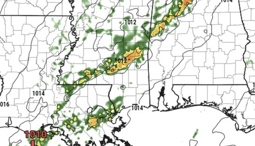
On Monday, a cold front will swing through the area with a chance for showers and storms. Right now, there is some disagreement between the models as to which ‘storm mode’ we will see, but the overall setup is one that will bring the area – at least – heavy rain, frequent lightning, gusty wind and small hail. At this point a tornado can’t be ruled out either.
The cold front is going to be “laying down” as it approaches, because of that the overall threat for severe weather will end up being limited to specific spots rather than some widespread outbreak. So, in other words, in places where the atmosphere comes together just right… there is a potential for some pretty potent weather, while down the road, there may be a heavy downpour and a few strong gusts of wind.
But at this point, the Storm Prediction Center has increased the risk for an Enhanced Risk – or a “3” on the 1 to 5 scale where “5” is the highest risk.
The Timeline for storms
4p – 7p: No storms in our area. At this point we will still likely be playing the Waiting Game. While there will be clouds and it may be a bit breezy, the threat for severe weather at this point is about zero.
7p – 10p: Storms begin to enter our western counties at this point. Places like Magee, Monticello, Bassfield, Columbia, Tylertown, Collins, and Taylorsville will start to see storms develop and move through. A lot like I mentioned above, some storms may be severe, while other are just regular Mississippi thunderstorms. At this point we can’t nail down specifics.
10p – 1a: Storms will cross the I-59 corridor and into our eastern counties. Places like Laurel, Hattiesburg, Purvis, Lumberton, Petal, New Augusta, and Waynesboro will have a chance for storms. A lot like I mentioned above, some storms may be severe, while other are just regular Mississippi thunderstorms. At this point we can’t nail down specifics.
1a – 4a: Storms will begin to affect places like Leakesville, McClain, Lucedale and other places in our far southeastern counties. A lot like I mentioned above, some storms may be severe, while other are just regular Mississippi thunderstorms. At this point we can’t nail down specifics.
4a – 7a: Storms exit the area.
What we are trying to nail down
If you read these severe weather discussions regularly or watch my facebook videos, you guys are probably aware of my growing love of the things I call “Updraft Helicity Streaks.”
If you’re new to the area, or new to these discussions, The “UHS” are model data that try to isolate – given a ton of atmospheric parameters – the most likely place where there will be a rotating updraft within any thunderstorms. That is important because a rotating updraft is the key ingredient you need for producing organized severe weather.

In this case, the UHS data shows a few spots across our area where the tornado potential may be a bit higher if – BIG IF! – storm mode can stay discrete / supercellular. So the severe weather risk, at this point to me, is a conditional threat. If – again, BIG IF! – storms are discrete / supercellular the potential for an EF-2 or stronger tornado increases.
If storms are all just in a line? One or two EF-0 and EF-1 tornadoes can’t be ruled out completely.
But, at this point, we just don’t know enough to stick our flag in the ground and make a proclamation.
What to hope for
A lot of times people ask, “What can we hope for to happen, so that there is no severe weather?” and in this case, I don’t think we will get out of this with zero severe storms. However, if you want to hope for something, hope that “the atmospheric wind is parrallel to the front” so that organization can’t develop in the storms. That will also mean storms will likely all form in a line, with no storms out ahead of the line. Because if all these storms cluster together and form a straight line, the threat for tornadoes will go down quite a bit.
Bottom Line
There is a threat for severe weather between about 7p on Monday night through about 4a on Tuesday morning. There is the potential for heavy rain, gusty wind, frequent lightning, hail (up to the size of quarters) and the potential for a tornado.


