I’m posting this update pretty late. It is almost 1:00 AM as I write this, so enjoy this scientific stream-of-barely-consciousness…
The National Hurricane Center has increased the chances of development in the Gulf to 10-percent during the next 48 hours. And is at 20-percent during the next five days.
Not crazy high numbers, by any means, but not zero either.

The “July Cold Front” in the South is the culprit behind this chance for development. So let’s take a peek at what that may mean…
Time for Science!
Starting with the continental view of the 500mb map on Thursday at 7am. You can see a handful of features in the mid/upper levels of the atmosphere. Two big ridges of high pressure (blue Hs) and five areas of low pressure (red Ls).
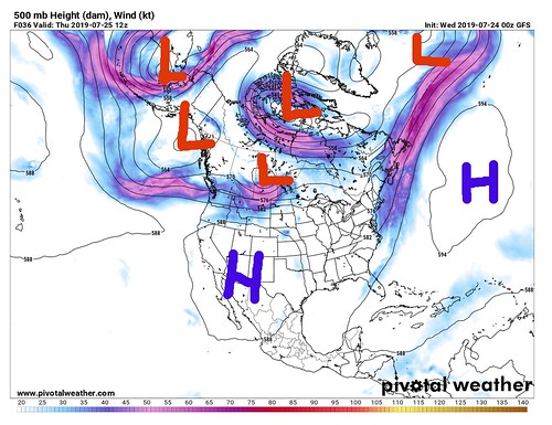
The interesting thing to note here is that the areas of low pressure are at lines of latitude north of the United States. The area os high pressure are farther south. In general, this is because during the summer, two large ridges of high pressure usually dominate the weather pattern for the United States – the Bermuda High and a Pacific High
That locks all of the “weather” up north across the northern tier of the lower 48 and into Canada.
But that changed when a weakness developed between the two ridges of high pressure.

The circled area is the weakness between the ridges. That weakness up at 500mb is one of the reasons the “July Cold Front” made it as far south as it did.
Once that happened, it threw a wrench in a lot of stuff.
What happens next?
Well, a July Cold Front is a reasonably rare event. I don’t recall one making it to the Gulf in July during the last five years. And I would have to consult the record books to attempt to find one during the last 15.
So, with complete transparency here, I’m not sure what happens next.
Computer models disagree. And since this is a reasonably rare event, that isn’t surprising. The National Hurricane Center has pegged the area of interest with a 20-percent chance of development, and I don’t think an argument can be made against that.
The GFS computer weather model is just starting to pick up on the development of an area of low pressure again.

And yeah, I said “again” right there! Originally, the GFS picked up on this feature about a week ago. Bu then it disappeared. And now it is back.
Again, I would argue that this is not surprising given the rarity of a July Cold Front. The computers are going to struggle with how to made heads or tails of it, so to speak.
Is this going to hit (insert place here)?
No idea. I wish I did, but I don’t. And anyone trying to tell you where this thing – what ever it may become, if anything at all – is going to go and hat it is going to do… they’re making it up. There is no ‘good’ science out there that can predict much of anything about this area of interest, yet.
Things you can do now
Just watch the Gulf and keep it tuned to the forecast. If anything changes – and it will – the NHC will let all of us know!


