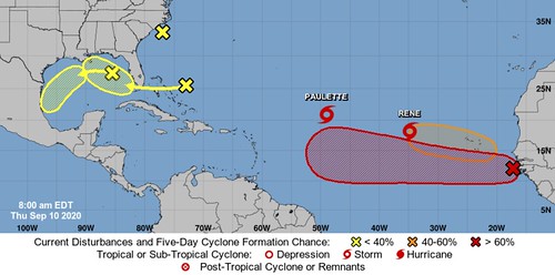
Welcome to the peak of Hurricane Season in the Atlantic. September 10th. Mother Nature must’ve gotten the memo. Right now, the National Hurricane Center is monitoring seven different areas for possible development.
From the NHC
The National Hurricane Center is busy. Here is a look at their tropical discussion…
The National Hurricane Center is issuing advisories on Tropical Storm Paulette, located over the central tropical Atlantic, and on
Tropical Storm Rene, located over the eastern tropical Atlantic.1. A trough of low pressure located just off the coast of North Carolina is producing minimal shower and thunderstorm activity. This system is expected to move inland over eastern North Carolina this afternoon, and therefore significant development is not expected.
* Formation chance through 48 hours…low…near 0 percent.
* Formation chance through 5 days…low…near 0 percent.2. A large area of disorganized showers and thunderstorms centered a couple of hundred miles northeast of the Central Bahamas is associated with a surface trough of low pressure. This system is forecast to move westward, crossing the Bahamas and Florida on Friday and moving into the eastern Gulf of Mexico over the weekend. Upper-level winds are expected to become conducive for some development of this system while it moves slowly west-northwestward over the eastern Gulf of Mexico early next week.
* Formation chance through 48 hours…low…near 0 percent.
* Formation chance through 5 days…low…30 percent.3. Another trough of low pressure has developed over the northeastern Gulf of Mexico and is producing a few disorganized showers and thunderstorms. Some slow development of this system is possible while this system moves westward and then southwestward over the northern and western Gulf of Mexico through early next week.
* Formation chance through 48 hours…low…10 percent.
* Formation chance through 5 days…low…20 percent.4. A tropical wave is now moving off the west coast of Africa, producing a large area of showers and thunderstorms. Gradual development of this system is forecast, and a tropical depression is expected to form by this weekend or early next week while the system moves generally westward across the eastern and central tropical Atlantic.
* Formation chance through 48 hours…medium…60 percent.
* Formation chance through 5 days…high…90 percent.5. Another tropical wave is forecast to emerge off the west coast of Africa this weekend. Environmental conditions are expected to be conducive for development, and a tropical depression could form over the far eastern tropical Atlantic Ocean early next week while the system moves slowly westward.
* Formation chance through 48 hours…low…near 0 percent.
* Formation chance through 5 days…medium…40 percent.
On satellite
Some good news, outside of Tropical Storm Paulette and Tropical Storm Rene, some of those areas aren’t very well organized at all. Particularly the areas closest to the mainland of the United States.

Both of the Tropical Storms, Paulette and Rene, are currently forecast to stay away from the United States. Paulette may scrape by Bermuda as a Tropical Storm – and perhaps even a Hurricane – early next week, but for now is pegged to miss the United States.
The Bottom Line
Since I know people are likely most concerned about the weekend at this point, there is a chance for some of these areas to impact parts of the United States this weekend. Nothing catastrophic is currently forecast, but heavy tropical rain and the potential for localized flooding is a concern.
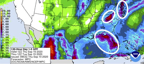
The Wether Prediction Center is showing the chance for 2″ to 5″ of rain across parts of the southeast through Monday night next week.


